


May Through August 2016
The following Fire Weather / Fire Danger Outlooks are made with the most recent weather data available. It is a general report intended to provide fire management personnel with an area wide outlook.
Highlights:
Above normal days of “monsoonal” summertime thunderstorms.
Above normal temperatures.
Fewer than average offshore wind events expected this spring.
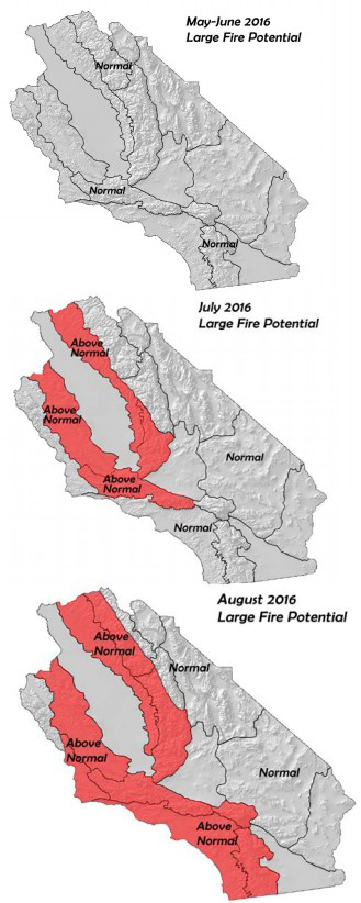
Above normal large fire potential over a large part of the area.
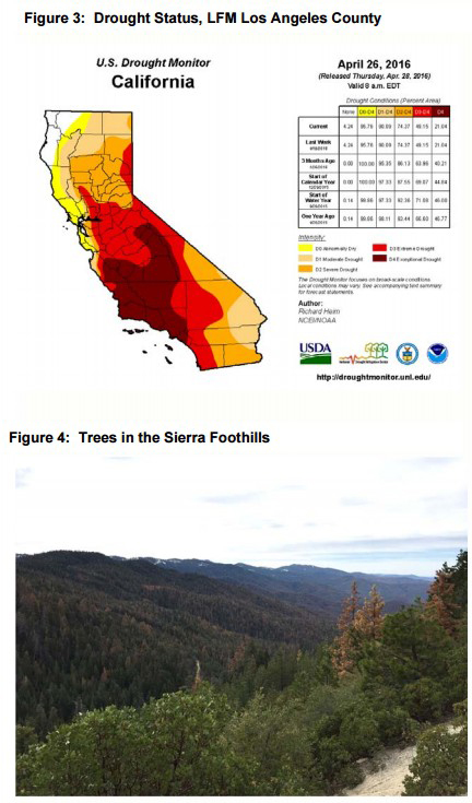
The highest large fire potential may be over the Sierra Foothills due to a high number of dead trees.
WEATHER DISCUSSION
May 3, 2016 - Springtime weather in California is often more tranquil than the rest of the country which is usually battered by severe weather in May and June. The change of the season usually brings a quick end to the rains of
 winter and coastal areas see a maximum of marine layer cloudiness and fog. Inland areas may see breezy conditions each afternoon due to strong pressure gradients.
 This year, both of these areas may see a less pronounced occurrence of typical springtime weather due to above normal sea surface temperatures. The marine layer inversions typical for this time of year may be weaker and perhaps more shallow which may keep daily night and morning stratus confined to the coastal areas with less inland penetration. Likewise, afternoon breezes may be weaker in the passes and desert interface regions as the temperature contrast between the desert and ocean may not be a strong as usual. A consequence of a less pronounced marine layer would be a higher number of warmer, drier days across inland areas with stronger sunshine during the morning hours.
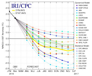
All long range model guidance indicates sea surface temperatures (SST) will quickly drop this summer into the fall. There is a growing consensus that a La Niña may develop this fall (Figure 2, below). However, there remains a large pool of above normal SST covering much of the eastern Pacific, including waters off the Mexican Coast. This area is often the spawning ground for tropical storms which affect the Southwest. Last year, was an extremely active year with 18 named storms with very warm SST likely playing a major role in developing these storms. While SST may not be a warm as last year, there still may be a higher than average amount of precipitable water in the atmosphere over the Southwest.
Figure 1: Possible Monsoon Pattern this Summer
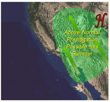
The strong ridge over the pacific has reappeared from time to time this spring which was a factor in the unexpectedly dry winter over Southern California. This ridge, if it continues to reappear during the summer, has brought periodic episodes of south and southeasterly flow across the area which has been efficient in transporting moist air from the tropics during each of the past 3 summers (Figure 1, above). The result has been above normal thunderstorm activity with an emphasis on wet storms at the expense of dry lightning storms. This may occur again this summer and above normal rainfall looks possible over the Sierras, San Diego County, San Bernardino and Inyo National Forests as well as the deserts.
It is important to note that a higher than normal number of summertime thunderstorms does not necessarily equate to a higher number of lightning generated storms. The last three summers have had far above normal levels of lightning across most of the district. But these storms were frequently accompanied by heavy rain.
Figure 2: Mid-April Plume of model ENSO Predictions
The fires started by such storms often appear days later in the form of “sleeper fires” once the monsoonal moisture departs the region. Dry lightning is by far the leading cause of starts in the Sierras and other thinly populated areas. The number of dry lightning events has been quite low the past few years which has played a role in keeping the number of large fires remarkably low given the historically dry conditions covering a large part of the state. This pattern is expected to continue this summer – a higher than normal number of storms, but most of the storms should produce some rainfall.
This summer, there is high confidence in above normal temperatures occurring once again, mainly due to warm SST.Frequent ridging and less marine layer coverage will also likely play a role in allowing for what looks like yet another very warm summer across the state.
FUELS AND DROUGHT OUTLOOK:
 At the current time, seasonal grasses have cured over Southern California for the most part and only shaded areas above 5,000 feet remain green. Live fine fuels across Central California are currently curing rapidly south of Fresno Counties. Higher elevations over 4,000 feet have quite a bit of moisture in the fine fuels as there have been several storms in April which have brought wetting rains to the area.
The hydrological conditions across the state are far more positive than at this time last year. Reservoir storage is near to above normal across many areas of Northern California, but lake levels are still very low across Southern California reservoirs. The warm weather has caused snowpack numbers to fall steeply in April. But the highest elevations still retain substantial snowpack and it will be several weeks before the alpine areas melt out. Therefore, large fire potential may remain near normal in the higher elevations of the Sierras until August.
There was a sharp dividing line between areas of Central and Northern California which had heavy rain over the winter and those areas further south that were dry. Most of South Ops area remained at or below normal in terms of winter rains, but one notable exception is the coastal areas of Monterey County and the far northern portions of the Stanislaus National Forest. These areas may see large fire potential remain near normal for much of the summer. The rest of the area will be left with another extended period of above normal large fire potential in coming months. The threat of large fires will be especially acute across the Sierra Foothills where there is a high incidence of tree mortality. Since many of these trees are evergreens which haven’t dropped their needles, they will readily accept flame and will show extremely rapid rates of spread during favorable fire conditions.
The summer monsoon may alleviate the drought somewhat in the deserts, but the rest of the area should continue to see the drought slowly expand. No substantial relief of the drought is expected during the next 3-4 months.
Source: NIFC

