
Click Here for: California Caldor Fire Tuesday, August 31, 2021 Updates
Evacuation Warnings - Effective Immediately for Douglas County, Nevada (7:30 P.M.)
Douglas County is asking the following communities to be on the alert and start preparing for potential evacuations. Evacuations have not been ordered for the following areas at this time; however, there is potential for evacuation warnings to heighten to evacuation orders in the near future. The communities possibly affected are:
Douglas County, NV - Evacuation Warning
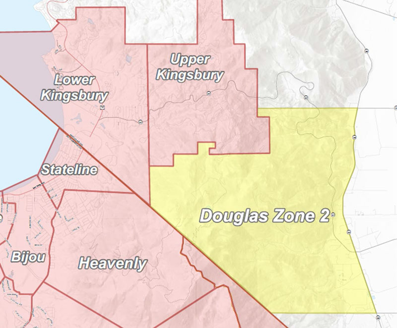
The following zone is affected: Zone 2 Any homes or property located on Foothill Road from Centerville Lane north to Muller. Included in this zone is the valley side of Kingsbury Grade and any homes that are accessed by Foothill Road between Centerville Lane and Muller Lane.
These communities are asked to be on the alert and start preparing for potential evacuations. Evacuations have not been ordered at this time, however there is potential for evacuation orders in the near future and road closures are imminent. Please stay vigilant, pay attention to emergency phone alerts, and have a plan in place.
Safety Message: Have a transportation plan for animals and livestock. Think about fuel, medications, keepsakes, documents, and groceries you might need. Think about your loved ones on oxygen or anyone who may need assistance leaving their home. Living with Fire has a Wildfire Evacuation Checklist for reference. To view, visit the following link: https://www.livingwithfire.com/wp-content/uploads/2018/10/Evacuation-Checklist-2020-one-page.pdf
Should evacuations occur, you wi11 receive an emergency alert notification on your phone and may be asked to leave your home by emergency responders. It is not recommended to wait for someone to visit your home. If you feel unsafe, leave the area. If you do not have a cell phone or landline, please keep in contact with friends, neighbors, co-workers, and family.
Evacuation Shelters:
- Douglas County Community and Senior Center - Douglas County Residents Only 1329 Waterloo Lane, Gardnerville, NV
- Reno Sparks Convention Center
4590 South Virginia Street, Reno, NV - Lyon County Fair Grounds – Dry Camp Only
100 95A East, Yerington, NV - Dayton Event Center/Rodeo Grounds — Dry Camping Only
500 Schaad Lane, Dayton, NV
Animal Shelters:
• Reno Sparks Convention Center
4590 South Virginia Street, Reno, NV
*Limited crates and space available for pets
- Lyon County Fair Grounds – Dry Camp Only
100 95A East, Yerington, NV - Dayton Event Center/Rodeo Grounds — Dry Camping Only
500 Schaad Lane, Dayton, NV - Douglas County Caldor Fire
920 Pinenut Road, Gardnerville, NV
Update to Evacuation Orders, Warnings, and Road Closures - Effective Immediately for Alpine County (4:45 P.M.)
Evacuation Orders Alpine County:
Highway 88 at Forestdale Road. West of Forestdale Road and south to the Pacific Crest Trail Crossing. West of the Pacific Crest Trail to the Summit City Canyon Trail. West of Summit City Canyon Trail and south to the El Dorado / Stanislaus National Forest Line. El Dorado / Stanislaus National Forest Line west to the Alpine and Amador County line.
North of Highway 88, along the Alpine/EI Dorado County line and Armstrong Summit to the Nevada state line. West of the Nevada state south to Luther Creek. Northwest of Luther Creek to Woodfords. North of Highway 88 and Highway 89 to the Alpine/EI Dorado County line.
Evacuation Warnings Alpine County:
- North of Highway 89 from Woodfords due north to Luther Creek at the Nevada State line.
- East of Forestdale Road and south to the Pacific Crest Trail Crossing.
- East of the Pacific Crest Trail to the Summit City Canyon Trail.
- East of Summit City Canyon Trail and south to the El Dorado / Stanislaus National Forest Line.
- El Dorado / Stanislaus National Forest Line east to the northern lake edge of Upper Blue Lakes.
- North of the North-west Lake edge of Upper Blue Lake to the southern aspect of Hawkins Peak and to Woodfords junction.
- South of Highway 88 at Woodfords Junction to Forestdale Road
NOTES: All previous evacuation orders and warnings remain in effect A mandatory evacuation order is defined as an immediate threat to life. This is a lawful order to leave now. The area is lawfully closed to public access. An evacuation warning is defined as a potential threat to life and/or property. Those who require additional time to evacuate, and those with pets and livestock should leave now.
Evacuation Orders - Effective Immediately for Douglas County, Nevada (4:00 P.M.)
The following Evacuation Orders are being issued for the areas below.
The following affected communities in Douglas County, Nevada (excluding Stateline Casinos) are:
- Upper Kingsbury (South)
- Upper Kingsbury (North)
- Central Kingsbury
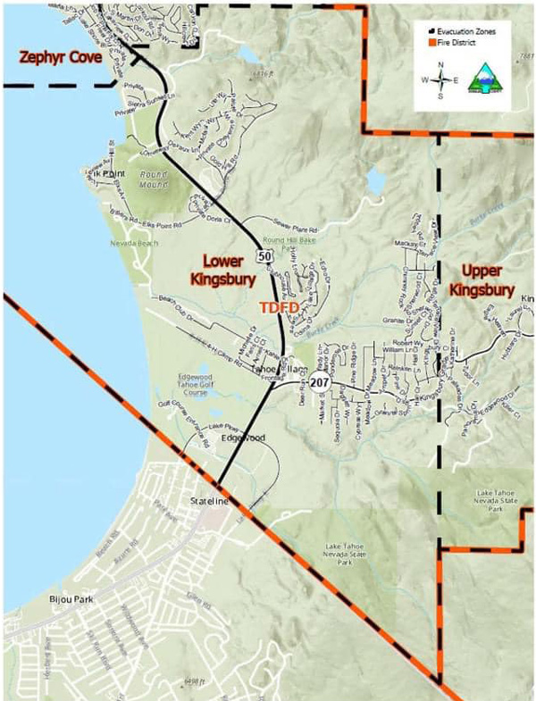
- Lower Kingsbury
- Round Hill region and roads including Lower Elks Point
- Lake Village
- Lower Olivers, Kahle Drive region and roads
These Evacuation Orders will include areas from Highway 50 at Lake Parkway, East to Elks Point Road (excluding Stateline Casinos) and State Route 207 (Kingsbury Grade) from Highway 50 to Tramway Drive, including all area roads North and South of Kingsbury Grade.
Nevada Department of Transportation — Road Closures:
The following are soft road closures. meaning the roads are open to residents and employees who must enter the area to access their home or work.
- US 50 going west bound (into the Tahoe Basin) at Spooner Jct. (S. Carson St 8, 50)
- SR 207 west bound at Foothill Rd (intersection at the bottom of Kingsbury Grade)
- SR 28 and US 50 Jct. West Bound on 50
These communities are asked to be on the alert and start preparing for potential evacuations. Evacuations have not been ordered at this time, however there is potential for evacuation orders in the near future and road closures are imminent. Please stay vigilant, pay attention to emergency phone alerts, and have a plan in place.
Safety Message: Have a transportation plan for animals and livestock. Think about fuel, medications, keepsakes, documents and groceries you might need. Think about your loved ones on oxygen or anyone who may need assistance leaving their home. Living with Fire has a Wildfire Evacuation Checklist for reference. To view, visit the following link: https://www.livingwithfire.com/wp-content/uploads/2018/10/Evacuation-Checklist-2020-one-page.pdf
Should evacuations occur, you wi11 receive an emergency alert notification on your phone and may be asked to leave your home by emergency responders. It is not recommended to wait for someone to visit your home. If you feel unsafe, leave the area. If you do not have a cell phone or landline, please keep in contact with friends, neighbors, co-workers, and family.
Evacuation Shelters:
- Douglas County Community and Senior Center - Douglas County Residents Only 1329 Waterloo Lane, Gardnerville, NV
- Reno Sparks Convention Center
4590 South Virginia Street, Reno, NV - Lyon County Fair Grounds – Dry Camp Only
100 95A East, Yerington, NV - Dayton Event Center/Rodeo Grounds — Dry Camping Only
500 Schaad Lane, Dayton, NV
Animal Shelters:
• Reno Sparks Convention Center
4590 South Virginia Street, Reno, NV
*Limited crates and space available for pets
- Lyon County Fair Grounds – Dry Camp Only
100 95A East, Yerington, NV - Dayton Event Center/Rodeo Grounds — Dry Camping Only
500 Schaad Lane, Dayton, NV - Douglas County Caldor Fire
920 Pinenut Road, Gardnerville, NV
For additional information, scan the QR code above or visit https://linktr.ee/imt6
Source: California Department of Forestry and Fire Protection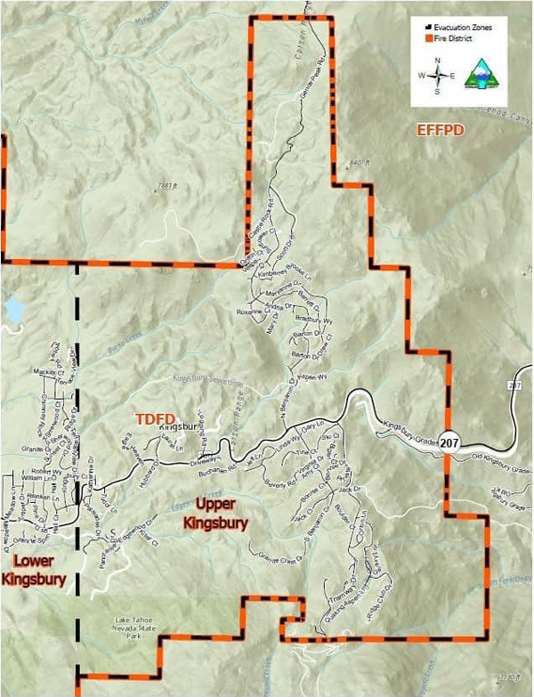
Update to Evacuation Orders, Warnings, and Road Closures - Effective Immediately for Alpine County
Evacuation Orders Alpine County:
August 31, 2021 - Highway 88 at Forestdale Road. West of Forestdale Road and south to the Pacific Crest Trail Crossing. West of the Pacific Crest Trail to the  Summit City Canyon Trail. West of Summit City Canyon Trail and south to the El Dorado / Stanislaus National Forest Line. El Dorado / Stanislaus National Forest Line west to the Alpine and Amador County line.
North of Highway 88, along the Alpine/El Dorado County line and Armstrong Summit to the Nevada state line. West of the Nevada state south to Luther Creek. Northwest of Luther Creek to Woodfords. North of Highway 88 and Highway 89 to the Alpine/El Dorado County line.
Evacuation Warnings Alpine County:
- North of Highway 89 from Woodfords due north to Luther Creek at the Nevada State line.
- East of Forestdale Road and south to the Pacific Crest Trail Crossing.
- East of the Pacific Crest Trail to the Summit City Canyon Trail.
- East of Summit City Canyon Trail and south to the El Dorado / Stanislaus National Forest Line.
- El Dorado / Stanislaus National Forest Line east to the northern lake edge of Upper Blue Lakes.
- North of the North-west Lake edge of Upper Blue Lake to the southern aspect of Hawkins Peak and to Woodfords junction.
- South of Highway 88 at Woodfords Junction to Forestdale Road
NOTES: All previous evacuation orders and warnings remain in effect A mandatory evacuation order is defined as an immediate threat to life. This is a lawful order to leave now. The area is lawfully closed to public access.
An evacuation warning is defined as a potential threat to life and/or property. Those who require additional time to evacuate, and those with pets and livestock should leave now.
Safety Message: The public is reminded to stay vigilant on current fire conditions. Please continue to adhere to road closures and any evacuation orders and warnings. A reminder to drive slowly and yield to emergency personnel in the area. There will be smoke in the respective areas as firefighters continue firefighting operations. If at any time you feel unsafe, please call 911.