
California and National Drought Summary for January 23, 2018
Summary
January 25, 2018 - A westerly flow dominated the upper-level circulation across the contiguous U.S. (CONUS) during this U.S. Drought Monitor (USDM) week. The week began with a frontal system exiting the eastern CONUS, and ended with another Pacific system moving across the country. The systems brought an inch to more than locally 5 inches of precipitation to the coasts and Cascades of northern California to Washington; 1 to 2 inches of precipitation to parts of the northern Rockies and in swaths from eastern Nebraska to the Great Lakes and from southeastern Oklahoma to the Mid-Mississippi Valley; and a few reports of 1 inch or more across parts of the South and Southeast. These amounts translated to above normal for the central Plains to western Great Lakes, parts of the Pacific Northwest, the swath from southeastern Oklahoma to the Mid-Mississippi Valley, and a few areas in the South and Southeast. But for large parts of the country, the week was drier than normal, with little to no precipitation falling across large parts of the Southwest and Southern Plains. The westerly flow brought above-normal temperatures to most of the West and across the northern states, especially the Northern Plains to western Great Lakes where weekly temperature departures were 9 to 15 degrees above normal. Weekly temperatures averaged below normal across the southern states from eastern Arizona to North Carolina, where the effects of earlier cold air masses still lingered. Contraction of drought and abnormal dryness occurred with the large winter storm that dumped on eastern Nebraska to the Great Lakes, and contraction occurred in a few other areas in the southern Plains and Northeast. But the continued dry conditions in the Southwest to Southern Plains and Southeast intensified and expanded drought and abnormal dryness in these areas.Northeast
Precipitation amounts were mostly under an inch for the week and generally below normal. With monthly precipitation near normal and streamflows above normal, D0 was pulled out of Hartford County in Connecticut. But otherwise the precipitation was enough to prevent expansion of drought and abnormal dryness but not enough for additional improvement.Southeast
The fronts blasted through the Southeast at the beginning and end of the week, but precipitation amounts were generally below normal with only a few stations reporting an inch or more. Low streamflows, drying soils, and drought indices (such as the Standardized Precipitation Index, or SPI) tanking for the last 1 to 3 months prompted the expansion and intensification of drought across much of the region. This is the recharge season for the Southeast, but there is little evidence that moisture recharge is occurring. D2 was added to northern Virginia; D0-D2 expanded across parts of Florida, Georgia, and Alabama; D1 spread into the southwest corner of North Carolina; and D0 expanded eastward in South Carolina.South
D0-D1 were pulled back slightly in southeastern Texas where over an inch of rain fell this week, but otherwise the South saw large areas of degradation. D0-D3 expanded in Oklahoma and Texas, D1 nudged slightly further across extreme northwestern Arkansas, and D0-D1 expanded in Tennessee. Locally 1-3 inches of rain fell across parts of southeastern Oklahoma to northern Arkansas, but the dryness was so severe here that the rain only staved off further deterioration. The County Executive Director for Wagoner and Mayes Counties in Oklahoma reported that all of the winter wheat crop was in either poor or very poor condition, and some producers were selling cattle early due to poor grazing fields; the Oklahoma State Climatologist reported several counties have issued burn bans in response to a rash of fires which resulted, in part, from the prolonged drought. As relayed by the National Drought Mitigation Center (NDMC), agricultural impacts from the drought are being felt in Utah, Kansas, and Oklahoma and include decreasing hay and soybean yields, deteriorating wheat and grazing conditions, and decreasing water supplies -- ponds and wells going dry. Some of these effects started from moisture deficits dating back to summer 2017. Some stations in the Texas panhandle and western Oklahoma haven’t had any precipitation for the last 3 months, including Amarillo, Texas where the last day with measurable precipitation was October 13, 2017, and Woodward, Oklahoma, which has gone over 100 days without measurable precipitation.Midwest
Parts of Iowa, Missouri, Illinois, Wisconsin, and Michigan received over an inch of precipitation this week, while other states in the Midwest were much drier. Stations across most of Minnesota and parts of northern Wisconsin and Michigan reported no precipitation, while stations from Kansas City to the Quad Cities were in a dry slot associated with the late week winter storm. D0 and D1 contracted in northwestern to south central Iowa, but D1 expanded from the Quad Cities region into northern Missouri and D0 poked into western Minnesota. The Iowa State Climatologist has received reports of low farm pond and well levels in southeast Iowa. As noted by the Missouri State Climatologist, drought impacts developed late last fall and are continuing this winter. These include: Producers are feeding hay due to minimal fall grass growth and little to no hay cuttings; some producers are moving cattle or hauling water because of low or empty ponds, or little to no flow in creeks and springs, and many are saying it’s worse than 2012; since many farmers are feeding hay earlier than usual, they are beginning to cull their herds to reduce the amount of animals that will need feed through the winter; producers will likely feed lower quality hay and cows will be in poorer condition coming out of the winter, which may reduce future calf crop numbers; and wells are running low or going dry. The Illinois State Climatologist has received reports from Livingston County of field drain tiles not flowing for some time, which is an indication of overall dry condition of the soil profile down to the depth of the tiles. As reported by the media, the dry conditions and lack of snow are impacting the local economy in Wisconsin, specifically inhibiting the snowmobile recreational industry.High Plains
An inch or more of precipitation was reported at stations in eastern Nebraska and a few stations in western Wyoming and the Colorado Rockies. Amounts dropped off to the north and south, with many stations in the Dakotas and Kansas measuring no precipitation for the week. D0 contracted in eastern Nebraska and southeastern South Dakota, and D2 was trimmed in western South Dakota, but D0 expanded in northeastern South Dakota and eastern North Dakota, D1 from Oklahoma crept into southeastern Kansas, and D2 from New Mexico pushed into southern Colorado. As relayed by the NDMC, agricultural impacts from the drought are being felt in Utah, Kansas, and Oklahoma and include decreasing hay and soybean yields, deteriorating wheat and grazing conditions, and decreasing water supplies -- ponds and wells going dry. Some of these effects started from moisture deficits dating back to summer 2017.West
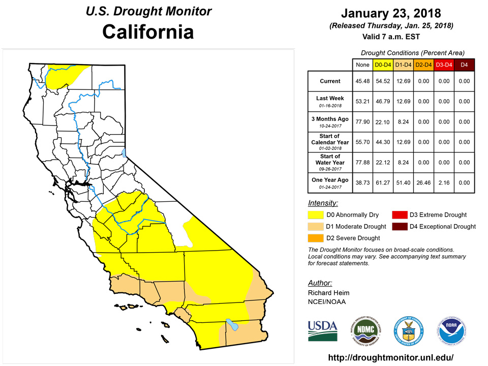
A Pacific low and frontal system brought rain and snow to parts of northern California, Washington, Oregon, and the northern Rockies. Amounts were heaviest in favored upslope areas, with some stations along the coast and in the Cascades reporting over 5 inches of precipitation. Six inches to over a foot of new snow was added to several high elevation SNOTEL stations. But this is the wet season when normals are high, so even with the beneficial precipitation, much of the West was drier than normal this week. The Pacific system dried out as it crossed the coastal ranges, and the precipitation largely missed the southern states in the West. Several stations in New Mexico have gone over a hundred days with no measurable precipitation, including Moriarty and Conchas Dam. The Weather Service office at Albuquerque has measured only 0.03 inch since October 5, 2017. Several SNOTEL stations in the Sangre De Cristos were reporting the lowest year on record for snow water equivalent (SWE). The low snowpack in the mountains was impacting the recreation industry (ski resorts), but some parts of New Mexico were beginning to see agricultural impacts, mostly forage. As relayed by the NDMC, agricultural impacts from the drought are being felt in Utah, Kansas, and Oklahoma and include decreasing hay and soybean yields, deteriorating wheat and grazing conditions, and decreasing water supplies -- ponds and wells going dry. Some of these effects started from moisture deficits dating back to summer 2017. D1 expanded in southeastern New Mexico; D2 grew in southwestern and northern New Mexico and into adjacent southern Colorado, and expanded in central and southern Arizona; and D0 expanded into the Sierra Nevada Mountains of central California. The California D0 expansion reflected low mountain snowpack values; many lakes and reservoir levels were down as part of flood mitigation activities, but water supply was adequate. The low SWE and precipitation values, as well as high evaporative demand due to above-normal temperatures, were widespread across California and Nevada, but no additional changes were made this week due to the Pacific storm and normal to above-normal streamflows.Alaska, Hawaii, and Puerto Rico
In Hawaii, D1 was removed from the southern portions of the Big Island, a sliver of D1 was added to the western coast where drought impacts were evident, and D0 was contracted in the east. Other than on the Big Island, no changes were made to the USDM depiction in the Hawaiian Islands, Alaska, and Puerto Rico.Looking Ahead
In the 2 days since the Tuesday morning cutoff time of this week’s USDM, one storm system moved across the Northeast and exited the CONUS while another Pacific low and frontal system was moving into the Northwest. The Pacific system will dry out as it crosses the Rockies, then pick up Gulf of Mexico moisture when it moves across the eastern half of the country. For January 23-30, 5+ inches of precipitation is forecast for the coastal regions from northern California to Washington and up to 5 inches for northern Idaho, with lesser amounts from central California to Montana. When the system crosses the Plains, another region of precipitation will develop with amounts ranging from half an inch to locally over an inch along a line from eastern Texas to the eastern Great Lakes, then eastward from that line to the East Coast. Little to no precipitation is forecast for southern California and the Southwest, much of the Plains, and most of the Upper Midwest. Temperatures are predicted to be above normal across most of the CONUS. For January 30-February 7, precipitation is expected to be below normal for Alaska and much of the West to southern Plains, but above normal from Montana to the Great Lakes and from the Mississippi Valley to the East Coast. Odds favor above-normal temperatures across the Southwest and along the East Coast, and below-normal temperatures in southeastern Alaska and from Washington State to the northern Plains. Projections suggest that the central Plains will begin the period warmer than normal, but that colder-than-normal air masses will plunge south and east into the southern Plains and Great Lakes by the end of the period.Author(s):
Richard Heim, NOAA/NCEI
Dryness Categories
D0 Abnormally Dry—used for areas showing dryness but not yet in drought, or for areas recovering from drought.Drought Intensity Categories
D1 Moderate DroughtD2 Severe DroughtD3 Extreme DroughtD4 Exceptional DroughtDrought or Dryness Types
S Short-Term, typically less than 6 months (e.g. agricultural, grasslands)L Long-Term, typically greater than 6 months (e.g. hydrologic, ecologic)Source: National Drought Mitigation Center