
Low flood potential likely, as drought worsens for parts of the Plains
March 26, 2024 - Forecasters at NOAA’s Climate Prediction Center — a division of the National Weather Service — predict above-average temperatures for most of the Continental U.S. and Alaska, as part of NOAA’s Spring Outlook for April through June.
Meanwhile, NOAA’s National Water Center predicts a lower-than-average flood risk across the entire country, due in part to historically low winter snow cover across the Upper Great Plains and western U.S.
"Climate change is affecting the timing, intensity and duration of weather events in the United States,” said NOAA Administrator Rick Spinrad, Ph.D. “ The Spring Outlook is one of the many tools NOAA provides to help communities prepare for what's ahead."
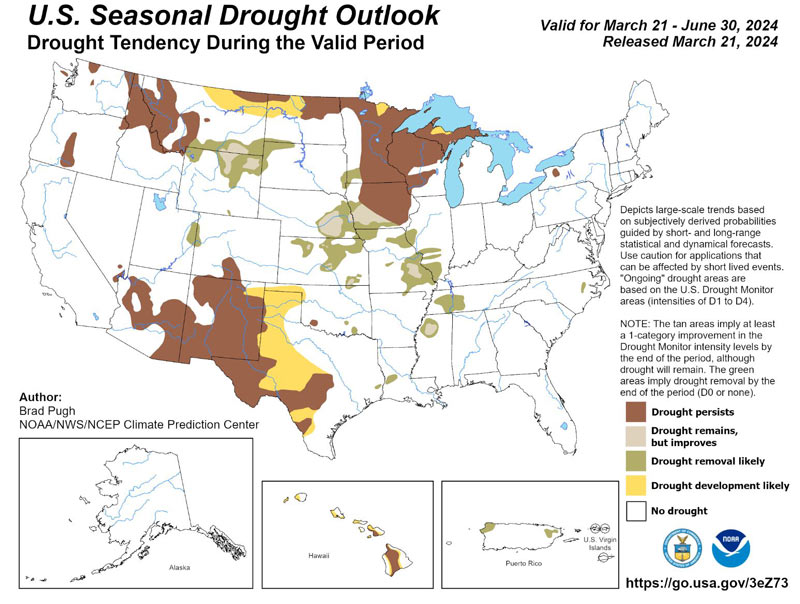
Spring Outlook for drought, temperature and precipitation
For April through June, above-average temperatures are likely to persist across much of the U.S. The greatest chance for above-average temperatures is in the Great Lakes region, the Pacific Northwest and Northwest Alaska, though most of the continental U.S. and Alaska have elevated odds of above-average temperatures.
Precipitation is slightly favored to be above average in portions of the central Plains, the southeastern U.S. and in southern Alaska. Parts of the Pacific Northwest and Southwest, meanwhile, are most likely to see precipitation below the seasonal average.
Moderate to exceptional drought conditions currently exist across less than 20% of the U.S. and Puerto Rico, a marked improvement from last year, as El Nino-fueled rain fell this winter across the Gulf Coast region. Drought conditions are likely to continue improving in the southeastern U.S.; however, the drought is likely to persist or even expand through portions of the Rocky Mountains and the Great Plains.
There is an 83% probability that ENSO Neutral conditions, neither El Nino nor La Nina, will return by the April-May-June 2024 timeframe. However, El Nino is expected to continue impacting weather patterns in the U.S. into the spring. A La Nina Watch issued by the Climate Prediction Center remains in effect — meaning La Nina conditions could return to the equatorial Pacific within six months.
“Our scientists at the Climate Prediction Center observed one of the strongest El Nino events on record during the winter of 2023-2024,” said Jon Gottschalck, chief of the Operational Prediction Branch from NOAA’s Climate Prediction Center. “But a quick transition to La Nina — the cool phase of ENSO — is possible as early as the first part of summer.”
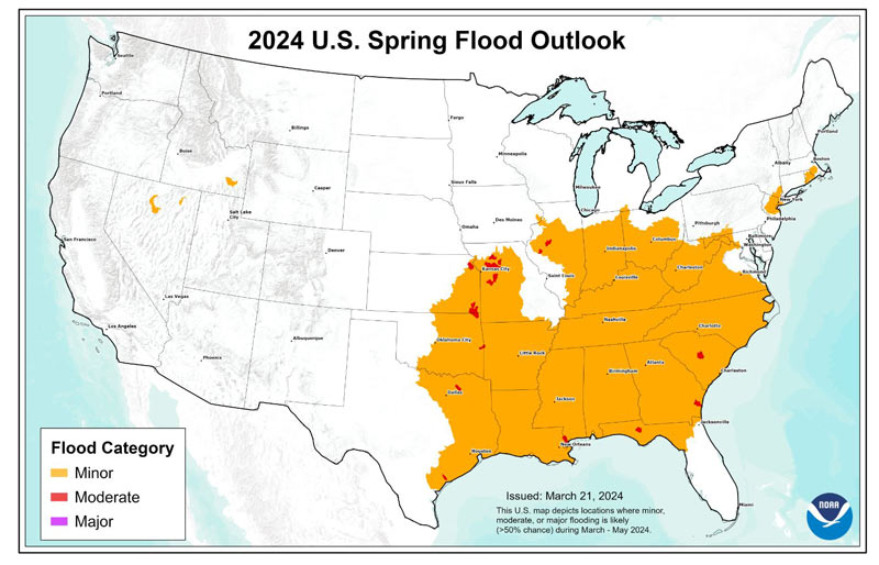
Spring flood risk
The overall threat of significant flooding this spring is low due to above-normal temperatures and historically-low snowpack. Moderate flooding is expected in climatologically flood-prone areas of the Midwest and South. The overall lack of snowpack and significant winter precipitation, coupled with the current outlook, suggests that low flow conditions may return to main stem rivers in the Greater Mississippi River Basin later this year.
“This is the first Spring Outlook since 2021 with no population expected to be impacted by major flooding," said Ed Clark, director, NOAA’s National Water Center. “Of growing concern will be the potentially low flows on the Mississippi River this summer into fall due to well-below snowpack and precipitation in most of the Northern Plains and Midwest. This could have potential impacts on those navigation and commercial interests that depend on water from the Mississippi River.”
Approximately 133 million people are at risk for flooding in their communities, with roughly 400,000 at risk for moderate flooding. NOAA’s National Hydrologic Assessment, issued by the National Water Center, evaluates a number of factors, including current conditions of snowpack, drought, soil saturation levels, frost depth, streamflow and precipitation.
NOAA’s Office of Water Prediction, which houses the National Water Center, has a number of exciting water initiatives on the way this year. A week from today, the National Water Prediction Service website is scheduled to launch, which will centralize water-related products and services by combining local and regional forecast information with new national level capabilities. The National Water Prediction Service — directed by the Flood Level Observation, Operations, and Decision Support (or FLOODS) Act of 2022 — is envisioned as the gateway to all NWS water information.
Last fall, NOAA’s Office of Water Prediction unveiled its Flood Inundation Mapping services, which provide actionable information to emergency and water managers to prepare for and respond to flood impacts. It provides a real extent of flow-over areas in Geospatial Information System (GIS) format on an hourly basis, as well as a five-day flood inundation forecast. These new flood inundation mapping services — supported by the Bipartisan Infrastructure Law — initially launched in Texas and parts of the Northeast and Mid-Atlantic, are expanding to cover 30% of the U.S. population by this fall, including much of the Ohio and Mississippi River Valleys, the Mid-Atlantic, the Pacific Northwest, Puerto Rico and the U.S. Virgin Islands.
About NOAA Outlooks
NOAA’s Spring Outlook highlights weather, drought and flood predictions for the April through June period, helping to build a more weather and climate-ready nation. NOAA produces seasonal outlooks to help communities prepare for weather and environmental conditions that are likely during the coming months to minimize impacts on lives and livelihoods.
Heavy rainfall at any time can lead to flooding, even in areas where the overall risk is considered low. Rainfall intensity and location can only be accurately forecast days in the future, therefore flood risk can change rapidly. Stay current with flood risk in your area with the latest official watches and warnings at weather.gov. For detailed hydrologic conditions and forecasts, go to water.weather.gov.
Source: NOAA