
California and National Drought Summary for May 5, 2026
Summary
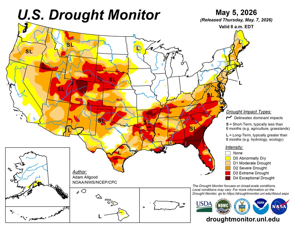
May 7, 2026 - Widespread soaking rains fell across Texas and the Deep South, bringing a much needed moisture boost to these drought stricken areas. While sufficient to ease drought conditions across portions of Texas, the lower Mississippi Valley, and the Tennessee Valley, drought conditions remained mostly unchanged across southeastern Alabama, Georgia and northwestern Florida, where soil moisture and streamflows remain extremely low. Lighter rainfall also overspread the Northeast, which, combined with cooler temperatures helped slow the advancement of drought, and improved drought conditions in Maine. Where lighter accumulations occurred, there was slight expansion of drought and abnormal dryness across portions of the mid-Atlantic, Hudson Valley, and southeastern New England. Cooler temperatures and mostly dry weather overspread the Plains and Midwest. While drought conditions continued to expand across the Plains, the drier weather was mostly welcome across the upper Midwest and Corn Belt, allowing fieldwork to progress. Hot, dry weather promoted degradation across Arizona and northwestern Washington, while late season moisture across northern California did little to change the meager snowpack conditions.
Northeast
Light to moderate precipitation overspread the Northeast region during the past week. The highest accumulations fell across Maine, resulting in some modest improvements to drought and abnormal dryness. Elsewhere, accumulations tended to be higher along and west of the mountains, and lighter (less than 0.5 inch) across the drought areas of the mid-Atlantic and southern New England. Cooler than average temperatures lowered evapotranspiration rates, which helped to stave off more widespread degradation. Drought indices at multiple time scales, including the SPI, supported drought expansion across the Delmarva peninsula. Abnormal dryness expanded across portions of the Hudson Valley and southeastern Massachusetts, while drought intensified in southeastern New Hampshire.
Southeast
An active weather pattern brought widespread heavy rainfall and thunderstorms to the Deep South, providing a much needed moisture boost to drought stricken areas. Total accumulations over the 7-day period topped 2 inches across much of Mississippi and Alabama, southern Georgia, and the western Florida Panhandle, and in some locations were significantly higher. The rainfall eased drought conditions across portions of Mississippi and northern Alabama, though widespread severe to exceptional drought continues. While beneficial, the rainfall did little more than stabilize conditions further east, across much of Georgia and northern Florida, where soil moisture and streamflows remain very low. No change in the drought depiction occurred in these regions, and more sustained rainfall would be needed to begin easing drought conditions. Lighter precipitation fell across the Florida peninsula, where drought conditions slowly expanded. Drought conditions remained stable in South Carolina, but drier conditions across North Carolina and Virginia resulted in some expansion of drought and abnormal dryness.
South
Following last week's beneficial rainfall, additional rain overspread much of Texas and Louisiana over the last several days, sparking additional drought reductions. Rainfall across central and western Texas eased drought across the upper Rio Grande Valley as well. Despite the beneficial rainfall, widespread severe to exceptional drought continues across the South Region, and it will take a sustained series of heavy precipitation events to begin any widespread easing of impacts. The beneficial rainfall missed the Texas Panhandle and western Oklahoma, where poor conditions continue to affect rangeland and winter wheat. Drought conditions also expanded across Arkansas.
Midwest
Following a period of sustained wetness across the region, drier conditions overspread the Midwest over the last 7 days. Unseasonable cold reduced evapotranspiration rates, and the pause in precipitation was mostly welcome for fieldwork activities that were delayed by the frequent storm systems. Impacts from drought and abnormal dryness eased across northern Minnesota and along the southern Indiana and Illinois border. Slight degradations were noted across southeastern Missouri and right along the Ohio River in south-central Indiana, as these regions missed out on some of the prior precipitation.
High Plains
Light to moderate precipitation overspread much of the High Plains, with the heaviest accumulations (0.5 - 1.5 inch) falling across central Colorado, including late season snow across the higher elevations. This precipitation resulted in some drought reduction across central Colorado. Across the rest of the Plains, however, the moisture was not sufficient to engender substantive improvements. Despite cooler temperatures lowering evapotranspiration rates, some degradation occurred across Kansas and Nebraska, and far western North Dakota.
West
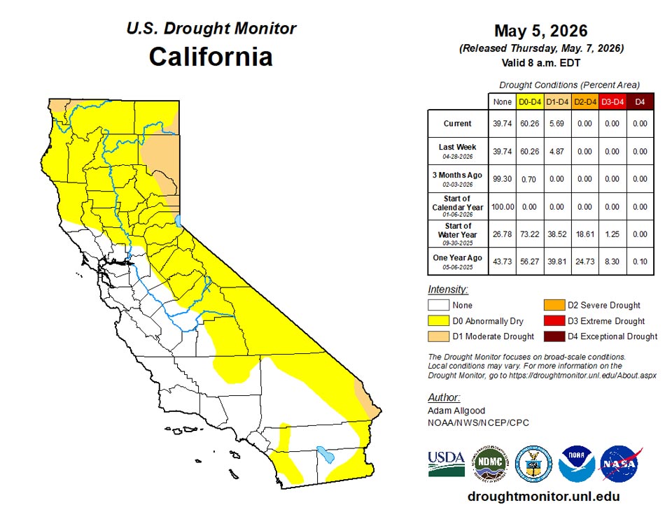
Outside of northern California, where late season moisture provided a boost to short-term streamflows and soil moisture but did little to change the unusually low snow cover across the northern Sierras, seasonably dry weather overspread most of the West. Recent moisture eased drought conditions across far western Montana. While little change to the drought depiction occurred across the West, hot, dry conditions exacerbated impacts across Arizona, resulting in some substantial degradation. Short term dryness also increased across northwestern Washington, resulting in expansion of D0.
Caribbean
No drought or abnormal dryness is currently in place across Puerto Rico. Some portions of the island have been experiencing drier conditions in recent weeks, and will have to be monitored into the early summer months.
Little to no precipitation fell across the U.S. Virgin Islands this week. St. Croix recorded between 0.13 inches to trace amounts. Similarly, St. John recorded 0.3 inches and St. Thomas recorded only trace amounts of rain. The Adventure 28 Well (St. Croix) recorded water depth of 20.72 ft. as of this week. This is 0.2 feet lower compared to last week and 3.56 feet lower compared to last year. The Susannaberg DPW 3 Well (St. John) recorded a water depth of 13.44 feet as of this week. This is 0.2 feet lower compared to last week and 3.63 feet lower compared to last year. The Grade School 3 Well (St. Thomas) has a water depth of 7.64 feet as of this week. This is 1.7 feet lower than last week and 2.77 feet lower compared to last year. Despite little-to-no rainfall, short-term SPI values are showing mostly neutral conditions, leaving all islands free of abnormal dryness or drought.
Pacific
Following above-normal precipitation across much of the state during April, coverage of abnormal dryness reduced across much of Alaska. Some D0 remains in the Kenai peninsula and the vicinity of Anchorage, where orographic effects reduced the amount of precipitation that fell.
Conditions across Hawaii's Big Island continue to improve, and vegetation has greened up over the past few weeks. Based on this assessment, the small remaining area of moderate drought was removed.
Rain was mixed across the Republic of the Marshall Islands. The islands of Jaluit and Majuro received adequate rainfall with 4.32 and 2.06 inches of rain this week, respectively. Kwajalein and Ailingalapalap saw 1.82 and 1.98 inches respectively, while Utirik, Wotje and Mili received less than half an inch of rain this week (0.31”, 0.3” and 0,1”). Despite some islands receiving little precipitation, decent precipitation during the prior weeks kept all islands free of abnormal dryness or drought.
The Federated States of Micronesia received heavy precipitation across most island, with some islands experiencing over 4 inches of precipitation. This heavy precipitation led to Lukunor abnormally dry conditions being improved to no dryness. Ulithi received 0.78 inches of rain this week and remains in abnormal dryness. Yap, despite receiving 4.39 inches of rain, remains in abnormal dryness due to poor precipitation over the previous weeks. Woleai (1.42”), Chuuk Lagoon (5.7”), Nukuoro (5.28”), Kapingamarangi (2.56”), Pohnpei (5.4”) and Kosrae (5.51”) all remain free of abnormal dryness.
The Republic of Palau remains abnormally dry with Koror recording 1.4 inches of rain this week following a dry April.
The Marianas Islands saw a mix of light and moderate precipitation this week. Guam saw a mix of decent to good precipitation with Dededo recording 0.31 inches, Agat with 1.62 inches and the airport 1.40 inches of rain this week. Saipan and Rota received 0.51 and 0.32 inches respectively. While the prior two weeks saw poor precipitation, well above normal precipitation from the typhoon has mitigated some of this dryness though Rota still has several weeks with missing data. Tinian data is missing.
American Samoa experienced wet week, with Pago Pago receiving 3.45 inches of rain. Additionally, the Siufaga and Toa Ridge received 2.64 inches and 2.62 inches of rain this week, respectively. American Samoa will remain free of drought and dryness.
Looking Ahead
During the next 7 days, an active pattern is favored to continue across the Southeast, with heavy rainfall (2 - 7 inches) possible along a swath from eastern Texas through southern Alabama. These rains would continue to bring drought relief and also a threat of severe weather. Lesser accumulations are favored across Georgia and Florida, which may limit the extent of any improvements. Widespread precipitation is also favored along the Ohio Valley and across the eastern seaboard, with the greatest potential for relief across the Northeast. Somewhat drier conditions across the mid-Atlantic may limit the potential for drought improvement. Light accumulations forecast across the Plains may do little to ease drought conditions, while another week of seasonable dryness is forecast across the West. Above-average temperatures across the West favor an acceleration of snowmelt, which may bring short term reservoir boosts but leaves the water supply even more short as summer approaches. Below-average temperatures are favored for the eastern half of the CONUS.
During the 8-14 day period, above-average temperatures are favored for much of the lower-48, with near normal temperatures forecast for the Northeast. Above-average precipitation is forecast for the southern tier, with the highest probabilities across Texas, eastern New Mexico, and Louisiana. A slight tilt towards above-normal precipitation extends across the Great Lakes Region into the Northeast, while below-average precipitation is favored for the northern Rockies.
Author(s):
Adam Allgood, NOAA/NWS/NCEP/CPC
Lindsay Johnson, National Drought Mitigation Center
Dryness Categories
D0 Abnormally Dry—used for areas showing dryness but not yet in drought, or for areas recovering from drought.
Drought Intensity Categories
D1 Moderate Drought
D2 Severe Drought
D3 Extreme Drought
D4 Exceptional Drought
Drought or Dryness Types
S Short-term, typically less than 6 months (agriculture, grasslands)
L Long-term, typically more than 6 months (hydrology, ecology)
SL Area contains both short- and long-term impacts
Source: National Drought Mitigation Center