
California and National Drought Summary for June 16, 2026
Summary
June 18, 2026 - The heaviest precipitation this week occurred across the Midwest and southern Plains. Flooding rains developed from south Texas into the Gulf Coast region during and beyond the period considered in this week's analysis. Portions of Illinois and Indiana recorded precipitation totals 4–5 inches above normal. Over the past several weeks, persistent rainfall across the Midwest and central to southern Plains has contributed to widespread drought improvement.
Temperatures were near to above normal across much of the country. The coolest conditions were observed from the central Plains into the northern Rocky Mountains, where portions of Montana and Wyoming averaged 4–6 degrees below normal. In contrast, the East Coast—particularly New England—as well as much of California and southern Nevada, experienced above-normal temperatures. Parts of New England recorded departures of 8–10 degrees above normal.
Northeast
Warm temperatures dominated the region this week. Areas from eastern Massachusetts into Maine experienced temperatures 8–10 degrees above normal, with locally higher departures. Much of West Virginia, western Pennsylvania, western New York, and portions of New England also received above-normal precipitation.
Rainfall in Maine allowed for improvements to moderate drought across much of the state. However, moderate drought expanded in Massachusetts, Connecticut, and eastern New York, while severe drought now encompasses all of Long Island. Extreme drought expanded farther north in Delaware and into additional areas of eastern Maryland. The wet week also allowed drought conditions to ease across portions of western Maryland and West Virginia.
Southeast
Precipitation was uneven across the region this week. Georgia received the most widespread rainfall, with portions of central and northern Georgia recording above-normal precipitation. Near-normal precipitation was common across much of the region, although parts of Florida and southern Alabama were below normal for the week.
Most of the Southeast experienced near- to above-normal temperatures, with the largest departures of 6–8 degrees above normal occurring across North Carolina and Virginia. North Carolina remains the state with the most significant drought degradation, particularly across central portions of the state. Extreme and exceptional drought expanded this week, and much of the state is reporting streamflows near record-low levels.
Widespread precipitation supported continued drought improvement in Georgia, where drought intensity decreased across much of the state and only a few counties remain in extreme drought. Targeted improvements were also made in northern South Carolina and western North Carolina, where recent rainfall provided relief. Conditions were largely unchanged in Virginia this week, as recent rainfall helped slow ongoing degradation. Severe drought improved in portions of northern Virginia, while extreme drought expanded slightly across southern sections of the state.
Florida continues to present a complex picture. Coastal areas along the Atlantic side of the state, as well as much of southern Florida, remained in an active rainfall pattern this week. A strong long-term hydrologic drought signal persists, but most other drought indicators continue to improve gradually. These improvements supported isolated drought reductions across portions of southern Florida.
Lake Okeechobee remains more than 2 feet below normal and continues to lose more water through outflows than it receives through inflows. Several areas within the Everglades remain without standing water, and burn bans are still in effect in several counties.
Conditions were fairly steady this past week in Alabama, with only minor drought improvement in the far northern part of the state and along the Georgia border. However, summer heat is already showing signs of pressure on streamflows, especially in the southern part of Alabama.
Midwest
The Midwestern states continue to experience an active pattern lately, with another week of extensive rainfall and several severe weather episodes from Missouri and Iowa, east into Michigan and Ohio. As such, more drought relief occurred from northeastern Missouri through northern Illinois. All of Ohio and Indiana are free of any abnormally dry or drought conditions, with most of Michigan experiencing the same lack of dryness, except for the far western parts of the Upper Peninsula.
Northern Illinois and central Wisconsin saw the most widespread drought relief as a result of widespread areas of 2-4 inches or more of rainfall over the past week. Other big winners receiving heavy rainfall include southeastern Iowa with 2-5 inches of rainfall. Northern Missouri had the heaviest totals in the 5-10 inch range, wiping out the last remaining stand of abnormal dryness over the northeast part of Missouri. Long-term severe to extreme drought remained in the bootheel of Missouri, where long-term signals still reflect substantial rainfall deficits.
Meanwhile in Kentucky, the northern and western parts of the state experienced 1 to locally 4 inches of rainfall, helping to whittle back moderate to severe drought coverage. However, eastern Kentucky has not fared so well, with short to long-term rainfall deficits continuing to accumulate. A new area of extreme drought has been introduced this week where hydrological impacts are being felt in the Kentucky River and Big Sandy watersheds. Low streamflow and water supply issues are already impacting eastern Kentucky at a level that would be concerning even later in the summer.
Other areas of drought expansion in the Midwest region occurred in northern Minnesota and northern Iowa, where long-term, persistent rainfall deficits continue to be a concern. In northern Minnesota, severe drought has been expanded north-northeastward toward the Canadian border to reflect the persistent and intensifying drought signal across the northern part of the state. While southern and eastern Iowa has been experiencing substantial rainfall, the northern and western part of the state has been persistently dry. The lack of rainfall this past week in north-central Iowa warranted the introduction of moderate drought just south of the Minnesota border, according to a local agriculture extension report.
High Plains
Across the High Plains states, drought continues to persist across western Kansas and eastern Colorado. The most severe and exceptional drought areas extend from eastern Wyoming into western and northern Nebraska and far southern South Dakota. Continued lack of rainfall and warmer-than-normal temperatures led to worsening drought conditions in the plains of eastern Colorado and small portions of northwestern Kansas. Exceptional drought was expanded across three counties in the Nebraska panhandle, where pastures and dryland wheat conditions are the poorest seen in decades, as a result of the record warm, dry winter followed by meager spring rainfall. The agricultural impacts in western Nebraska were confirmed by drought indicators spanning the last 6-12 months.
Other areas of degradation occurred this past week over North Dakota, especially the western half of the state. Moderate drought expanded southward along the Montana border as dry conditions intensified in western North Dakota. Abnormal dryness was introduced from southwest to north-central North Dakota due to recent drier-than-normal conditions.
The only improvements in the High Plains region are in central and eastern Nebraska. A couple swaths of 2-4 inches of rain fell this past week along the Interstate 80 corridor and into the southeastern part of Nebraska, which is presently free of any drought or abnormal dryness.
South
Across the southern states, many areas experienced widespread and substantial rainfall of 2–6 inches over the past week, especially southern and eastern Texas, eastern Oklahoma, northern Arkansas, northern Mississippi, and western Tennessee. Most areas of the deep southern states experienced drought improvement from all this rainfall. The only exception is in northeastern Tennessee, where drought degradations were made to the northwest of Knoxville due to worsening drought indicators.
The northeastern portion of the Texas Panhandle saw 2–4 inches rainfall over an area of exceptional drought, helping to relieve drought conditions with a small downgrade to extreme drought there. However, for the most part, extreme to exceptional drought conditions persisted across the Texas and Oklahoma panhandles, and much of western Oklahoma. Despite weekly rainfall of 2 inches or more along the periphery of Arkansas, severe to exceptional drought continued to persist in much of the state due to the long-term rainfall deficits of the past several months.
The recent appreciable rainfall over eastern Oklahoma, combined with more heavy rains this past week, led to a large removal of abnormal dryness from Texas to southwestern Missouri. Widespread heavy rainfall of 2–6 inches or more led to more drought coverage and intensity reduction across southern and eastern Texas, central Louisiana, and parts of western Mississippi. Drought relief also extended into western and northwestern Tennessee, representing the eastern extent of this week’s large area of heavy rainfall in the South.
West
There was not widespread precipitation across the region this week. However, portions of western Oregon and Washington, Arizona, northern Idaho, New Mexico, southern Montana, southern Utah, and northern Wyoming recorded above-normal precipitation.
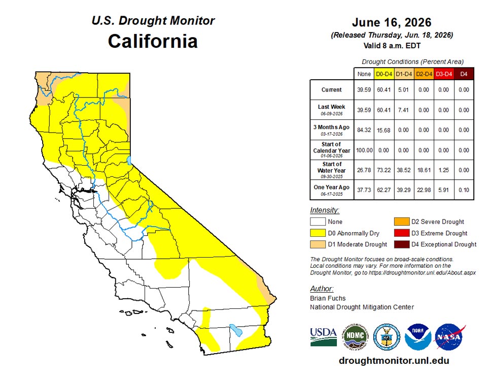
Temperatures were mixed, with below-normal readings across northern portions of the region and above-normal temperatures farther south. The warmest conditions occurred in California, Nevada, and Arizona, where departures of 6–8 degrees above normal or greater were widespread.
Drought degradation occurred across eastern Oregon, where moderate drought expanded. Moderate, severe, and extreme drought also expanded across much of southern Idaho and into western Montana, while extreme drought increased in coverage across central Wyoming.
Several weeks of wetter-than-normal conditions in New Mexico allowed for improvements to extreme drought across northeastern and southern portions of the state, although slight expansion occurred in northern areas. Improved short-term moisture conditions in eastern Utah and western Colorado supported reductions in extreme drought, while degradation occurred across central and eastern Colorado.
The impacts of a dry winter and below-normal snowpack continue to affect Colorado and other parts of the region, where increasing numbers of waterways are experiencing low-flow conditions.
Caribbean
In Puerto Rico, continued drier-than-normal conditions allowed abnormally dry conditions to expand across additional portions of central and northern Puerto Rico, while moderate drought expanded in the southwest.
Dry conditions persisted across the U.S. Virgin Islands this week, with all locations remaining in short-term moderate drought. On St. John, Rafe Boulon/Windswept Beach reported no precipitation this week, continuing the streak of no reported rainfall this month. Groundwater levels at the Susannaberg DPW 3 well were 15.40 feet below the land surface on June 16; analysis shows that water levels have mostly declined since October 19, 2025 (when the level was 7.56 feet), despite a slight, temporary recovery in early February and mid-April. Over the past year, this groundwater level has dropped approximately 5.09 feet from the 10.31 feet reported on June 16, 2025. This localized dryness is backed up by the 1-, 3-, and 9-month SPI, which indicates dry conditions on the island, though the 6- and 12-month SPI timescales showed a more average signal.
Meanwhile, only a trace of rainfall was reported on St. Croix at Henry Rohlsen Airport this week, leaving the month-to-date total at 0.06 inches as of June 15. CoCoRaHS stations across the island have reported month-to-date totals between 0.23 and 1.40 inches. The depth to water at the Adventure 28 Well was 21.76 feet below the land surface on June 16, reflecting a steady and severe decrease over the past year. This is a drop of 6.99 feet compared to this time last year, when the groundwater level sat at 14.77 feet on June 16, 2025. Reflecting this prolonged deficit, all SPI timescales (1-, 3-, 6-, 9-, and 12-month) confirm prevailing dry conditions on St. Croix.
On St. Thomas, Cyril E. King Airport reported only a trace of precipitation during the month of June as of June 15. The depth to water at the Grade School 3 well was measured at 9.25 feet below the land surface on June 16. Groundwater levels here have been on a steady decline since April 20, 2026 (when the level was 4.13 feet), dropping 5.12 feet over the past 8 weeks; furthermore, this level is down 7.21 feet from the 365-day maximum of 2.04 feet recorded on October 19, 2025. SPI values confirm these emerging deficits, showing dry conditions at the 1-, 3-, 6-, and 9-month timescales, while the longer-term SPI timescale (12-month) for the island was unavailable.
Pacific
In Alaska, conditions have been quite dry across the mainland during the past several weeks. However, later-than-average snowmelt and below-normal temperatures have prevented significant impacts, with local ecosystems remaining stable and no immediate fire danger observed. No changes were made in Alaska this week.
No changes were made in Hawaii this week.
American Samoa remained free of drought or abnormal dryness this week as wet conditions returned to the islands. Pago Pago reported a weekly rainfall total of 2.03 inches, pushing the June month-to-date total to 3.50 inches as of June 15. Additionally, Toa Ridge and Siufaga Ridge reported weekly rainfall totals of 2.38 and 1.29 inches, respectively. Consequently, Pago Pago remains completely free of drought and abnormal dryness.
Precipitation was below normal over Palau this week, with the Koror COOP site reporting a weekly rainfall total of 1.46 inches, bringing its month-to-date total to 3.86 inches as of June 16. Although this is below the two-inch minimum threshold to meet water needs, Palau remains free of drought and abnormal dryness due to previously wet weather.
Conditions were drier than normal over most of the Mariana Islands this week. Rota and Guam reported weekly rainfall totals of 0.74 and 0.36 inches, respectively—below the islands’ one-inch minimum weekly threshold to meet water needs. Saipan received 0.31 inches this week, marking the seventh consecutive week where precipitation totals fell below the minimum threshold. As a result, Saipan was degraded to short-term abnormal dryness this week.
Conditions varied across the Federated States of Micronesia this week. Kapingamarangi and Nukuoro reported weekly rainfall totals of 3.35 and 2.69 inches, respectively, keeping these locations free of drought and abnormal dryness. Lukunoch, Yap, Pohnpei, Kosrae, Chuuk, and Woleai reported weekly rainfall totals of 1.50, 0.72, 0.67, 0.50, 0.43, and 0.19 inches, respectively. Although these totals were below the two-inch minimum weekly threshold, these locations remained free of drought and abnormal dryness due to previously wet conditions. Meanwhile, data for Pingelap, Fananu, and Ulithi were insufficient to make an assessment this week.
Dry conditions prevailed across most of the Republic of the Marshall Islands, where Wotje (1.40 inches), Mili (0.93 inches), Utirik (0.50 inches), and Jaluit (0.31 inches) fell below the two-inch minimum weekly threshold necessary to meet water needs, but these locations remained free of drought and abnormal dryness due to previously wet conditions. Ailinglapalap received 0.20 inches this week, marking the third consecutive week where weekly rainfall totals failed to meet the two-inch threshold. Consequently, Ailinglapalap was degraded to short-term abnormal dryness this week. Conversely, Kwajalein and Majuro reported 3.57 and 2.17 inches of rainfall this week, and both locations remained free of drought and abnormal dryness.
Looking Ahead
During the next 5–7 days, more heavy rainfall is expected in the Deep South, as a result of a Tropical Storm Arthur near the southeastern Texas coast as of this writing. Deep tropical moisture will stream northeastward from Arthur as it advances into the Southeastern states. This tropical rainfall will have the potential to produce more drought relief in southeastern Louisiana, Alabama, Georgia, and Tennessee. Current rainfall forecasts by the Weather Prediction Center also show the potential for several inches of rain from Oklahoma, Missouri, and Arkansas, eastward into the Ohio River Valley, with more severe weather potential in the Midwest region. Other areas of appreciable rainfall are forecast for parts of the Northeast and the eastern portions of the High Plains.
The Climate Prediction Center’s 6–10 day outlook shows that above-normal temperatures should prevail across much of the western U.S. and along the immediate Gulf coast into Florida. Below-normal temperatures are possible from the eastern portions of the High Plains, the Midwest, and into the Northeast states. Meanwhile, precipitation is projected to be above normal across much of the Midwest and High Plains, possibly extending into the Northeast states. Near-normal rainfall is anticipated across the South and Southeast in the 6-10 day outlook, with below-normal precipitation expected in most of the West.
Author(s):
Brian Fuchs, National Drought Mitigation Center
Rocky Bilotta, NOAA/NCEI
Dryness Categories
D0 Abnormally Dry—used for areas showing dryness but not yet in drought, or for areas recovering from drought.
Drought Intensity Categories
D1 Moderate Drought
D2 Severe Drought
D3 Extreme Drought
D4 Exceptional Drought
Drought or Dryness Types
S Short-term, typically less than 6 months (agriculture, grasslands)
L Long-term, typically more than 6 months (hydrology, ecology)
SL Area contains both short- and long-term impacts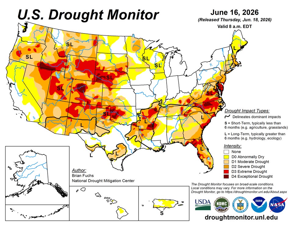
Source: National Drought Mitigation Center