
Thursday Evening: 1,177 Acres with 10% Containment, 376 Personnel
September 18, 2026 - The Dome Fire was reported on the morning of September 15, 2026. It is in the backcountry and located approximately 1/4 mile north of Chilnualna Falls and is visible from the Wawona Road (Highway 41).
Current Situation as of Thursday Evening:
Most activity on the Dome fire today was on the west and north flanks. Last night, spot fires were observed to the north of the fire due to gusty, ridge winds from the south and southeast. Some spot fires are in areas with no fire history while others are creeping and smoldering in the 2017 Empire Fire footprint. Visible smoke and good to unhealthy air quality conditions were observed today as the fire continues to burn through grass, brush, and timber fuels.
Ground crews continued constructing direct hand lines and looking for opportunities to tie the fire into previous fire footprints and granite features. Three more hotshot crews were flown into the fire today to reinforce work on the fire perimeter from the heel of the fire and on the east and west flanks. Air resources were again utilized today concentrating on strengthening the western flank.
Weather: TToday we had similar winds, but with cooler temperatures and mid-level clouds. Wind gusts up to 15-25 mph were expected. Due to significant elevation change over small distances near the fire, firefighters expect to see some moderation from the predicted forecast.
Evacuations
There are no evacuation orders or warnings in place. There are no immediate threats to infrastructures or developed areas.
Smoke Impacts / Air Quality: Dominant winds have been from the South and Southwest, which is pushing the smoke up and over the mountains into Nevada, however some smoke is expected overnight in the valleys within Yosemite National Park. View current Air Quality Monitoring at https://fire.airnow.gov/#7/38.532/-119.416
Temporary Trail Closure: Yosemite National Park is open and operating normally, with the following exception. The Chilnualna Falls trail, as well as the trails from the top of Chilnualna Falls toward Buena Vista and Crescent Lakes, are closed due to the Dome Fire (these lakes are reachable from the east.) The closed area also extends east of the Wawona Road from Wawona to Chinquapin, as seen on the public information map: https://arcg.is/z5HLC4.
Since 1916, the National Park Service has been entrusted with the care of our national parks. With the help of volunteers and partners, we safeguard these special places and share their stories with more than 318 million visitors every year. But our work doesn't stop there.
We are proud that tribes, local governments, nonprofit organizations, businesses, and individual citizens ask for our help in revitalizing their communities, preserving local history, celebrating local heritage, and creating close-to-home opportunities for kids and families to get outside, be active, and have fun.
| Total Personnel: | 386 |
|---|---|
| Size | 1,177 Acres |
| Percent of Perimeter Contained | 10% |
| Fuels Involved |
Standing closed canopy timber is producing active fire behavior and spotting, adjacent fuels become less continuous with scattered timber, brush, grass, and exposed granite hillsides. |
| Significant Events |
Active Fire Behavior was observed with isolated torching, flanking and creeping. |
| Planned Actions |
Direct and indirect suppression. Priorities, maintain southern heel and west flank, continue to utilize natural features on west flank moving North. Utilize retardant to support ground resources on West flank. Continue line construction on East flank utilizing natural features. |
|---|---|
| Projected Incident Activity |
12 hours: Expected spread to the north and north east with numerous spot fires, current fire behavior in those areas is creeping and smoldering in old fire footprints. 24 hours: Growth expected to the North and NE. South and West flanks are priority suppression flanks to maximize use of natural barriers. Multiple IHCs will construct direct and indirect handline with aviation support. 48 hours: Growth expected to the North and NE. South and West flanks are priority suppression flanks to maximize use of natural barriers. Crews will continue to assess opportunities to construct handline both direct and indirect utilizing natural barriers. |
| Current as of | Thu, 09/17/2026 - 22:21 |
|---|---|
| Incident Time Zone | Pacific Standard Time |
| Incident Type | Wildfire |
| Cause | Under Investigation |
| Date of Origin | |
| Incident Time Zone | Pacific Standard Time |
| Location | North of Wawona Dome |
| Incident Commander | California Complex Incident Management Team 3, Incident Commander Oscar Vargas. |
| Incident Description | The fire has a moderate rate of spread to the north and northeast. Firefighters have been utilizing natural barriers, and line has been secured on the south and west sides of the fire. The fire is deep in the wilderness and difficult to access due to steep, rugged terrain. |
| Coordinates | 37° 33' 58'' Latitude -119° 36' 82
'' Longitude |
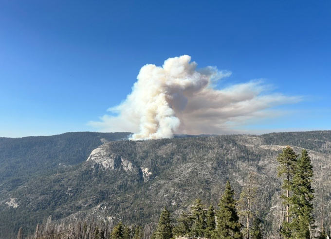
Dome Fire from Wawona Point, Yosemite National Park, 9-16-2026. NPS photo.
Source: INCIWEB