
October 12, 2026 - Yosemite National Park Dome Fire Monday Morning, October 12, Update: 6,788 Acres with 73% Containment.
Incident Update 5:27 A.M.
| Total Personnel: | 906 |
|---|---|
| Size | 6,788 Acres |
| Percent of Perimeter Contained | 73% |
| Estimated Containment Date | 10/17/2026 |
| Fuels Involved |
Timber (Litter and Understory) Brush (2 feet) Medium Logging Slash Red fir fuel type with montane shrub and brush understory interspersed with pockets of non-burnable fuels in granite rock outcrops. Fir trees are large diameter, over 100 ft. tall, and suffer from insect and disease mortality, leading to a significant snag component with large amounts of heavy dead and down coarse woody debris. Most active fire behavior has come from the dense, closed canopy red fir stands, where torching and isolated crown fire pockets have also contributed to spotting. Fuels in 2017 fire footprints have less closed canopy but contain significant dead and down with standing snags, increasing spotting potential. Surface spread rates are lower in the Empire Fire (2017) Footprint, but spotting continues to drive spread. Montane shrubs and brush in the understory are generally available to burn but are not at critical fuel moisture levels. Heavy dead and down fuels are dry, with fuel moisture in 1,000 hr. fuel around 12%. |
| Significant Events |
Minimal, Spotting, Creeping, Smoldering Due to a continued precipitation event, no fire behavior was observed. Large dead and down interior fuels continue may continue to smolder. |
| Current as of | Mon, 10/12/2026 - 08:27 |
|---|---|
| Incident Time Zone | Pacific Standard Time |
| Incident Type | Wildfire |
| Cause | Under Investigation |
| Date of Origin | |
| Incident Time Zone | Pacific Standard Time |
| Location | North of Wawona Dome |
| Incident Commander | California Complex Incident Management Team 4, Incident Commander Kyle Jacobson. |
| Incident Description | The fire has a moderate rate of spread to the north and northeast. Firefighters have been utilizing natural barriers, and line has been secured on the south and west sides of the fire. The fire is deep in the wilderness and difficult to access due to steep, rugged terrain. |
| Coordinates | 37° 33' 58'' Latitude -119° 36' 82
'' Longitude |
| Planned Actions |
Continue mop-up operations as necessary in all Branches and Divisions. Employ rotary-wing aviation assets to check fire from spreading outside of control lines. Backhaul supplies via aircraft and ground personnel on portions of controlled fireline. Ensuring personnel are prepared for the potential change in forecasted weather. |
|---|---|
| Projected Incident Activity |
12 hours: Precipitation anticipated for the duration of the night. Fire spread is not likely. Large dead and down fuels may continue to smolder. 24 hours: Precipitation is anticipated to continue over the fire area. Fire spread is not likely. Large heavy interior fuels may continue smoldering. 48 hours: Low pressure system and associated precipitation will begin to depart the fire area. Precipitation chance diminishes. Large heavy interior fuels may continue to smolder. Further fire behavior and spread will be dependent on the totality of the rain event in days prior. 72 hours: Gradual return to warm and dry weather. Smoldering in large dead and down fuels may continue. Further fire behavior and spread will be dependent on the totality of the rain event in days prior. Anticipated after 72 hours: Gradual return to warm and dry weather. Smoldering in large dead and down fuels may continue. Further fire behavior and spread will be dependent on the totality of the rain event in days prior. |
| Remarks |
Acreage revised due to more accurate mapping. |
| Weather Concerns |
Observed: Cooler, mostly cloudy conditions have developed across the fire area. Winds have been breezy to windy from the south. Some light precipitation amounting to a few hundredths of an inch or less is expected later this afternoon in this to evening. The freezing level is around 11k ft this afternoon. 12-Hour Overnight: Cold temperatures, low clouds, and fog are expected tonight. Some light precipitation is likely, mostly in the form of drizzle and freezing drizzle, and perhaps some light snow. Low temperatures are likely to fall into the mid-20s to the 30s. Breezy winds from the southeast are likely at higher elevations. The freezing level is likely to be between 6k and 8k ft. elevations. 24-72 Hour Forecast: Mostly cloudy conditions are likely to continue throughout the day Monday with some light precipitation likely, at times. Fog and drizzle with freezing levels 6k to 8k ft. are likely. High temperatures are likely to be only in the 30s to lower 40s Monday. Breezy southeast winds early Monday are likely to ease to light southerlies by afternoon. Skies will become mostly clear Tuesday night into Wednesday morning onward. Cold nights to mornings and cool days are likely Tuesday and Wednesday with widespread below freezing morning lows, mostly in the 20s, but lower in higher elevation bowls. Highs likely in the 30s to 40s Tuesday, and 40s and 50s on Wednesday. Extended (After 72 Hours): Dry conditions and mostly clear skies will return for the remainder of the week into the weekend with chilly overnight lows mostly in the 25 to 35 degree range and daytime highs of 55-65 degrees. |
|---|
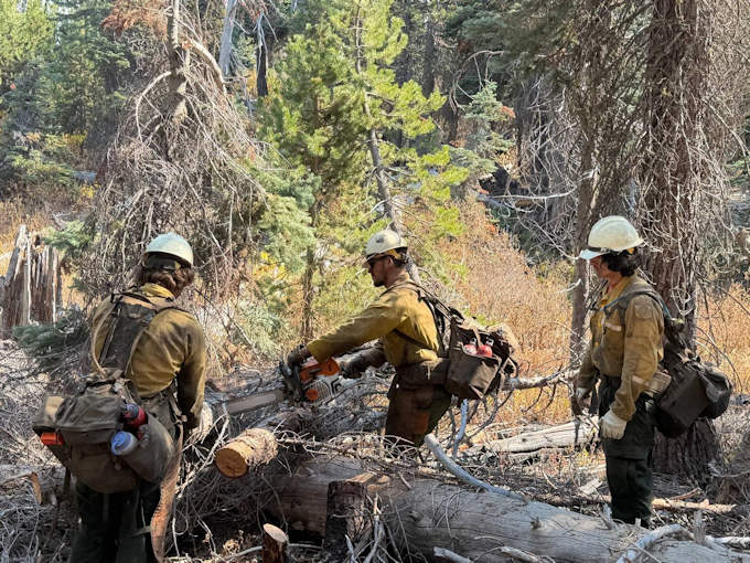
Dalton Hotshots performing chainsaw work on dead and down fuels in Division Mike.
Previous Information
Source: InciWeb