
Incident Update 7:28 A.M.
October 13, 2026 - Yosemite National Park Dome Fire Tuesday Morning, October 13, Update: 6,788 Acres with 86% Containment.
Incident Update 7:28 A.M.
THIS WILL BE THE LAST WRITTEN UPDATE UNLESS CONDITIONS CHANGE
OPERATIONAL UPDATE:
Progress on the Dome Fire continues, with no change to the perimeter in several days. Containment has increased to 86%. Fire activity remains minimal, and any visible smoke is coming from interior pockets of heat.
Firefighters on the east side will continue patrolling and mopping up today. Crews, mule trains, and helicopters will continue the task of removing hose and equipment from remote wilderness areas. Suppression repair work is underway to restore ground disturbed during firefighting operations, protecting sensitive natural and cultural resources and reducing the potential for erosion. Along secondary handlines, crews will pull berms back to match the natural terrain and scatter vegetation to help disguise the lines and limit water erosion.
California Interagency Incident Management Team 4 is scheduled to transfer command of the fire back to Yosemite National Park on Thursday, October 15.
WEATHER:
A warming and drying trend is expected as high pressure builds across the area, with mostly light winds. Highs Tuesday will likely be in the 40s. Temperatures are forecast to climb into the 50s and approach the 60s Wednesday and Thursday.
AIR QUALITY:
Smoke Outlooks with air quality and forecast information are available at:
https://fire.airnow.gov/#7/38.532/-119.416
CLOSURES:
Yosemite National Park is open and operating normally, with the following exceptions. Alder Creek Trail is open north to the Deer Camp Trailhead. Chilnualna Falls Trail is open from the trailhead east to Chilnualna Fall and Crescent Lake. All trails within the active fire footprint are currently closed, including all south and eastbound trails accessed from Glacier Point Road. Buena Vista Trail also remains closed at this time. The current Dome Fire Safety Closure Map is available at: https://www.nps.gov/yose/learn/management/closures.htm
FIRE RESTRICTIONS: Due to high fire danger, and to reduce the number of human-caused wildfires, fire restrictions are currently in effect below 8,000 feet in Yosemite National Park. Additional information is available at: https://www.nps.gov/yose/planyourvisit/firerestrictions.htm
Incident Update 6:37 A.M.
| Total Personnel: | 746 |
|---|---|
| Size | 6,788 Acres |
| Percent of Perimeter Contained | 86% |
| Estimated Containment Date | 10/17/2026 |
| Fuels Involved |
Timber (Litter and Understory) Brush (2 feet) Medium Logging Slash Red fir fuel type with montane shrub and brush understory interspersed with pockets of non-burnable fuels in granite rock outcrops. Fir trees are large diameter, over 100 ft. tall, and suffer from insect and disease mortality, leading to a significant snag component with large amounts of heavy dead and down coarse woody debris. Most active fire behavior has come from the dense, closed canopy red fir stands, where torching and isolated crown fire pockets have also contributed to spotting. Fuels in 2017 fire footprints have less closed canopy but contain significant dead and down with standing snags, increasing spotting potential. Surface spread rates are lower in the Empire Fire (2017) Footprint, but spotting continues to drive spread. Montane shrubs and brush in the understory are generally available to burn but are not at critical fuel moisture levels. Heavy dead and down fuels are dry, with fuel moisture in 1,000 hr. fuel around 12%. |
| Significant Events |
Minimal, Smoldering Due to a continued precipitation event no fire behavior was observed. Large dead and down interior fuels continue may continue to smolder. |
| Current as of | Tue, 10/13/2026 - 06:56 |
|---|---|
| Incident Time Zone | Pacific Standard Time |
| Incident Type | Wildfire |
| Cause | Under Investigation |
| Date of Origin | |
| Incident Time Zone | Pacific Standard Time |
| Location | North of Wawona Dome |
| Incident Commander | California Complex Incident Management Team 4, Incident Commander Kyle Jacobson. |
| Incident Description | The fire has a moderate rate of spread to the north and northeast. Firefighters have been utilizing natural barriers, and line has been secured on the south and west sides of the fire. The fire is deep in the wilderness and difficult to access due to steep, rugged terrain. |
| Coordinates | 37° 33' 58'' Latitude -119° 36' 82
'' Longitude |
| Planned Actions |
Continue mop-up operations as necessary in all Branches and Divisions. Employ rotary-wing aviation assets to check fire from spreading outside of control lines. Backhaul supplies via aircraft and ground personnel on portions of controlled fireline. Ensuring personnel are prepared for the potential change in forecasted weather. Implementing suppression repair in coordination with repair plan and READ’s. |
|---|---|
| Projected Incident Activity |
12 hours: Precipitation received with full overnight relative humidity recovery. Fire spread is not likely. Large dead and down fuels may continue to smolder. 24 hours: Lower chance of precipitation over the fire area. Fire spread is not likely. Large heavy interior fuels may continue smoldering. 48 hours: Warming and drying weather trend begins. Fuels will begin to dry out. Large heavy interior fuels may continue to smolder. Further fire behavior and spread will require several operational periods of drying. 72 hours: Warmer and drier weather continues. Fuels will continue to dry out. Large heavy interior fuels may continue to smolder. Fuels likely to remain at their saturation point and not sustain fire spread. Anticipated after 72 hours: Driest anticipated day of the period. Smoldering in large dead and down fuels may continue. Further fire behavior and spread will be dependent on the totality of the rain event in days prior and drying that occurs between. |
| Weather Concerns |
Observed: Mostly cloudy with fog, and rain and snow showers are being observed this afternoon. Temperatures have been chilly with highs in the 35-45°F range in and around the Dome Fire area. Winds have been light to slightly breezy and generally from the southwest resulting in a bit of a wind chill. 12-Hour Overnight: Rain and snow showers are likely to taper off by 2100 Local Time this evening. Mostly cloudy conditions with fog are likely to clear overnight thru the morning resulting in below freezing overnight lows ranging 15°F in the cold spots to 30°F. Some frost and light snow accumulation is likely. 24-72 Hour Forecast: A warming and drying trend with mostly light winds is expected as high pressure builds across the area. Highs likely in the 40s Tuesday are likely to warm in to the 50s to near 60°F Wednesday and Thursday, but chilly overnight lows mostly in the 15-35°F range are expected. Some enhanced, mostly easterly breezes are likely Thursday morning. Extended (After 72 Hours): Dry conditions and mostly clear skies will continue thru the weekend with chilly overnight lows mostly in the 20 to 40°F range and daytime highs 55-65°F. Enhanced, breezy, mostly easterly drainage winds are likely Friday morning, but light winds are otherwise expected. |
|---|
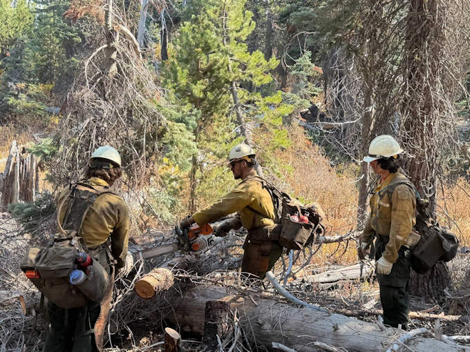
Dalton Hotshots performing chainsaw work on dead and down fuels in Division Mike.
Previous Information
Source: InciWeb