
October 15, 2026 - NOAA’s U.S. Winter Outlook, released today, shows how El Nino will likely influence the upcoming winter months (December 2026 to February 2027), with warmer-than-average temperatures expected across the northern U.S.; wetter-than-average conditions likely across the southern U.S., from California to Florida, and along the Eastern Seaboard; and drought improving for the majority of the country, including areas in the East, Southern Great Plains and Southwest.
“As we know from decades of observations, a very strong El Nino will likely bring a southward and eastward shift to the jet stream for the contiguous U.S., which tilts the odds toward stormier weather across the South,” said Ken Graham, director of NOAA’s National Weather Service. “While higher chances of rain and snow may bring relief to drought-afflicted areas, too much precipitation on dry soil can fuel destructive flash floods and mudslides. Now is the time for communities and individuals to plan ahead for the upcoming winter.”

Temperature Outlook
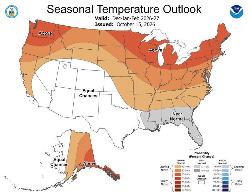
- Warmer-than-average temperatures are favored for northern California, the Pacific Northwest, Midwest, Mississippi Valley, much of the East, Alaska and for Puerto Rico / U.S. Virgin Islands.
- Near-normal temperatures are most likely for parts of the Southeast including Florida.
- Hawaii and much of the Southwest have equal chances of below-average, near-average or above-average seasonal mean temperatures.
Precipitation Outlook
- Wetter-than-average conditions are most likely across the southern tier, from the Southwest to the Southeast, and along the East Coast.
- Elevated odds for drier-than-average conditions for Hawaii, much of Alaska, the northern Mountain West, some areas in the Great Lakes and the western Pacific Islands.
- Areas in the Intermountain West, northern Plains, Ohio Valley and Puerto Rico / U.S. Virgin Islands have equal chances of below-average, near-average or above-average seasonal total precipitation amounts.

Drought Outlook
- Drought conditions are forecast to improve or end in the Southwest, Southern Great Plains, Southeast and parts of the East Coast.
- Drought conditions are favored to develop or worsen across parts of the northern Rockies, along with northeastern Oregon and eastern Washington.
Winter forecasting tools: What’s new this year
NOAA has also implemented upgrades to many of its winter weather products for the 2026-27 winter season:
- The National Weather Service’s Probabilistic Precipitation Portal is now operational. This platform enables users to view the low-end, expected, and high-end amounts of snow, ice and rain, as well as the probabilities of precipitation exceeding specific thresholds. Data are accessible through an interactive map, tables and graphics to assist local partners and emergency managers with decision support. Local graphics and probabilistic snow resources can be found online.
- The National Weather Service will implement the use of “Particularly Dangerous Situation” wording in select Blizzard Warnings and Ice Storm Warnings this season. This language will help forecasters alert partners and the public about high-confidence blizzards or ice storms of historic severity. These rare events typically pose exceptional threats by posing imminent danger to life and unprecedented disruptions to emergency services.
About NOAA's seasonal outlooks
NOAA’s seasonal outlooks provide the likelihood that temperatures and total precipitation amounts will be above-, near- or below-average, and how drought conditions are anticipated to change in the months ahead. The outlook does not project seasonal snowfall accumulations as snow forecasts are generally not predictable more than a week in advance. NOAA’s Weather Prediction Center updates its three-month outlook monthly. The next update will be available on November 19.
Stay current on winter weather risks in your area with the latest official watches and warnings at weather.gov. Visit weather.gov/safety for important winter preparedness information.
Source: NOAA