


Statistics
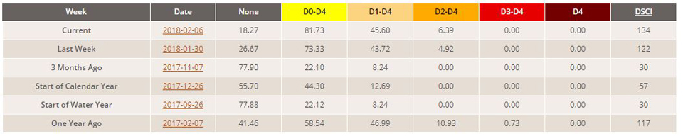
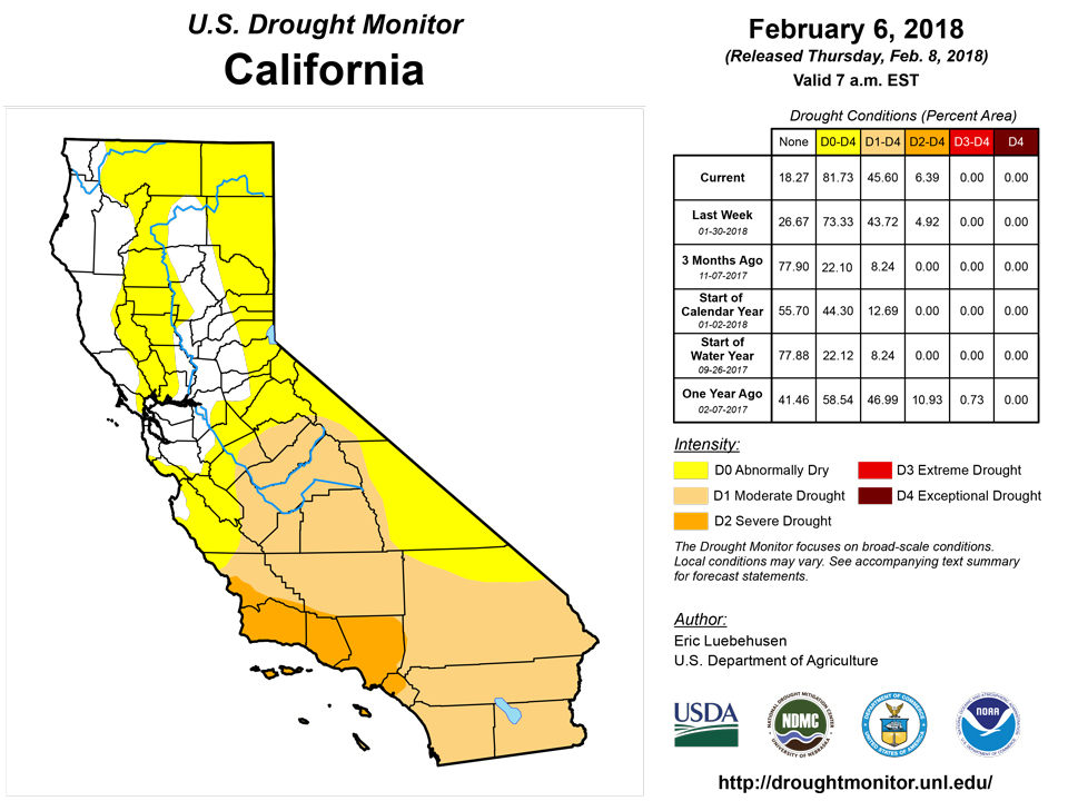
California and National Drought Summary for February 6, 2018
Summary
February 8, 2018 - During the 7-day period (ending Tuesday morning), near- to above-normal precipitation was observed from the interior Southeast into New England, while dryness intensified across the southern half of the Plains and much of the southwestern quarter of the nation. Drought continued to expand on the southern Plans, while a reduction in drought intensity and coverage was noted in parts of the south and east where rain and snow were heaviest. The situation across the western U.S. presented sharply diverging scenarios, with good season-to-date moisture supplies across the northern Rockies and Pacific Northwest in sharp contrast to intensifying drought and a lack of vital snowpacks across central and southern portions of the Rockies and Sierra Nevada.
Northeast
Seasonably cool, unsettled conditions prevailed across the Northeast. Precipitation was widespread, with rain falling in locales closer to the coast and snow reported further inland. In the Abnormal Dryness (D0) areas from Maine into Delaware, precipitation totaled 1 to 3 inches. There was also moderate to heavy precipitation (1-2 inches liquid equivalent) observed in west-central Maryland and environs. In these locales, D0 was reduced or eliminated. Despite the wet weather, significant 90-day precipitation deficits (locally less than 50 percent of normal) lingered in the core Moderate (D1) and Severe (D2) Drought areas. Furthermore, groundwater levels remained unfavorably low (25th percentile or lower) in the D2 areas of central Maryland.
Southeast
A second week of wet weather began lifting parts of the Southeast out of drought, though significant precipitation deficits lingered over the past 2 to 6 months. Several swaths of moderate to heavy rain (1-3 inches, locally more) were observed, with the main area of rainfall extending from central Alabama into central and northern Virginia, with a second smaller area of inch-plus totals encompassing southern Georgia and northern Florida. Reductions of Abnormal Dryness (D0) and Moderate, Severe, and Extreme Drought (D1, D2, and D3, respectively) were widespread, especially in locales where rain topped 2 inches during the preceding 7 days and two-week rainfall was in excess of 3 inches. Despite the recent wetness, 90-day precipitation remained a meager 50 percent of normal (or less) in the core D1 and D2 areas, with deficits topping 8 inches in the southern Appalachians and along the northeastern Gulf Coast. As a reference, the 90-day Standardized Precipitation Index (SPI) – which puts precipitation into a drought intensity equivalent – was still at or below D2 levels in large portions of the interior Southeast.
South
Rain in eastern portions of the region contrasted with intensifying drought across the southern Plans and environs. Rain totaled 1 to 3 inches (locally more) over central and eastern Mississippi, while two-week totals of 2 to 6 inches extended from southeastern Texas into central Mississippi. Despite the much-needed moisture, considerable longer-term deficits persisted in the Delta’s core Moderate and Severe Drought (D1 and D2) areas, with 90-day precipitation at or below 50 percent of normal (D2 equivalent or worse). Farther west, Extreme Drought (D3) expanded across much of northern Texas and western Oklahoma, with subsequent increases in D2 noted in central Texas and eastern Oklahoma. From Lubbock, Texas, northward into Oklahoma, little — if any — rain or snow has fallen over the past 90 days; the four-month Standardized Precipitation Index (SPI) was well below D4 levels (-2.0 or lower) in these locales. Despite the cooler season with minimal agricultural activity on the Plains, impacts were beginning to appear. In Oklahoma, the percent of winter wheat rated poor to very poor jumped from 10 percent at the end of November to 79 percent by the end of January, with 93 percent of the state’s topsoil moisture rated short to very short. In Texas, the lack of precipitation is reaching historic levels. According to the National Weather Service, February 7, 2018, marked the 117th consecutive day without measurable precipitation for Amarillo, shattering the previous mark of 75 days (records date back to 1892). In Lubbock, February 7 marked the 91st consecutive day without measurable precipitation, just 7 days shy of the 98-day benchmark. The situation on the southern Plains is rapidly becoming dire, and precipitation will be needed soon to prevent further expansion or intensification of drought.
Midwest
Cold but dry weather prevailed, with small increases in Abnormal Dryness (D0) and Moderate Drought (D1) noted in the driest locales. With much of the region encased in a shallow to moderate snow cover, changes were minor. However, increasingly dry conditions over east-central Illinois (less than 50 percent-of-normal precipitation over
the past 90 days) resulted in the expansion of D0. Similarly, D1 was expanded eastward from the Dakotas into west-central Minnesota to account very dry conditions over the past three to four months; 90-day precipitation was 10 to 50 percent of normal, and the 3- and 4-month Standardized Precipitation Index (SPI) was D2 equivalent or lower.
High Plains
Additional snow in the north and west contrasted with increasingly dry conditions in southern and eastern portions of the region. A continuation of the recent unsettled weather pattern in northeastern Colorado (30-day surplus of 1-2 inches, liquid equivalent) supported the reduction of Moderate Drought (D1). Conversely, a lack of precipitation over the past 90 days coupled with input from experts in the field led to an expansion of D1 in northeastern South Dakota and southeastern North Dakota. Of particular concern is this winter’s subpar snowfall to date; winter snowfall is important for agriculture (providing runoff to refill stock ponds, protects winter wheat from temperature extremes, provides topsoil moisture) and serves as early spring water supply for ecosystems as the snowmelt season approaches.
West
Favorable conditions in the north contrasted sharply with dry, warm weather in central and southern portions of the region. From the Pacific Northwest into the northern Rockies, the favorable start to the current Water Year continued, with additional rain and mountain snow (1-4 inches liquid equivalent, locally more) reported during the 7-day period. As of Tuesday, February 6, the Snow Water Equivalent (SWE) of mountain snowpacks was well above normal (50-100th percentile) from Washington into the northern Rockies, with surpluses extending southward into the east-central Rockies (just west of Denver, Colorado). Conversely, the SWE was approaching or at historical lows (25th percentile or lower, with many stations reporting no snow at all) from western Colorado and much of Utah southward into Arizona and New Mexico. Likewise, the lack of snow — due in part to unseasonable warmth — has raised the specter of re-intensifying western drought in the Sierra Nevada, southern Cascades, and Blue Mountains. The lack of snow is having an immediate impact, forcing some ski areas to close historically early. Furthermore, a significant portion of the western water supply is contingent on snowmelt, and the poor spring runoff prospects will place a higher-than-normal burden on reservoirs. Currently, reservoir supplies are mostly in good shape due to last year’s abundant rain and snow. Nevertheless, the overall lack of precipitation since the beginning of the current Water Year (October 1) is compounding the effects of very low SWE, with season-to-date precipitation tallying a meager 25 percent of normal or less from southern California into the Four Corners region. In many of the aforementioned areas, drought will rapidly expand and intensify if precipitation does not return soon.
Alaska, Hawaii, and Puerto Rico
A wet weather pattern continued in Hawaii, though some areas missed out. Kauai and Oahu's leeward areas have received enough rainfall to depict improvement from Abnormal Dryness (D0) and Moderate Drought (D1). On the Big Island, the Kona slopes have mostly been very dry; consequently, the D1 along the lower slopes was expanded and extended southward. In Alaska, D0 was reduced in eastern portions of the state to reflect improving mountain snowpacks and near- to above-normal precipitation during the current Water Year (since October 1). Puerto Rico remained free of Abnormal Dryness or drought.
Looking Ahead
A wintry mix will depart the East Coast at the beginning of the period, with this system having already provided much-needed rain and snow to many drought areas of the southern and eastern U.S. On this storm’s heels, a frontal boundary initially draped over the northern Plains and Corn Belt will be the focus for another round of rain and snow. As the front pushes south, a wave of low pressure will develop and move northeastward across the Atlantic Coast States during the weekend. As a result, moderate to heavy precipitation (1-2 inches, locally more) will provide additional drought relief from the Delta into the Mid-Atlantic and Northeast, with lighter showers expected over the Southeast. Despite the active weather pattern, dry weather will linger from the southern Plains into the Southwest. The NWS 6- to 10-day outlook for February 13 – 17 calls for warmer- and wetter-than-normal weather across the eastern third of the nation. Likewise, near- to above-normal temperatures are anticipated from the Plains to the Pacific Coast — save for chilly weather on the northern Plains — but unfavorable dryness will persist from the western Corn Belt and central Plains to the Pacific Coast States.
Author(s):
Eric Luebehusen, U.S. Department of Agriculture
Dryness Categories
D0 Abnormally Dry—used for areas showing dryness but not yet in drought, or for areas recovering from drought.
Drought Intensity Categories
D1 Moderate Drought
D2 Severe Drought
D3 Extreme Drought
D4 Exceptional Drought
Drought or Dryness Types
S Short-Term, typically less than 6 months (e.g. agricultural, grasslands)
L Long-Term, typically greater than 6 months (e.g. hydrologic, ecologic)
Source: National Drought Mitigation Center
