


 Lions Fire
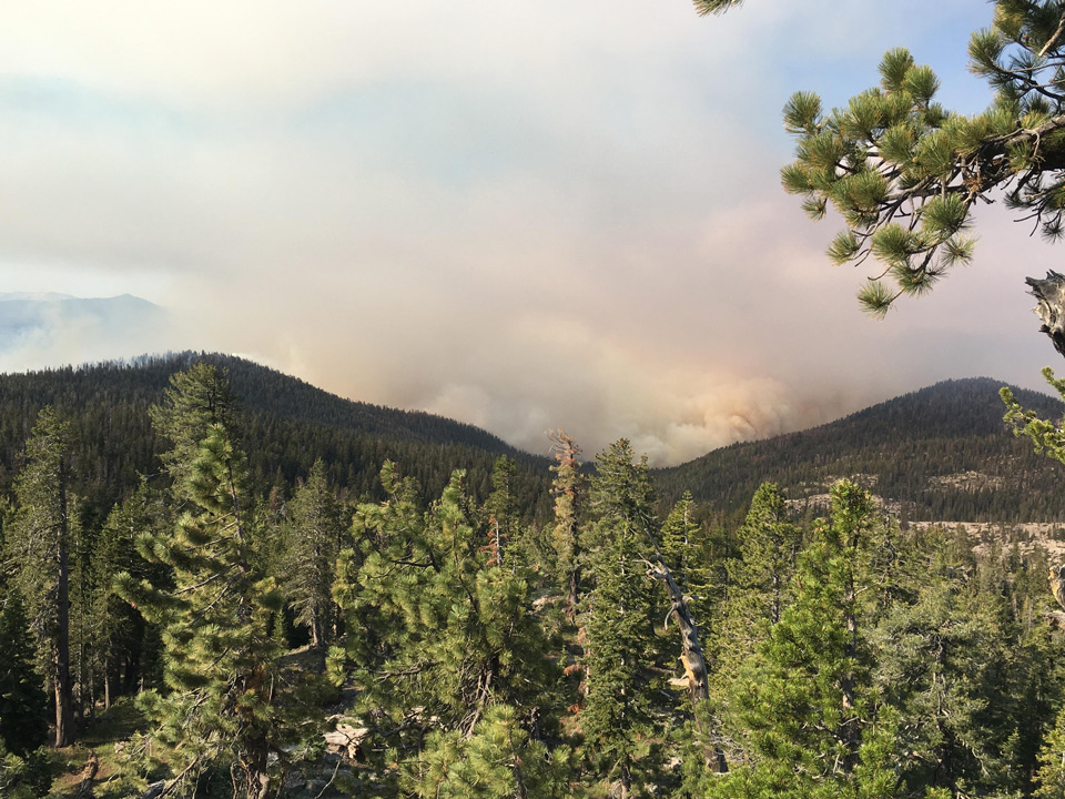
Credit: Sierra National Forest - Inciweb
Updated Map for June 26 Added Below
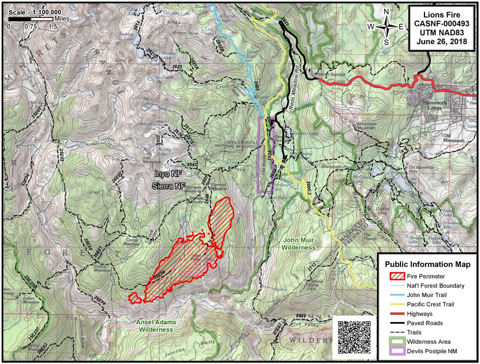
June 26, 2018 - The Lions Fire continues to burn in the Ansel Adams Wilderness area. Strong winds and dry conditions have resulted in the fire growing to 2,658 acres. The fire is burning in rugged and inaccessible terrain in the Stairway Creek drainage, north and west of the Middle Fork of the San Joaquin River.
Large areas of standing dead and down timber (red fir) are within and surrounding the burn area. Presently there is no threat to structures or public safety. All trails remain open at this time, including the Pacific Crest Trail and the John Muir Trail. Lateral trails leading into the fire area are being considered for closure in the near future. Hikers are advised to check the areas they are interested in going to before starting.
Firefighters are containing the spread by suppressing active burning and building direct and indirect fireline. The fire is being managed for multiple resource and protection objectives including suppression, air quality, firefighter safety and hazardous vegetation reduction. Because the fire is burning in designated wilderness, fire officials will be using MIST (Minimum Impact Suppression Tactics), such as using natural barriers for containment lines and minimizing line construction, only using hand construction. Additional resources have been ordered to assist in the implementation of fire objectives.
The communities near the fire can expect smoke impacts in varying degrees for at least the next week. Air quality and smoke forecasts will be available as the incident progresses.
There has been a Temporary Flight Restriction issued for a 5 mile radius around the fire. This does not impact flights landing at the Mammoth-Yosemite Airport.
To see smoke impacts in the area, visit webcams at Mammothmountain.com.
Source: Inciweb
Related information: Sierra National Forest Lions Fire Monday Evening Updates
Update: 7:52 P.M.
| Significant Events |
Moderate Flanking Isolated Torching Short-Range Spotting |
Update: 6:04 P.M.
Basic Information
| Current as of | 6/26/2018, 6:03:59 PM |
| Incident Type | Wildfire |
| Cause | Lightning Strike |
| Date of Origin | Monday June 11th, 2018 approx. 12:00 PM |
| Location | 7 miles southwest of Mammoth Lakes. |
| Incident Commander | Stephen Fillmore, Type 3 IC |
| Incident Description | The Fire Is Burning At Approximately 6000- 8000' In Red Fir (compact) Needle Cast And Brush. |
| Coordinates | 37.571 latitude, -119.118 longitude |
Current Situation
| Total Personnel | 266 |
| Size | 2,959 Acres |
| Estimated Containment Date | Saturday July 14th, 2018 approx. 12:00 AM |
| Fuels Involved |
Timber (Litter and understory) Brush (2 feet) |
| Significant Events |
Active Wind driven runs Group Torching Long Range Spotting |
Outlook
| Planned Actions |
Crews will continue to scout, construct, and burn out fire lines utilizing natural barriers to the extent possible. Utilize helicopter water drops to check fire in inaccessible terrain north and west of the San Joaquin River. |
| Projected Incident Activity |
Continued spread to West and Northeast especially in thermal belts with poor recoveries and in dry fuels. Downslope winds may push fire further south in the San Joaquin River. |
| Remarks |
1,883 acres on the Sierra National Forest; 1,076 acres on the Inyo National Forest. |
Current Weather
| Weather Concerns |
Hot and dry conditions continue into mid-week. An incoming low pressure center will increase winds Wednesday, similar to what occurred on Monday. Afternoon temps in mid-80s, RH in mid-teens, and afternoon winds SW 10-15, gusts to 35. |
Update: 2:08 P.M.
Basic Information
| Current as of | 6/26/2018, 2:07:41 PM |
| Incident Type | Wildfire |
| Cause | Lightning Strike |
| Date of Origin | Monday June 11th, 2018 approx. 12:00 PM |
| Location | 7 miles southwest of Mammoth Lakes. |
| Incident Commander | Stephen Fillmore, Type 3 IC |
| Incident Description | The Fire Is Burning At Approximately 6000- 8000' In Red Fir (compact) Needle Cast And Brush. |
| Coordinates | 37.571 latitude, -119.118 longitude |
Current Situation
| Total Personnel | 211 |
| Size | 2,658 Acres |
| Estimated Containment Date | Saturday July 14th, 2018 approx. 12:00 AM |
| Fuels Involved |
Timber (Litter and understory) Brush (2 feet) |
| Significant Events |
Active Wind driven runs Group Torching Long Range Spotting |
Outlook
| Planned Actions |
Crews will continue to scout possible fire lines utilizing natural barriers to the extent possible. Utilize helicopter bucket work to check fire in inaccessible terrain north of San Joaquin River. |
| Projected Incident Activity |
Continued spread to West and Northeast especially in thermal belts with poor recoveries and in dry fuels. Downslope winds may push fire further south in the San Joaquin River. |
| Remarks |
1,636 acres on the Sierra National Forest. 747 acres on the Inyo National Forest. |
Current Weather
| Weather Concerns |
Warming and drying trend in forecast through Wednesday or Thursday. Afternoon temps in the mid 80s, RH in mid-teens and afternoon winds 10-15 mph, gusts to 30. |
Update: 10:35 A.M.
Basic Information
| Current as of | 6/26/2018, 10:34:41 AM |
| Incident Type | Wildfire |
| Cause | Lightning Strike |
| Date of Origin | Monday June 11th, 2018 approx. 12:00 PM |
| Location | 7 miles southwest of Mammoth Lakes. |
| Incident Commander | Stephen Fillmore, Type 3 IC |
| Incident Description | The Fire Is Burning At Approximately 6000- 8000' In Red Fir (compact) Needle Cast And Brush. |
| Coordinates | 37.571 latitude, -119.118 longitude |
Current Situation
| Total Personnel | 211 |
| Size | 2,658 Acres |
| Estimated Containment Date | Saturday July 14th, 2018 approx. 12:00 AM |
| Fuels Involved |
Timber (Litter and understory) Brush (2 feet) |
| Significant Events |
Active Wind driven runs Group Torching Long Range Spotting |
Outlook
| Planned Actions |
Crews will continue to scout possible fire lines utilizing natural barriers to the extent possible. Utilize helicopter bucket work to check fire in inaccessible terrain north of San Joaquin River. |
| Projected Incident Activity |
Continued spread to West and Northeast especially in thermal belts with poor recoveries and in dry fuels. Downslope winds may push fire further south in the San Joaquin River. |
| Remarks |
1,636 acres on the Sierra National Forest. 747 acres on the Inyo National Forest. |
Current Weather
| Weather Concerns |
Warming and drying trend in forecast through Wednesday or Thursday. Afternoon temps in the mid 80s, RH in mid-teens and afternoon winds 10-15 mph, gusts to 30. |

