


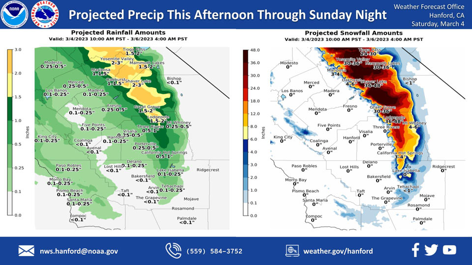
Projected Rainfall for Mariposa and Oakhurst 1.00" to 1.50"
Projected Snowfall for Mariposa: 3-4 inches
Projected Snowfall for Oakhurst: 4-6 inches
Projected Rainfall for Yosemite Valley: 1.50" to 2.00" Now 2.00" to 3.00"
Projected Snowfall for Yosemite Valley: 24-30 inches Now 30-36 inches
March 4, 2023 - The National Weather Service Hanford Office reports a storm system will be responsible for snow in the Sierra Nevada and adjacent foothills, as well as periods of rain in the San Joaquin Valley this afternoon through Sunday night.
Snow levels will start at around 4,000 feet this afternoon, before falling to about 2,000 feet Sunday.
Snow levels should drop to near 1,000 feet Sunday night.
The majority of this precipitation will fall tonight and Sunday morning.
Area Forecast Discussion
National Weather Service Hanford CA
132 AM PST Sat Mar 4 2023
.SYNOPSIS...
After a few days of dry but cold weather, a trough will move into
and begin impacting the area today through Sunday night. The
biggest impacts from this storm will be additional large amounts
of snow in areas that have already been inundated with snow. Storm
totals have increased and many northern mountain communities could
see up four feet of snow. Alongside high snow totals, the system
will bring rain to the San Joaquin Valley, with many areas seeing
a quarter to a half inch of rain through Sunday night. After this
storm moves out of the area on Monday morning, a break from
precipitation and warmer temperatures could occur, but confidence
in this is low due to model disagreement.
&&
.DISCUSSION...
After a much needed couple day break from precipitation, a trough
will bring even more precipitation, mostly snow, to northern
mountain communities that have already seen impressive snow
amounts within the last couple weeks. The system looks to begin
impacting these communities around 10am this morning and most
precipitation will fall Saturday afternoon through Sunday
afternoon. It will move out of the area completely by 4AM PST
Monday morning. Snow levels will start at 3500 feet on Saturday
afternoon before lowering to 2000 feet by Sunday morning and
lowering further to 1000 feet by Sunday night. Some low elevation
areas that could see a few inches of snow are Mariposa and
Oakhurst. High winds will accompany the snow, which has led to a
Winter Storm Warning valid from 10AM today to 4AM Monday,
including a southern expansion of the warning due to updated snow
totals.
Snow amount totals have risen, so here are the latest probabilities
that areas below will see 18 inches of snow or more:
Yosemite Valley and Shaver Lake: 80-90 percent
Tioga Pass and Mammoth Lakes: 40-50 percent
Grant Grove and Lodgepole: 50-60 percent
In addition to snow, the system will bring rain to
much of the San Joaquin Valley, of which most will fall again
between Saturday and Sunday afternoon. Much of the valley will see
between a quarter of an inch to a half inch of rain. Bakersfield
and the Grapevine are set to see less rain, up to a tenth of an
inch.
Once the system moves out of the area, it is possible we could see
a break from precipitation and warmer temperatures, with high
temperatures rising to the mid to high sixties by Saturday. Low
temperatures could also rise to the low forties by Saturday.
While this scenario would no doubt be appreciated, ensemble model
guidance cannot come to agreement on what will happen mid to late
next week, and therefore our forecasts at the moment are low
confidence.
&&
.AVIATION...
Mountain obscuration due to heavy snow in the Sierra could result
in MVFR to LFR conditions. Otherwise, VFR conditions will prevail
across Central California for the next 24 hours.
&&
.AIR QUALITY ISSUES...
ISSUED: 03/03/2023 14:40
EXPIRES: 03/04/2023 23:59
None.
&&
.CERTAINTY...
The level of certainty for days 1 and 2 is medium.
The level of certainty for days 3 through 7 is medium.
Certainty levels include low...medium...and high. Please visit
www.weather.gov/hnx/certainty.html for additional information
and/or to provide feedback.
&&
.HNX WATCHES/WARNINGS/ADVISORIES...
Winter Storm Warning from 10 AM this morning to 4 AM PST Monday
for CAZ318-320-322>331.
Source: NWS

