


Projected Rainfall for Mariposa and Oakhurst 3.00" to 4.00" Now 4.00" to 6.00"
Projected Rainfall for Yosemite Valley: 3.00" to 4.00" Now 4.00" to 6.00"
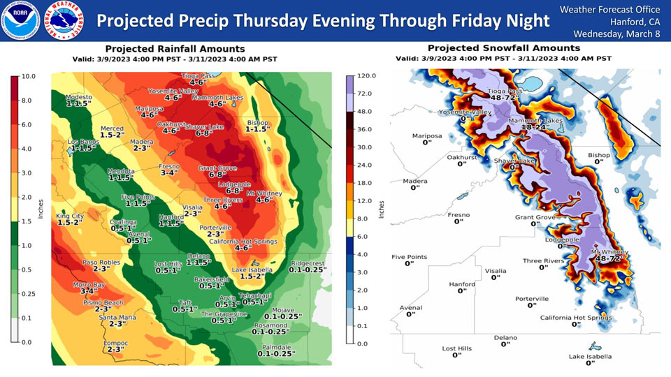
March 8, 2023 - The National Weather Service Hanford Office reports a strong storm system will impact Central California Thursday evening through Friday night, resulting in excessive rainfall in most of the San Joaquin Valley, the Sierra Nevada foothills, and the Sierra Nevada below 9,000 feet.
A Flood Watch is in effect.
The majority of this precipitation will fall Thursday night and Friday.
Area Forecast Discussion
National Weather Service Hanford CA
217 AM PST Wed Mar 8 2023
.SYNOPSIS...
Light snow is possible for the Sierra Nevada Wednesday morning,
with the system clearing out by the evening. A much stronger,
warmer, and wetter storm will then impact almost the entire CWA,
with large amounts of rainfall below 8000ft, which will cause
rapid snowmelt from 2000ft to 5000ft due to the increasing snow
levels. This may cause flooding concerns as the rain falls onto
the fallen snow. Another system may come through our area by
Monday, bringing more rain and high elevation snow.
&&
.DISCUSSION...
A shortwave trough will bring another round of light snow to the
central Sierra Nevada and foothills. This shortwave is coming off
of a larger trough in the main flow that has been over the
northern west coast for more than a week. After this shortwave
moves off and back into the main flow, a more laminar flow pattern
will take effect and bring in large amounts of moisture and warm
air from the tropical Pacific, resulting in a significant
Atmospheric River event. This will bring snow levels up to 8000ft
and cause large amounts of rain to fall in the valley and on the
mountains below 8000ft. A significant amount of snow will also
fall on the mountains above 8000ft. This also means rain will fall
on snow from 2000ft to 5000ft, causing flooding concerns as the
snow melts.
Most of the rainfall will be in the Sierra Nevada below 8000ft
and the foothills. Here's the latest 4.1 NBM probabilities for 4"
of rain or more for some of our mountain and foothills locations
from 4 PM on Thursday to 4 PM on Friday.
Wawona: 81%
Shaver Lake: 76%
Yosemite: 76%
North Fork: 66%
El Portal: 61%
Mariposa: 61%
Oakhurst: 56%
The valley will also see significant rainfall; the eastern valley
may see 2-4" of rain and the western valley may see 1-2" inches.
This storm will mostly clear out by Sunday evening, before
another brings in more rain and high elevation snow. This will
also be a warm system and keep snow levels above 8000ft. More
information will be provided as confidence grows.
&&
.AVIATION...
VFR conditions will prevail throughout Central California for the
next 24 hours.
&&
.AIR QUALITY ISSUES...
ISSUED: 03/07/2023 14:00
EXPIRES: 03/08/2023 23:59
None.
&&
.CERTAINTY...
The level of certainty for days 1 and 2 is medium.
The level of certainty for days 3 through 7 is medium.
Certainty levels include low...medium...and high. Please visit
www.weather.gov/hnx/certainty.html for additional information
and/or to provide feedback.
&&
.HNX WATCHES/WARNINGS/ADVISORIES...
Flood Watch from Thursday afternoon through Sunday morning for
CAZ300>336.
Winter Storm Watch from Thursday afternoon through Sunday
morning for CAZ323-326>331-333-334-336.
Source: NWS

