


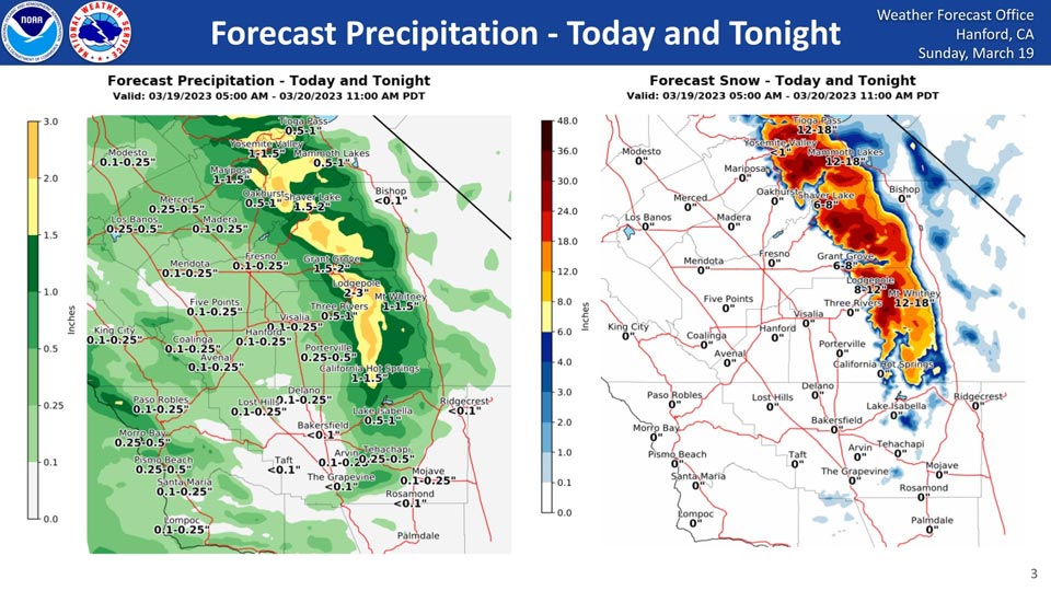
Projected Rainfall for Mariposa 1.00" to 1.50"
Projected Rainfall for Oakhurst 1.00" to 1.50" Now 0.50" to 1.00"
Projected Snowfall for Mariposa: 0"
Projected Snowfall for Oakhurst: 0"
Projected Rainfall for Yosemite Valley: 1.50" to 2.00" Now 1.00" to 1.50"
Projected Snowfall for Yosemite Valley: Less than an inch.
March 19, 2023 - The National Weather Service Hanford Office reports the latest precipitation totals for Sunday through Monday morning.
The San Joaquin Valley could see up to an inch of rain while high Sierra elevations could see 1-3 inches of rain, and the Sierra could see 6-12 inches of snow in some places.
Snow levels will start at 5,500 feet on Sunday, peak at 6,800 feet late Sunday night, and end at 4500 feet on Monday morning.
Area Forecast Discussion
National Weather Service Hanford CA143 AM PDT Sun Mar 19 2023
.SYNOPSIS...
A small storm comes through this morning through tomorrow. A bigger
storm with moisture influence from another atmospheric river
starts Monday night through Wednesday. A dry break is expected
from THursday through Friday morning. A third storm is expected
for Friday afternoon through Saturday.
&&
.DISCUSSION...
GEFS and European model ensembles are in very good agreement for
the next several days with the series of troughs moving through.
The first trough is currently sliding in with a westerly flow
aloft. This first trough is bringing some rain to the San Joaquin
Valley and snow in the Sierra Nevada. A Winter Storm Warning will
take effect at 5 AM this morning and will go until 11 AM Monday as
1 to 3 feet of snow is expected in the Sierra Nevada.
Probability wise for the first storm, Fresno and points north have a
45 to 55 percent chance of at least quarter of an inch of rain. The
probability goes down for Kings and Tulare County where the
probability of at least quarter of an inch of rain falls to 20 to 40
percent chance. Kern County has less than 20 percent chance of a
quarter of inch of rain in this first storm.
The second storm slides in late Monday night into Tuesday morning.
This storm will bring more rain to the San Joaquin Valley Tuesday
through Wednesday morning as it will pump in moisture from an
atmospheric river. The Sierra Nevada is looking at 2 to 4 of
snow for the Southern portions and 1 to 4 feet in the Yosemite and
Central portion. This atmospheric river will not be as strong
as some of the previous atmospheric river events as the Integrated
Water Vapor values for this storm are forecast to be around 1.00
inches which is much lower than the recent atmospheric river
events. Currently, a Winter Storm Watch is in effect for this
second storm but it will likely be upgraded to a Warning.
A small ridge moves in Thursday which will provide a break in the
rain and snow. However, another trough is expected to move in Friday
through Saturday. Both GEFS and European model ensembles are
showing that the trough next weekend sliding down the Great Basin
as an inside slider, which will be monitored for possible Mono
Winds.
&&
.AVIATION...Expect areas of MVFR with local IFR and mountain
obscurations as precipitation moves into the region after 10Z
Saturday. Otherwise, VFR conditions will prevail across the
central CA interior during the next 24 hours.
&&
.AIR QUALITY ISSUES...
ISSUED: 03/18/2023 12:54
EXPIRES: 03/19/2023 23:59
None.
&&
.CERTAINTY...
The level of certainty for days 1 and 2 is medium.
The level of certainty for days 3 through 7 is medium.
Certainty levels include low...medium...and high. Please visit
www.weather.gov/hnx/certainty.html for additional information
and/or to provide feedback.
&&
.HNX WATCHES/WARNINGS/ADVISORIES...
Winter Storm Watch from late Monday night through Wednesday
afternoon for CAZ318-320-322>331.
Winter Storm Warning from 5 AM early this morning to 11 AM PDT
Monday for CAZ323-325>331.
Source: NWS

