


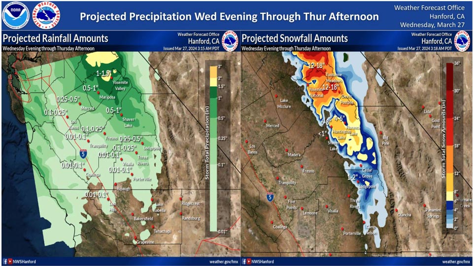
Projected rainfall for Mariposa: 0.50" to 1.00"
Projected rainfall for Yosemite Valley: 1.00" to 1.50"
March 27, 2024 - National Weather Service Hanford Office officials report the latest forecast rainfall and snowfall amounts for Wednesday evening through Thursday afternoon.Area Forecast Discussion
National Weather Service Hanford CA
235 AM PDT Wed Mar 27 2024
.UPDATE...Corrected Aviation Section.
&&
.KEY MESSAGES...
1. A warming trend continues today.
2. A weak storm system will be responsible for periods of
mainly light precipitation north of Kern County this evening
through Thursday.
3. There is around 55 to 65 percent chance of one foot of snow
or more in the Sierra Nevada above 6,000 feet Friday afternoon
through Sunday.
4. There is around 55 to 65 percent chance of one inch of rain
or more in the Sierra Nevada foothills and about 25 to 50
percent for the Kern County mountains Friday afternoon through
Sunday.
5. Dry, warmer conditions are on tap for the first part of next
week.
&&
.DISCUSSION...
Today's highs are on track to warm by a few degrees; high
temperatures mainly in the lower 70's are on tap for the warmest
locations, including the San Joaquin Valley and Kern County
desert. This is due to weak ridging passing over the Golden
State. However, the next low pressure system arrives late
tomorrow night and will bring low to moderate impacts due to
precipitation and increased winds into Thursday. At this time,
it appears the northern portions of the Mojave Desert Slopes in
eastern Kern County (such as Walker Pass where the probability
is as high as 70 percent, per the latest HREF, but diminishes
dramatically to the south) could report gusts of 45 mph or
stronger from Thursday morning until the following evening. So,
due to the relatively localized area depicted in the latest
HREF, will hold off on wind highlights for the time being. While
the system weakens as it travels southward, it will provide
enough moisture and lift for rain and mountain snow from late
this evening until Thursday afternoon.
The next low pressure system arrives Friday, and the potential
for impactful weather is greater with this system. In addition,
cool, unsettled weather continues until at least the afternoon
of Easter Sunday. Forecast guidance agrees that the low
pressure system will track along the coast as it moves southward
before it moves inland over Southern CA. This particular trajectory
tends to favor more precipitation over the higher terrain
(coastal ranges, the Sierra Nevada, and Kern County mountains),
rather than in the Central Valley. Probabilistic data currently
indicate around a 55 to 65 percent chance that the Sierra
foothills will receive an inch of rain while the Sierra Nevada
receives at least a foot of snow during Friday through the
upcoming weekend. In addition, probabilities are increasing for
an inch of precipitation for the Kern County mountains (25 to 50
percent, with the greatest chances towards the Tehachapi
Mountains and the Frazier Park areas). The bulk of the
precipitation occurs Friday night into Saturday afternoon;
mainly light showers are projected afterward. By Saturday
evening the pattern shifts to wrap-around moisture associated
with the upper-level low. Easter Sunday will remain cool with
light showers until the late afternoon/early evening, at least
over the Sierra Nevada into the Kern County mountains and far
southern SJ Valley. By Monday, the upper-level low treks
eastward into the Desert Southwest, though forecast highs are a
touch below seasonal averages.
Beyond Monday, it is reasonable that a building ridge of high
pressure returns for at least the first part of next week along
with above average temperatures. Probabilistic data show a high
temperature of at least 80 degrees by next Wednesday at 15 to
35 percent in the Central Valley and about 60 to 75 percent
chance of highs at least 75 degrees.
&&
.AVIATION...
Areas of MVFR with local IFR for areas mainly Fresno County
northward due to incoming precipitation beginning 00Z Thu and
spreading south to Tulare and Kings Counties by 06Z Thu. Otherwise,
VFR conditions will prevail across Central California for at least
the next 24 hours.
&&
.AIR QUALITY ISSUES...
None.
&&
.CERTAINTY...
The level of certainty for days 1 and 2 is medium.
The level of certainty for days 3 through 7 is medium.
Certainty levels include low...medium...and high. Please visit
www.weather.gov/hnx/certainty.html for additional information
and/or to provide feedback.
&&
.HNX WATCHES/WARNINGS/ADVISORIES...
Winter Weather Advisory above 7000 feet from 8 PM this evening
to 5 PM PDT Thursday for CAZ323-326.
Source: NWS

