


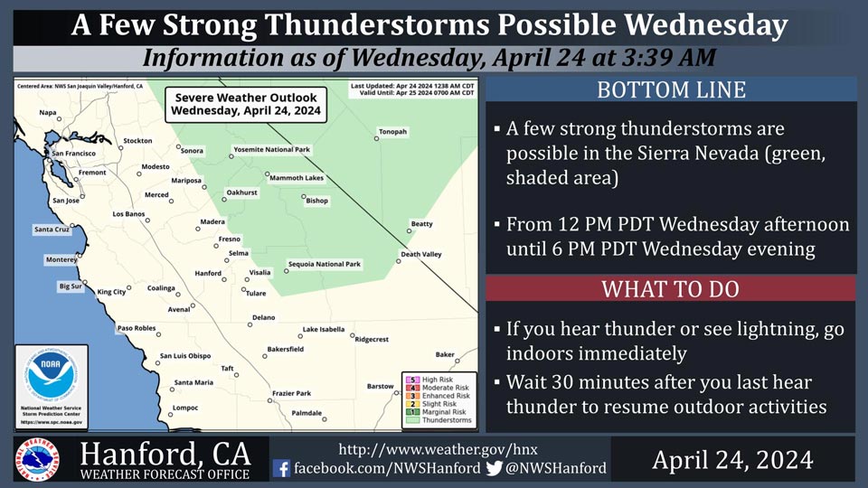
Possible Thunderstorms in portions of Mariposa, Madera, Fresno and Tuolumne Counties and Yosemite National Park
April 24, 2024 - National Weather Service Hanford Office officials report a few strong thunderstorms are possible in the Sierra Nevada from 12:00 P.M. Wednesday afternoon until 6:00 P.M. Wednesday evening.
Small hail and wind gusts near 45 miles per hour are a couple of hazards associated with strong thunderstorms.
In addition to dangerous cloud to ground lightning strikes, any thunderstorm can produce intense rainfall rates, leading to localized flooding.
Area Forecast Discussion
National Weather Service Hanford CA
352 AM PDT Wed Apr 24 2024
.KEY MESSAGES...
1. A cooling trend back to just below seasonal
normals lasting through Friday.
2. A few thunderstorms are possible in the Sierra Nevada this
afternoon.
3. The next storm system will impact Central California Friday
with mountain snow, foothills rain, and a chance of valley
thunderstorms.
4. A Wind Advisory has been issued for the Kern County
Mountains and Mojave Desert Slopes valid from 5pm Wednesday
through 11pm Friday.
&&
.DISCUSSION...
An upper level low pressure trough is currently located over
the eastern Pacific Ocean and will gradually move onshore into
the western United States this evening. This approaching system
is breaking down an upper level ridging pattern that had been
set up over central California since Saturday. Cooler
temperatures are expected over the region as a result of the
trough with afternoon highs around two to five degrees below
seasonal averages today through Saturday. Cyclonic flow around
the aforementioned system will result in stronger wind gusts in
the Southern Sierra Nevada, Kern County Mountains, and Mojave
Desert Slopes. A Wind Advisory has been issued for these areas
from 5 PM PDT this evening until 11 PM PDT Friday due to
expected sustained winds 25 to 35 miles per hour with gusts near
55 miles per hour possible. In addition to these conditions, a
few thunderstorms are possible along the crest of the Sierra
Nevada this afternoon as a result of orographic lifting. The
following are probabilities of thunderstorms for select
locations.
Tioga Pass 24%
Tuolumne Meadows 22%
Lake Thomas Edison 21%
Yosemite Valley 18%
Wawona 16%
Grant Grove 14%
Oakhurst 13%
Shaver Lake 13%
As this upper level trough progresses eastward out of the
region on Thursday, a weaker upper level system will take its
place into the weekend. The center of this trough is projected
to move through the Pacific Northwest region, with central
California located upstream of the axis. Northwesterly flow
aloft will take hold, resulting in the coolest conditions of the
week. The entire San Joaquin Valley has less than a 25 percent
chance of reaching 75 degrees; Ridgrecrest has the greatest
probability in the Kern County Desert at 35 percent.
Thunderstorms are possible again Friday afternoon in the Sierra
Nevada, but with additional chances spreading into the foothills
and eastern San Joaquin Valley. The following are probabilities
of thunderstorms for select locations.
Yosemite Valley 20%
Tioga Pass 19%
Oakhurst 18%
Shaver Lake 17%
Mariposa 17%
Three Rivers 14%
Fresno 10%
Merced 10%
In addition to the aforementioned conditions associated with
these systems, snowfall also is projected in the higher
elevations of the Sierra Nevada. Snow levels will be around
7,000 feet though with lesser amounts of moisture, snow
accumulation is expected to be relatively low near 2 to 3
inches. Ensemble guidance from the NBM expresses a 10 to 40
percent probability of two inches or greater for most of the
mountain areas above 7,000 feet, with a 50% chance of these
totals occurring at the highest elevations around Yosemite
National Park.
A zonal pattern will set up early next week with the exit of the
second upper level trough, bringing clearer, dry conditions to
central California through midweek. Maximum temperatures in the
San Joaquin Valley are expected to return to seasonal averages
in the low 80s, with highs in the mid 80s for the Kern County
Desert.
&&
.AVIATION...
Localized Sierra Crest MVFR conditions with afternoon
thunderstorms between 18Z and 03Z. Otherwise, VFR conditions
will prevail throughout Central California for at least the next
24 hours.
&&
.AIR QUALITY ISSUES...
ISSUED: 04/23/2024 14:45
EXPIRES: 04/24/2024 23:59
None.
&&
.CERTAINTY...
The level of certainty for days 1 and 2 is high.
The level of certainty for days 3 through 7 is medium.
Certainty levels include low...medium...and high. Please visit
www.weather.gov/hnx/certainty.html for additional information
and/or to provide feedback.
&&
.HNX WATCHES/WARNINGS/ADVISORIES...
Wind Advisory from 5 PM this afternoon to 11 PM PDT Friday for
CAZ331-333-334-337>339.
&&
Source: NWS

