


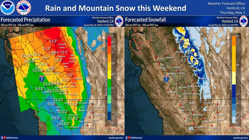
Projected rainfall for Mariposa: 1.00" to 1.50"
Projected rainfall for Yosemite Valley: 1.50" to 2.00"
May 2, 2024 - National Weather Service Hanford Office officials report the forecasted precipitation totals and snowfall totals between Saturday morning and Sunday morning.
Area Forecast Discussion
National Weather Service Hanford CA
213 AM PDT Thu May 2 2024
.KEY MESSAGES...
1. Warming conditions are will take place today and Friday with
highs rising to 3 to 7 degrees above normal on Friday.
2. A weekend storm system will likely bring snowfall to the
Sierra Nevada and rainfall to the San Joaquin Valley and Sierra
foothills as well as breezy to windy conditions across the
mountains and deserts.
3. High temperatures are forecast to cool to around 10 to 15
degrees below normal by Sunday.
4. Dry weather and a warming trend will take place Monday
through Wednesday.
&&
.DISCUSSION...The upper ridge that has been situated off the CA
coast for the past few days is progged to shift inland today
and Friday resulting in a warming trend across our area with
slightly above normal readings today and even warmer readings
on Friday. Latest NBM probabilistic guidance is indicating
between a 30 and 50 percent PoE of 85 DEG F in the San Joaquin
Valley from Fresno southward on Friday.
Meanwhile, a large upper low pressure system is progged to drop
southeast out of the Gulf of AK on Friday and move into the PAC
NW and Norcal by Saturday. This will result in much cooler
temperatures and breezy to windy conditions prevailing across
the mountains and deserts over the weekend. It will also bring
possible precipitation to the area on Saturday and Saturday
night. Snow levels are progged to be above 8000 feet at the
onset of precipitation on Satruday and will lower to 6000 to
7000 feet by Saturday evening and to 5000 to 6000 feet by the
time the precipitation tapers off by Sunday morning. QPF is
trending higher with the weekend system with a quarter to three
quarters of an inch of rainfall now progged for the SR 99
corridor and eastward north of Kern County in the San Joaquin
Valley. Much of the Sierra foothills is progged to pick up
between half an inch to an inch of rainfall while 1 to 2 inches
of liquid precipitation is progged for the higher Sierra Nevada
Satruday and Saturday night. There will also be enough
instability for isolated thunderstorms from Kings Canyon
northward in the Sierra Nevada and adjacent foothills Satruday
afternoon and evening.
Sunday is expected to be an unseasonably cool day for our area
as the large upper low moves to the east of our area and a
modified polar airmass moves into our area behind it. High
temperatures on Sunday will be 10 to 15 DEG F below normal on
Sunday with NBM probabilistic guidance indicating a 50 to 75
percent chance of high temperatures below 70 DEG F across most
of the San Joaquin Valley.
Medium range progs are showing good ensemble agreement and are
indicating a slow wamring trend taking place across our area
between Monday and Wednesday with temperatures recovering to
near climatological normals by Wednesday and dry weather
prevailing across our area Monday through Wednesday.
&&
.AVIATION...VFR conditions will prevail across the central CA
interior for at least the next 24 hours.
&&
.AIR QUALITY ISSUES...None.
&&
.CERTAINTY...
The level of certainty for days 1 and 2 is high.
The level of certainty for days 3 through 7 is medium.
Certainty levels include low...medium...and high. Please visit
www.weather.gov/hnx/certainty.html for additional information
and/or to provide feedback.
&&
.HNX WATCHES/WARNINGS/ADVISORIES...None.
Source: NWS

