


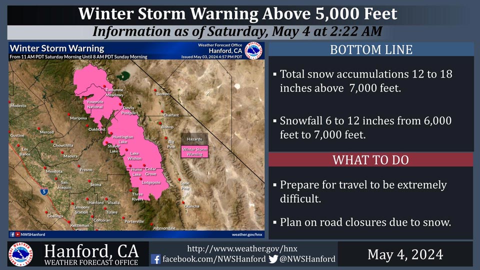
May 4, 2024 - National Weather Service Hanford Office officials report a Winter Storm Warning remains is in effect for the Sierra Nevada above 5,000 feet from 1.00 P.M. this afternoon until 8:00 A.M. Sunday morning.
The majority of this snow will fall this afternoon and this evening.
Wind will gust as high as 75 mph on exposed ridgetops and near the crest.
Motorists should be prepared for slick road conditions and potential travel delays.
Area Forecast Discussion
National Weather Service Hanford CA
1233 AM PDT Sat May 4 2024
.KEY MESSAGES...
1. Moderate to major winter storm impacts are expected in the
Sierra Nevada above 6,000 feet this afternoon and tonight due to
blowing snow and snow amounts up to 18 inches.
2. Damaging wind gusts are anticipated in the Mojave Desert
Slopes this afternoon through Sunday evening.
3. A few strong thunderstorms are possible in the Sierra Nevada
below 6,000 feet and adjacent foothills this afternoon.
4. A warming trend is expected Monday through at least Friday.
&&
.DISCUSSION...
An upper-level area of low pressure just off the coast of the
Pacific Northwest will move southeastward today. Precipitation
ahead of this storm system will overspread Central California
from north to south this afternoon. The cyclone aloft will move
eastward across Northern California tonight, before entering the
Great Basin Sunday. Moderate to major winter storm impacts are
anticipated in the Sierra Nevada above 6,000 feet this afternoon
and tonight due to blowing snow and snow amounts up to 18
inches. A Winter Storm Warning is in effect. Damaging wind gusts
are expected in the Mojave Desert Slopes this afternoon through
Sunday evening. There is a 64 percent chance of wind gusts of
58 mph or higher at Walker Pass tonight. A High Wind Warning is
in effect. Strong, gusty west winds are anticipated in the
remainder of the Mojave Desert this afternoon through Sunday
evening. A Wind Advisory is in effect. A few strong
thunderstorms are conceivable in the Sierra Nevada below 6,000
feet and adjacent foothills this afternoon. Here are
thunderstorm probabilities for select locations in the Sierra
Nevada below 6,000 feet and adjacent foothills this afternoon:
Shaver Lake - 22%
Auberry - 21%
Oakhurst - 20%
Coarsegold - 20%
Mariposa - 18%
Yosemite Valley - 17%
The forecast area will remain between a pesky atmospheric
disturbance over the Central United States and a ridge of high
pressure over the Eastern Pacific Ocean next week. As far as
temperatures are concerned, high temperatures this afternoon
will be eleven to thirteen degrees cooler than yesterday
afternoon. Maximum temperatures Sunday afternoon will be around
fifteen degrees below normal for this time of year. A warming
trend is anticipated Monday through at least Friday. By Friday
afternoon, high temperatures will be seven to nine degrees above
their typical values for the first half of May.
&&
.AVIATION...
VFR conditions will prevail across Central California this
morning. MVFR or lower conditions are likely in and near
precipitation this afternoon and this evening. Mountain
obscurations are expected in the Sierra Nevada and Kern County
mountains tonight.
&&
.AIR QUALITY ISSUES...
None.
&&
.CERTAINTY...
The level of certainty for days 1 and 2 is medium.
The level of certainty for days 3 through 7 is medium.
Certainty levels include low, medium, and high. Please visit
www.weather.gov/hnx/certainty.html for additional information
and/or to provide feedback.
&&
.HNX WATCHES/WARNINGS/ADVISORIES...
High Wind Warning from 2 PM this afternoon to 11 PM PDT Sunday
for CAZ338.
Wind Advisory from 2 PM this afternoon to 11 PM PDT Sunday for
CAZ337-339.
Winter Storm Warning above 6000 feet from 1 PM this afternoon
to 8 AM PDT Sunday for CAZ323-326>330.
Source: NWS

