
June – September 2026 South Ops Highlights
• Precipitation will likely be below normal in June and then there will likely be near to above normal monsoonal shower and thunderstorm activity July through September.
• Temperatures will likely be above normal through September, except near normal coastal areas in June.
• The marine layer will likely be more shallow and not penetrate as far inland as normal through September
Weather Discussion
June 1, 2026 - High pressure off the California Coast brought above normal temperatures away from the coastal areas for much of May. However, a couple deep areas of low pressure brought well below normal temperatures May 3-5 and May 26-28. A daily 1,500 to 3,000 deep marine layer brought near normal temperatures to the coastal areas most days this month. For the month as a whole, most inland locations received temperatures that were 2 to 6 degrees above normal and most coastal areas received temperatures that were within 2 degrees on either side of normal (Fig 1).
The two deep areas of low pressure brought scattered showers and isolated thunderstorms to the region. Otherwise, there was little or no rainfall across the region in May. Most Central and Southern California locations received well below normal rainfall for May (Fig 2).
Westerly winds of 20 to 30 mph with gusts to 50 mph surfaced across the mountain ridges and desert passes with the Pacific troughs. Otherwise, there were westerly winds of 15 to 25 mph with gusts to 40 mph most afternoons across wind prone areas. A weak Santa Ana wind event caused a significant amount of fire activity across the region May 18-19 with several new large fires.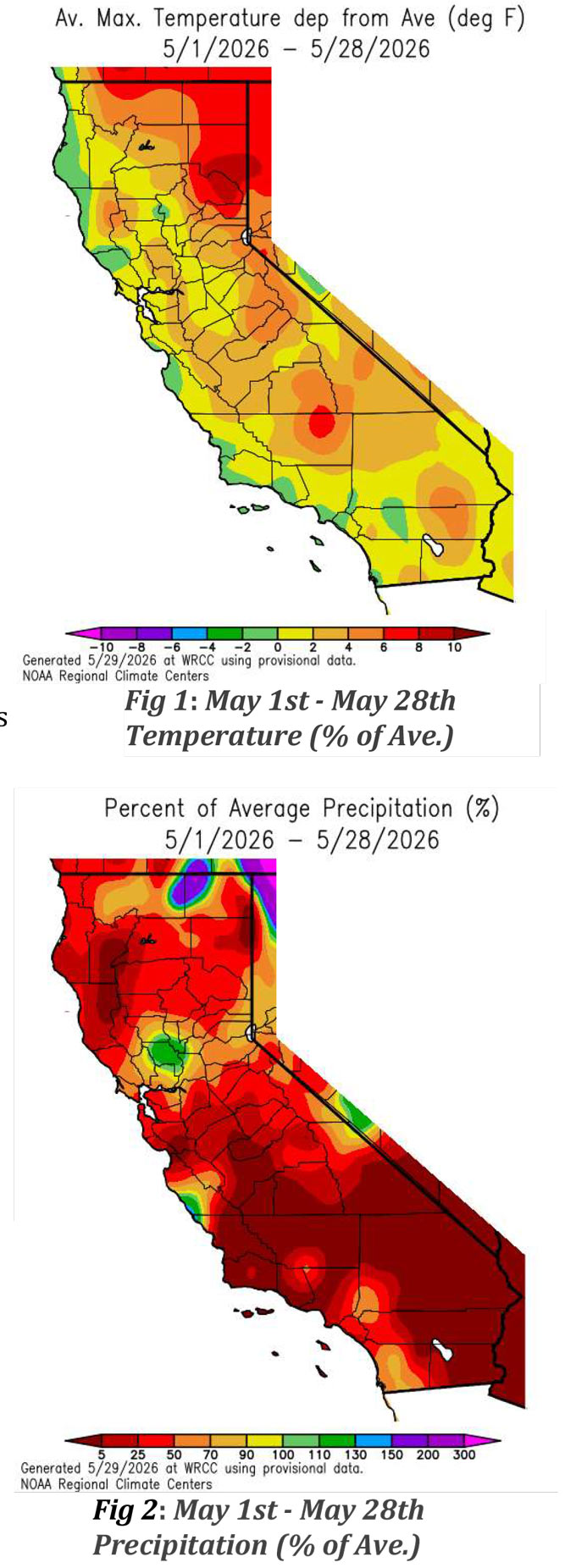
Fuels Discussion
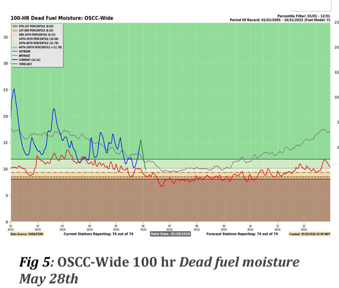
Moderate drought now exists over eastern San Bernardino County near the Colorado River. Abnormally dry conditions exist across most other Eastern and Northern desert areas as well as the Sierra. Otherwise, there is no drought across Central and Southern California (Fig 3). Warm and dry conditions away from the coastal areas caused both the 1,000-hr and the 100-hr dead fuel moisture to be below normal for much of May, but cool and humid conditions brought near to a little above normal values during the beginning and end of the month (Figs 4@5). There was a substantial decrease in the live fuel moisture this month and it is now mainly between 80% and 100% (Fig 6). The grasses are now fully cured across the lower elevations and some of the brush is now also starting to cure across the lower elevations.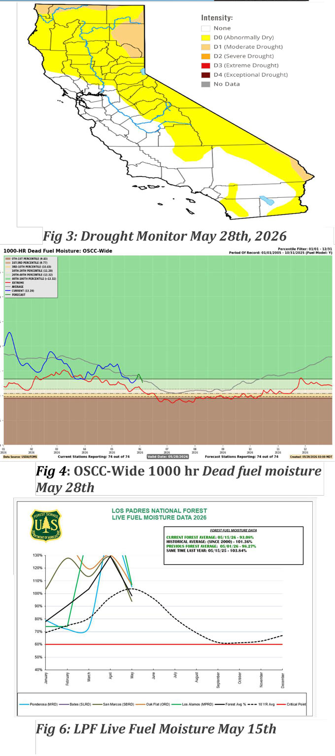
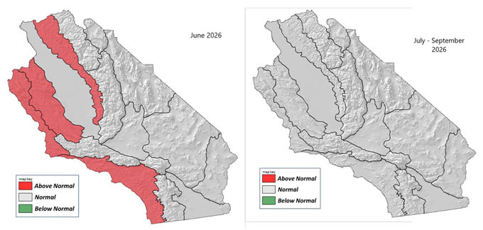
SOUTH OPS OUTLOOK
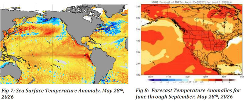
Sea surface temperatures off the West Coast remain above normal and are forecast to remain above normal through at least September (Figs 7@8). These above normal sea surface temperatures will likely cause air temperatures to be mainly above normal from June through September. However, the marine layer may allow for near normal temperatures across the coastal areas in June. Also, the above normal sea surface temperatures off the West Coast will likely cause a lower amount of weak low-pressure areas to form off the coast in June and thus the continuation of below normal rainfall.
Above normal sea surface temperatures over the Gulf of Mexico will likely bring near to above normal monsoonal shower and thunderstorm activity mid-July through September. There will also be an above normal chance of remnants from hurricanes over the Tropical Pacific making it up into the region due to well above normal sea surface temperatures over the sub-tropical Pacific Ocean. There will likely be a significant rainfall across Southern California before the first Santa Ana wind event this fall. Above normal temperatures and dry conditions will likely cause the potential for large fire to be above normal across the lower elevations in June. Otherwise, expect the potential for large fire to be near normal through September.
Source: Predictive Services