


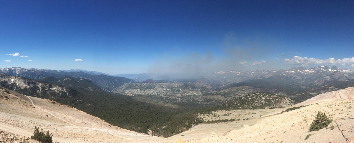
 Smoke from the Lions Fire seen from the top of Mammoth Mountain on Sunday, July 1, 2018
Credit: Sierra National Forest - Inciweb
Sunday Update Picture & Info. (below): 8:35 P.M.
July 1, 2018 - Today is the fourth day of burn-out operations on the Lions Fire, reducing fuels within the containment lines already constructed by firefighters. These operations are consuming fuels that might otherwise smolder and carry fire for much longer, thus reducing the overall duration of operations and smoke impacts to the community. Aerial ignitions were employed yesterday, and will be employed again today, to ensure safer and more efficient burn-out operations. The fire is 3,400 acres, and 15% contained.
Wind patterns are bringing more smoke into Mammoth Lakes and other locations east of the fire. Significant smoke impacts are expected over the next 48 hours, reducing thereafter as the burn down period progresses. Residents are advised to keep windows closed and limit their outdoor activity during periods of heavy smoke.
This lightning-caused fire was detected in early June and is located in the Ansel Adams Wilderness. It is located primarily in the Stairway Creek drainage, north and west of the Middle Fork of the San Joaquin River.
To provide for public and firefighter safety, the following National Forest System Trails near the burned area have been temporarily closed: Sierra National Forest Trails No. 26E01 (Mammoth Trail) to the Inyo NF Boundary, 26E14, 26E56, and 26E46 from the Inyo NF boundary. Inyo NF trail closures include 26E01 from the Sierra NF to 2601 junction, and 2601 from the boundary of the Inyo NF and Devils Postpile National Monument (King Creek Trail).
Shuttles to Devils Postpile National Monument and Reds Meadow Valley are running, and trails there are open. The Pacific Crest Trail and the John Muir Trail are open. Visitors should expect smoke impacts of variable intensity.
The Lions Fire is providing critical fuel reduction, particularly in the area affected by a massive tree blow-down event in 2011, which left as many as 100 large downed trees per acre in a wilderness area with very limited access. This fire reduces the risk of larger, more severe fires in the future.
Air quality forecasts are available at https://airnow.gov/index.cfm?action=topics.smoke_wildfires
For more information about smoke conditions in the area, visit webcams at www.mammothmountain.com and the alert tab at nps.gov/DEPO
For more information, call (760) 582-5203.
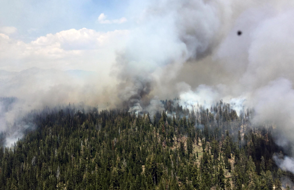 Burn operations are made safer and more efficient by using aerial (helicopter) ignitions in areas with poor access on the ground. Unstable atmospheric conditions allowed for good smoke dispersion late into the afternoon. Credit: Sierra National Forest - Inciweb
Sunday Update Picture & Info.: 8:35 P.M.
Basic Information
|
Current as of |
7/1/2018, 7:35:45 PM |
|
Incident Type |
Wildfire |
|
Cause |
Lightning Strike |
|
Date of Origin |
Monday June 11th, 2018 approx. 12:00 PM |
|
Location |
7 miles southwest of Mammoth Lakes |
|
Incident Commander |
Stephen Fillmore, Type 3 IC |
|
Incident Description |
The Fire Is Burning At Approximately 6000- 8000' In Red Fir (compact) Needle Cast And Brush As Well As Heavy Blowdown From 2011 Wind Event. |
|
Coordinates |
37.571 latitude, -119.118 longitude |
Current Situation
|
Total Personnel |
349 |
|
Size |
3,400 Acres |
|
Percent of Perimeter Contained |
15% |
|
Estimated Containment Date |
Saturday July 14th, 2018 approx. 12:00 AM |
|
Fuels Involved |
Timber (Litter and understory) Brush (2 feet) |
|
Significant Events |
Aerial ignitions Moderate Flanking Single tree torching |
Outlook
|
Planned Actions |
Crews will continue to improve and burn out control lines utilizing natural barriers to the extent possible. Helicopter water drops will check fire in inaccessible terrain. |
|
Projected Incident Activity |
Continued spread to West and North especially in thermal belts with poor recoveries and in dry fuels. |
|
Remarks |
2,050 acres on the Sierra National Forest; 1,350 acres on the Inyo National Forest. |
Current Weather
|
Weather Concerns |
Chance of thunderstorms Sunday and Monday. Gusty west winds predicted throughout the week. |
Sunday Update: 8:10 A.M.
Basic Information
|
Current as of |
7/1/2018, 8:09:59 AM |
|
Incident Type |
Wildfire |
|
Cause |
Lightning Strike |
|
Date of Origin |
Monday June 11th, 2018 approx. 12:00 PM |
|
Location |
7 miles southwest of Mammoth Lakes |
|
Incident Commander |
Stephen Fillmore, Type 3 IC |
|
Incident Description |
The Fire Is Burning At Approximately 6000- 8000' In Red Fir (compact) Needle Cast And Brush As Well As Heavy Blowdown From 2011 Wind Event. |
|
Coordinates |
37.571 latitude, -119.118 longitude |
Current Situation
|
Total Personnel |
349 |
|
Size |
3,400 Acres |
|
Percent of Perimeter Contained |
15% |
|
Estimated Containment Date |
Saturday July 14th, 2018 approx. 12:00 AM |
|
Fuels Involved |
Timber (Litter and understory) Brush (2 feet) |
|
Significant Events |
Aerial ignitions Moderate Flanking Single tree torching |
Outlook
|
Planned Actions |
Crews will continue to improve and burn out control lines utilizing natural barriers to the extent possible. Helicopter water drops will check fire in inaccessible terrain. |
|
Projected Incident Activity |
Continued spread to West and North especially in thermal belts with poor recoveries and in dry fuels. |
|
Remarks |
2,050 acres on the Sierra National Forest; 1,350 acres on the Inyo National Forest. |
Current Weather
|
Weather Concerns |
Chance of thunderstorms Sunday and Monday. Gusty west winds predicted throughout the week. |
Air Quality Report 7-1-2018
Fire
The fire continues to burn in Red Fir forest interspersed with low lying brush. Fuels in the fire area are becoming increasingly available to burn as seasonal drying continues. Firefighters resume burn operations to consume fuel on the North end of the fire.
Smoke
Increased smoke impacts in the fire area for the next few days. Wind will push smoke East from the fire into Mammoth Lakes and the Owens Valley. After Sunday, condition will improve each morning around 1100 as day time heating moves smoke from the area. Monitor Smoke Outlook each day for more precise daily smoke forecasts and time frames.
Weather
An upper ridge will intensify through Monday bringing a return to above normal temperatures. North to northeast winds will prevail through 0900 Sunday then becoming light during most of the day Sunday. The flow then turns to the southwest late Sunday and beyond as the next trough develops along the Pacific Northwest coast.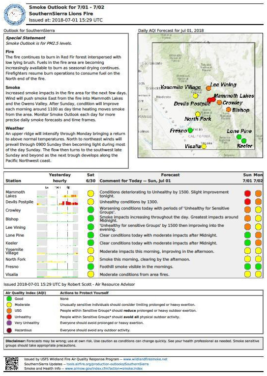
Inyo National Forest Temporary Trail Closures
Inyo National Forest trail closures include 26E01 from the Sierra National Forest border to the 2601 junction, and 2601 from the boundary of the Inyo National Forest and Devils Postpile National Monument (King Creek Trail). See fire map below, 'click' map for full size PDF.
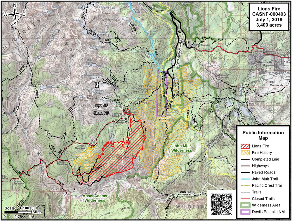 Source: Inciweb
Related information:
Sierra National Forest Lions Fire Monday Evening Updates
Sierra National Forest Lions Fire Update for Tuesday, June 26, 2018
Sierra National Forest Lions Fire Update for Wednesday, June 27, 2018
Sierra National Forest Lions Fire Update for Thursday, June 28, 2018
Sierra National Forest Lions Fire Update for Friday, June 29, 2018
Sierra National Forest Lions Fire Update for Saturday, June 30, 2018

