


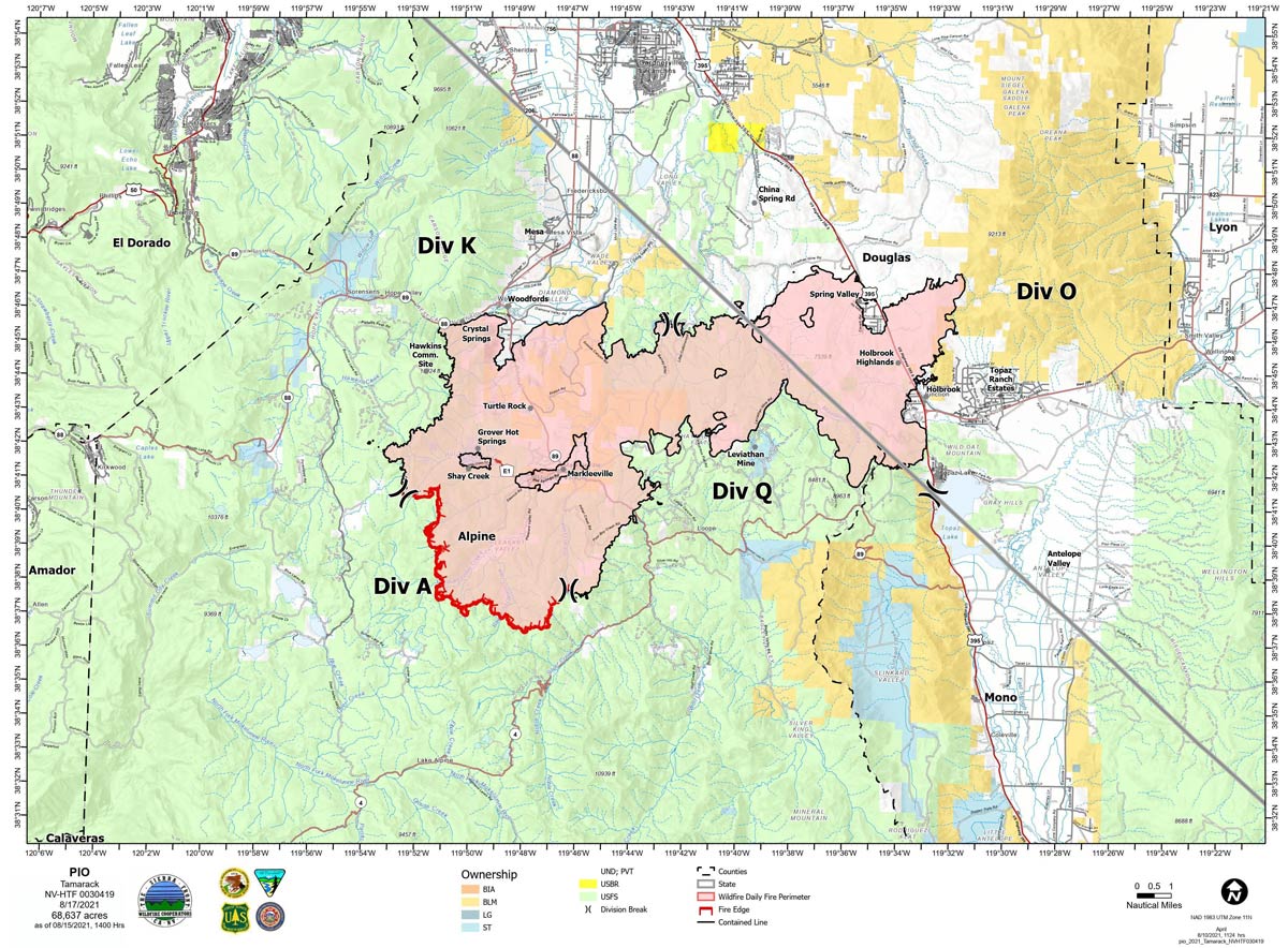
Map for Tuesday, August 17, 2021
Note: 1,200 Pixels Wide
NOTE: Maps represent approximate information.
Click here for: Tamarack Fire in Alpine County Updates for Sunday, August 22, 2021
Evening Update: Minimal fire behavior. Minimal risk of ember cast from Caldor Fire due to SW-W winds. Tamarack Fire as of Saturday evening is still at 68,637 Acres with 82% Containment.
Basic Information
| Current as of | 8/21/2021, 7:04:41 PM |
| Incident Type | Wildfire |
| Cause | Lightning |
| Date of Origin | Sunday July 04th, 2021 approx. 04:00 PM |
| Location | 16 Miles south of Gardnerville, NV |
| Incident Commander | Scott Stephenson, IC Tom Raw, Deputy IC |
| Incident Description | This Incident Continues To Be Managed With A Full Suppression Strategy, However Steep Inaccessible Terrain In Division Alpha Necessitates A Suppression Strategy Of Confinement. |
| Coordinates | 38.628 latitude, -119.857 longitude |
Current Situation
| Total Personnel | 225 |
| Size | 68,637 Acres |
| Percent of Perimeter Contained | 82% |
| Estimated Containment Date | Tuesday August 31st, 2021 approx. 12:00 AM |
| Fuels Involved |
Timber (Grass and Understory) Chaparral (6 feet) Timber (Litter and Understory) |
| Significant Events |
Minimal Creeping Smoldering |
Outlook
| Planned Actions |
Divs K & O - Keep fire south of China Spring and west of Highway 395. Keep fire south of Highway 88 and east of Blue Lake Road. Continue right sizing organization. Div K, O and Q in patrol status. Divs A- Keep fire north of Highway 89 (Monitor pass) and Hwy 4. Continue right sizing organization. Hazard tree mitigation in Markleeville and Pleasant Valley areas completed. Hazard mitigation on Hot Springs road and Indian Creek campground continues. |
| Projected Incident Activity |
12 hours: Minimal fire behavior. Minimal risk of ember cast from Caldor Fire due to SW-W winds. Widespread smoke and haze, sunny. Temperatures 47-49. Winds SW 20-25 mph. Haines 4. 24 hours: Minimal fire behavior. Widespread smoke and haze, sunny. Temperatures 66 to 81. Winds WSW 10-15 mph, gusts 25 mph. Haines 4. |
| Remarks |
Steep rugged terrain in Division Alpha necessitates a suppression strategy of confinement. Perimeter in Division Alpha represents 18% of the total fire perimeter. The remaining perimeter (82%) has been contained. |
Current Weather
| Weather Concerns |
Stronger WSW winds today due to a cold front moving through the region. The winds are expected to be lighter than those earlier in the week. General SW flow to remain over the region, with typical afternoon breezes Sunday and into the start of next week. It will remain quite dry with no chance of rain in the long-range forecast. Observed: Sunny in the morning turned to widespread smoke and haze for the rest of the day. Southwest winds 7-8 mph increased to 15-20 mph with gusts 30-40 mph. temperatures mid to high 70's. Relative humidity 23%. Haines3. Forecast: Tonight, widespread haze and smoke, partially clearing. Temperatures high 40's. Southwest winds 10-20 mph, gusts 25-40 mph. |
August 21, 2021 - Tamarack Fire Update for Saturday, August 21, 2021. Size: 68,637 acres with Containment: at 82%.
Sierra Front Type 3 Incident Management Team 1
Scott Stephenson, Incident Commander
Information Phone: 775-434-8629 (public and media)
Email: 2021.tamarack@firenet.gov
Information Staffing Hours: 8 a.m. to 8 p.m.
Current Situation: Today, the West suppression repair group will continue Hazard Tree Mitigation work in Thornburg Canyon and Indian Creek . Residents in the Markleeville area as well as along Hwy 89 will continue to see heavy truck traffic.
On Monday August 23, Sierra Front Incident Management Team 1 will be transferring command of the Tamarack Fire to a local Type 4 organization.
West Repair Group - Continue Hazard Tree Mitigation in the Thornburg Canyon and Indian Creek Reservoir areas.
Divisions K, O and Q – One engine will continue to patrol these divisions.
Division A - Two Wildland Fire Modules will continue to mop-up in the Mokelumne Wilderness area. The modules will continue to be supported by a helicopter for both water drops and supplies. The Wildland Fire Module will remain in the wilderness area for the foreseeable future.
Weather and Fuel Conditions: Sunny, with predicted high around 78 degrees, with relative humidity 23%. Southwest winds 7-8 mph becoming 15-20 mph with gusts to 30. Fuels remain extremely dry.
Closures, and Fire Restrictions: – Airport Road, leading to Indian Creek reservoir, is closed due to Hazard Tree Mitigation along the road. Humboldt-Toiyabe National Forest will temporarily close California portions of the Carson Ranger District effective August 22, 2021, at 11:59 pm., for safety reasons due to extreme fire conditions. For more information visit: https://www.fs.usda.gov/alerts/htnf/alerts-notices. https://www: .blm.gov/office/carson-city-district-office
Tamarack Fire Statistics: Size: 68,637 acres Containment: 82% Total Personnel: 229 Location: Markleeville, CA Reported: July 4, 2021 Cause: Lightning
Click here for: Tamarack Fire in Alpine County Updates for Friday, August 20, 2021
