


Note: Click here for Saturday's Dixie Fire Updates
Update: Dixie Fire East Zone Evening Operations Update Video for Friday, September 3, 2021
Update: Dixie Fire West Zone Virtual Community Meeting Evening Update Video for Friday, September 3, 2021
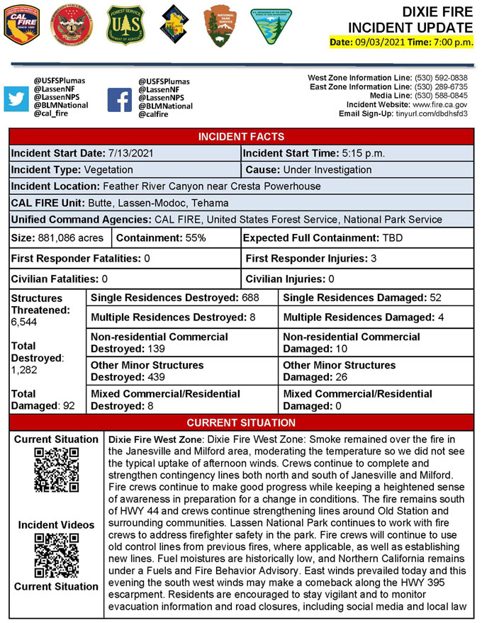
Evening Update Per CAL FIRE: California Dixie Fire is at 881,086 Acres, with 55% Containment, and 3,691 personnel assigned for Friday evening.
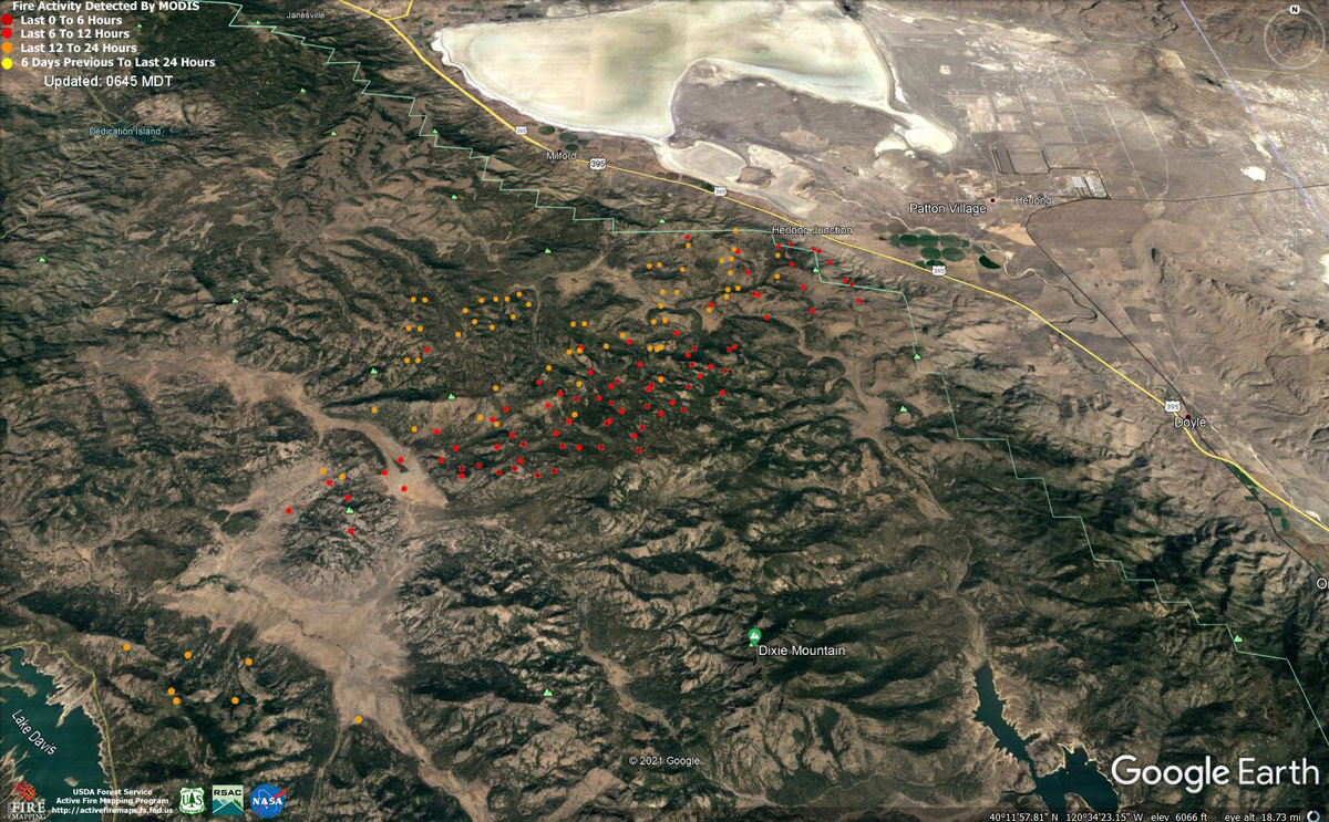
MODIS map of the Dixie Fire on Friday at 5:45 A.M PST
Note: 1,200 Pixels Wide - Note: Older Yellow not shown
MODIS Active Fire Mapping Program Frequently Asked Questions
News: Disaster Unemployment Assistance Has Been Approved for Those Impacted by Widespread California Fires
Update: Dixie Fire West Zone Operations Morning Briefing Video for Friday, September 3, 2021
Update: Dixie Fire East Zone Morning Operations Briefing Video for Friday, September 3, 2021
Update: Smoke/Air Quality Outlook for the Dixie Fire in the Eastern Sierra for Friday, September 3, 2021
September 3, 2021 - Dixie Fire is 868,781 acres and 55% contained for Friday morning.
868,781 Acres
55% Containment
3,860 Total Personnel
Lassen and Plumas National Forests — Resources are positioned to keep the fire from spreading east and north towards Dixie Valley and Milford as well as south towards Clover Valley and Portola. Crews will construct line directly on the fires edge and work in coordination with the West Zone to get around the finger-shaped blaze from Queen Creek to the escarpment and bring in air resources to keep fire from impacting Milford and HWY 395. Shifting winds will challenge crews throughout the day. Crews will continue to prepare and defend structures in Milford. The containment line from the west side of Lake Davis to Grizzly Ridge and north to Taylorsville will continue to be reinforced, mopped-up, and patrolled to protect the HWY 70 corridor. Ten handcrews of soldiers from Joint Base Lewis McChord will join the fire fight today, assisting firefighters in Genessee, Grizzly Ridge, and Clover Valley areas. Structure protection remains in place within Clover Valley, Dixie Valley, Genesee, Taylorsville, Greenhorn, and Cromberg.
Dixie Fire West Zone - The fire continued to burn actively through the night with terrain driven winds. The northern portion of the fire burned in the understory with isolated torching in the northern section west of HWY 44. The southern portion of the fire burned downslope towards HWY 395 until the winds subsided and started to change direction about midnight. Crews from the West Zone are assisting the East Zone to complete contingency lines both north and south of Janesville and Milford. Fire crews will continue to use old control lines from previous fires, where applicable, as well establishing new lines. Fuel moistures are historically low, and Northern California remains under Fuels and Fire Behavior Advisory. Today, light east to southeast winds are forecasted across the east of the fire area. Residents are encouraged to stay vigilant and to monitor evacuation information and road closures, including social media and local law enforcement websites for the most current information. Residents will see smoke coming from trees and stumps for days following their return. Proceed with caution because burned out areas may have unseen hazards. Residents are encouraged to call 911 if they are concerned about any active flames near their homes or businesses. Damage assessment remains ongoing. Change in threatened structures due to new Evacuation Warnings in Lassen, Plumas and Shasta County.
CAL FIRE
'Click' here to view full PDF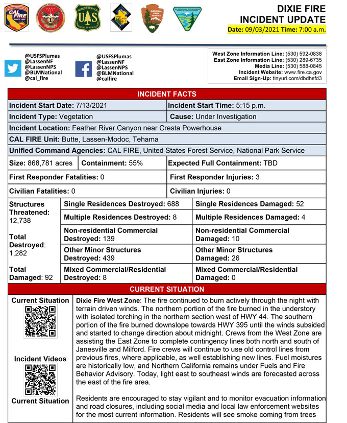
Click here for: California Dixie Fire Thursday, September 2, 2021 Updates
