


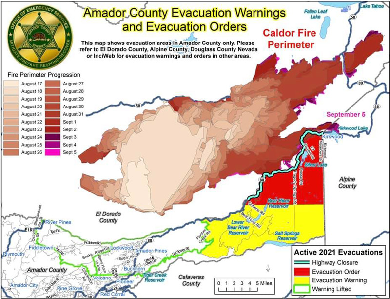
*** Evacuation Warning Area Lifted ***
The area described below is no longer under evacuation warning. The area is now clear of any restrictions and is outlined in green on the attached map.
(South of the El Dorado-Amador County line with a western border of Hwy 88 at Omo Ranch Road to Highway 88 at Tiger Creek Road. A southern border of Tiger Creek Road and Salt Springs Road, with an eastern border of Panther Creek Road/Ellis Road)
All other evacuation warning (YELLOW) and order (RED) areas east of Panther Creek Road are still in effect. If you have questions regarding our evacuation areas, please refer to the attached link to access our interactive mapping system at https://amador.maps.arcgis.com
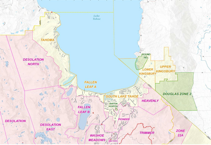
Evacuation Orders Downgraded - Effective Immediately for El Dorado County (3:00 P.M.)
Evacuation Order Update: The following Evacuation Orders have been downgraded to Evacuation Warnings in El Dorado County:
- South Lake Tahoe City Limits - From the Nevada State line west along Highway 50 to the Tahoe airport. Highway 89 from the city northwest to the city's edge at West Way. Also, Pioneer Trail from state line west to Al Tahoe Blvd.
- North of the City of South Lake Tahoe - All properties on the East (lake side) of Highway 89 extending north from the city limits to Emerald Bay. All properties on both sides of Highway 89 extending North from Emerald Bay through Tahoma.
The area of Fallen Leaf Lake, Christmas Valley, Meyers, and North Upper Truckee remains under an evacuation order.
Road Closures/Access
- Highway 88 is closed from Pickets Junction to Peddler Hill in Amador County • Highway 89 is closed from Highway 88 (Pickets Junction) to Highway 50 in Meyers
- US 50 is closed from Fresh Pond to Sawmill Road
- Road Closures in the basin are at the City Limits on Pioneer Trl, Lake Tahoe Blvd, and Hwy 50 at Sawmill
- 207/Kingsbury Grade and US 50 will be open.
- As with evacuating, please be patient and remain calm as you drive back to town with one access point available.
- Gas up before getting on the road.
REMINDER: There remains a temporary Emergency Closure in effect for the Eldorado National Forest through the end of September. This closure includes all National Forest Service lands, roads and trails within the Eldorado National Forest. See Forest Order 03-21-14 for more information. To request access to private lands within the warning area, accessible via closed Forest Service roads, please contact your local Forest Service District Office. The Lake Tahoe Basin Management Unit is closed under the Regional Emergency Closure of all National Forests in California. See the Regional Order for more information. Recreation residences and other permittees should contact their permit administrator for questions regarding access when their area becomes open for repopulation.
NOTES: The public is reminded to stay vigilant on current fire conditions. Please continue to adhere to road closures and any evacuation orders and warnings. A reminder to drive slowly and yield to emergency personnel in the area. There will be smoke in the respective areas as firefighters continue firefighting operations. If at any time you feel unsafe, please call 911. For tips on returning home after wildfire visit: Returning Home Checklist - Ready for Wildfire
Please go to: www.tinyurl.com/EDSOEVAC for an online evacuation map.
Food & Supplies Limited
Shop before you come home! Food and supplies are limited due to supply chains being cut off during the evacuation period. Refill prescriptions, gas up, and grab groceries and any personal items you might need before heading back to the city.
Transportation
If you need transportation services to get back home, Lake Tahoe Unified School District and Tahoe Transportation District (TTD) are providing bus service from the Reno Shelter located at 4590 South Virginia Street. Passengers will disembark at the Stateline Transit Center and connect with TTD buses operating on regular Routes 50 and 55.
Utilities
Please check with your local utilities company should you have questions regarding your services.
Wildlife
There are a lot more bears in town; bears not used to humans, so they’re not scared of cars and more likely to walk in front of you.
Message from US Coast Guard Sector San Francisco & US Department of Homeland Security
Mariners are urged to avoid all operations on the waters of Lake Tahoe until the impact of area wildfires have subsided.
For additional information regarding the Caldor Fire visit https://linktr.ee/imt6.
Evacuation Warnings Lifted – Effective Immediately for Amador County (2:45 P.M.)
Evacuation Order Update:
September 5, 2021 - The following Evacuation Warnings have been lifted in Amador County:
Zone 3 - The area described as South of the El Dorado - Amador County line with a western border of Highway 88 at Omo Ranch Road to Highway 88 at Tiger Creek Road. Southern  border of Tiger Creek Road and Salt Springs Road. Eastern border of Panther Creek Road.
REMINDER: There is still a temporary Emergency Closure in effect for the Eldorado National Forest through the end of September. This closure includes all National Forest Service lands, roads (including Mormon Emigrant Trail) and trails within the Eldorado National Forest. See Forest Order 03-21-14 for more information. To request access to private lands within the warning area, accessible via closed Forest Service roads, please contact your local Forest Service District Office. The Lake Tahoe Basin Management Unit is closed under the Regional Emergency Closure of all National Forests in California. See the Regional Order for more information.
Recreation residences and other permittees should contact their permit administrator for questions regarding access when their area becomes open for repopulation.
Notes: The public is reminded to stay vigilant on current fire conditions. Please continue to adhere to road closures and any evacuation orders and warnings. A reminder to drive slowly and yield to emergency personnel in the area. There will be smoke in the respective areas as firefighters continue firefighting operations. If at any time you feel unsafe, please call 911. For tips on returning home after wildfire visit: Returning Home Checklist - Ready for Wildfire Please go to: www.tinyurl.com/EDSOEVAC for an online evacuation map.
All previous evacuation orders and warnings remain in effect.
A mandatory evacuation order is defined as an immediate threat to life. This is a lawful order to leave now. The area is lawfully closed to public access.
An evacuation warning is defined as a potential threat to life and/or property. Those who require additional time to evacuate and those with pets and livestock should leave now.
For additional information regarding the Caldor Fire visit https://linktr.ee/imt6.
Source: CAL FIRE Amador-El Dorado Unit