


Update: Evacuation Orders Downgraded - Effective Immediately for El Dorado County (5:00 P.M.)
Evacuation Order Update:
The following Evacuation Orders have been downgraded to Evacuation Warnings in El Dorado County:
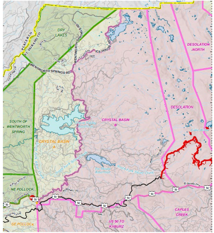
• West of Ice House Road, from the Placer County line, South to Highway 50 and East of Junction Reservoir.
The following Evacuation Warnings have been lifted in El Dorado County:
• South of Highway 50, North of Starkes Grade Road, East of Snows Road and West of Fresh Pond.
• North of Highway 50, South of Slab Creek Reservoir, East of Snows Road, West of Sly Park Road
• Southwest from the intersection of Wentworth Springs Road and Placer County line, through the Gerle Creek Divide Reservoir to Wentworth Springs Road, Northwest to the Placer County Line and East and South of the Placer County line.
• North of Slab Creek, South of Wentworth Springs Road, West of Junction Reservoir, and East of Sand Mountain.
• North of Highway 50 between Forebay Road and Ice House Road extending to the North to include Spring Valley Road.
• East of Highway E16, west of Steely Ridge Road, South of the North Fork of the Cosumnes River and North of the Middle Fork of the Cosumnes River.
• North of Omo Ranch Road, South of Grizzly Flat Road, East of Fairplay Road, West of Slug Gulch Road and Omo Ranch Road.
• The community of Omo Ranch South of the Middle fork of the Cosumnes River, North of Omo Ranch Road from Slug Gulch Road to 8N54.
• North of Omo Ranch Road East to North South Road, crossing both sides of Sopiago Creek.
NOTES: The fire has caused extensive damage to the Grizzly Flats Community Services District (CSD) water system. Grizzly Flats CSD is working diligently to make repairs. Customers should be prepared to bring potable water for all water needs. The Grizzly Flats CSD is working with the El Dorado County Office of Emergency Services and the American Red Cross to provide a limited amount of bottled water to those customers. Residual, standing water in pipelines is not safe for use and should be flushed out. For more information contact the Grizzly Flats CSD https://tinyurl.com/GrizzlyCaldor
REMINDER: There is still a temporary Emergency Closure in effect for the Eldorado National Forest through the end of September. This closure includes all National Forest Service lands, roads (including Mormon Emigrant Trail) and trails within the Eldorado National Forest. See Forest Order 03-21-14 for more information. To request access to private lands within the warning area, accessible via closed Forest Service roads, please contact your local Forest Service District Office. The Lake Tahoe Basin Management Unit is closed under the Regional Emergency Closure of all National Forests in California. See the Regional Order for more information. Recreation residences and other permittees should contact their permit administrator for questions regarding access when their area becomes open for repopulation. Repopulation consists of complex coordination between fire, law enforcement, public works, and utilities to ensure the safety of residents and fire responders alike.
The public is reminded to stay vigilant on current fire conditions. Please continue to adhere to road closures and any evacuation orders and warnings. A reminder to drive slowly and yield to emergency personnel in the area. There will be smoke in the respective areas as firefighters continue firefighting operations. If at any time you feel unsafe, please call 911. For tips on returning home after wildfire visit: Returning Home Checklist - Ready for Wildfire
For more specific information and resources from your local utility company visit the links below:
PG&E https://tinyurl.com/PGECaldor
Sacramento Municipal Utility District https://tinyurl.com/SMUDCaldor
El Dorado Irrigation District https://tinyurl.com/EIDCaldor
Grizzly Flats CSD: https://tinyurl.com/GrizzlyCaldor
Liberty Utilities: https://tinyurl.com/LibertyCaldor
ATT: https://tinyurl.com/ATTCaldor
Comcast: https://tinyurl.com/ComcastCald
See map below: Red area indicates Evacuation.
Yellow area indicates Evacuation Orders downgraded to Warning.
September 7, 2021 - EVACUATION ORDERS DOWNGRADED - EFFECTIVE IMMEDIATELY for El Dorado County
 EVACUATION ORDER UPDATE: The following Evacuation Orders have been downgraded to Evacuation Warnings in El Dorado County:
- All homes accessed from both sides of Pioneer Trail from the city limits starting at Al Tahoe Blvd and moving west stopping before Elks Club.
REMINDER: The Lake Tahoe Basin Management Unit is closed under the Regional Emergency Closure of all National Forests in California. See the Regional Order for more information. Recreation residences and other permittees should contact their permit administrator for questions regarding access when their area becomes open for repopulation. There is still a temporary Emergency Closure in effect for the Eldorado National Forest through the end of September. This closure includes all National Forest Service lands, roads (including Mormon Emigrant Trail) and trails within the Eldorado National Forest. See Forest Order 03-21-14 for more information. To request access to private lands within the warning area, accessible via closed Forest Service roads, please contact your local Forest Service District Office.
NOTES: The public is reminded to stay vigilant on current fire conditions. Please continue to adhere to road closures and any evacuation orders and warnings. A reminder to drive slowly and yield to emergency personnel in the area. There will be smoke in the respective areas as firefighters continue firefighting operations. If at any time you feel unsafe, please call 911. For tips on returning home after wildfire visit: Returning Home Checklist - Ready for Wildfire
Please go to: www.tinyurl.com/EDSOEVAC for an online evacuation map.
As you return to your residences, please be warned that you may not have working utilities. Carefully walk around your structures and check for damages, hot spots and hazardous materials. If you received a code red announcement to evacuate on your cell phone, you may not receive additional code red notices if your cell service is not reliable.
All previous evacuation orders and warnings remain in effect. A mandatory evacuation order is defined as an immediate threat to life. This is a lawful order to leave now. The area is lawfully closed to public access. An evacuation warning is defined as a potential threat to life and/or property. Those who require additional time to evacuate and those with pets and livestock should leave now.
For additional information regarding the Caldor Fire visit https://linktr.ee/imt6
Source: CAL FIRE Amador-El Dorado Unit
