


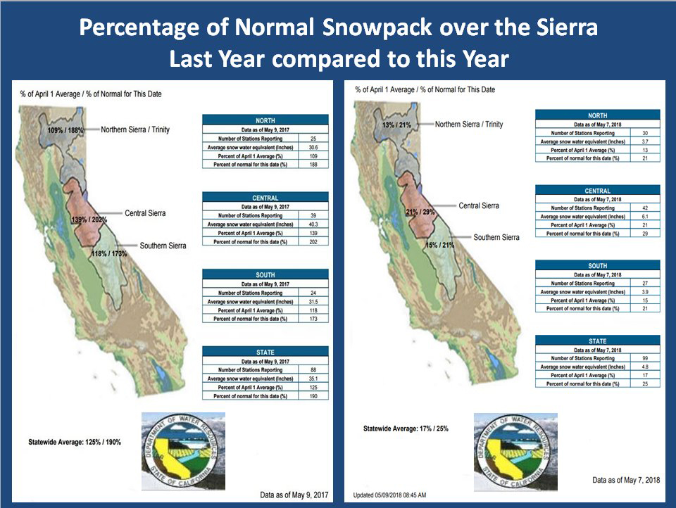
Source: DWR
May 16, 2018 - By Christine Souza - Access to precise, real-time data about the amount of water in the Sierra Nevada snowpack has become more critical than ever, California water managers say, in order to assist them in making informed decisions about an ever-less- predictable supply of water.
That's why water managers came to a panel discussion about advancements in snow-measurement technology during an Association of California Water Agencies conference in Sacramento last week. The discussion focused on the Airborne Snow Observatory, or ASO program, developed by researchers at the NASA Jet Propulsion Laboratory in Pasadena.
Turlock Irrigation District Chief Hydrologist Wes Monier said TID, which co-owns Don Pedro Reservoir on the Tuolumne River, has taken advantage of the program for the past six years. Calling the ASO program "the best solution going forward for the next generation," Monier said the technology helps with flood control, minimizes downstream impacts, provides more flexibility and optimizes the system.
"The state is working off a limited amount of water and from my perspective, that is decreasing," Monier said. "This program maximizes the existing water infrastructure. The ASO program will get the state water supply the latest technology. There is not one agency that would not benefit from this program."
The California Department of Water Resources has operated a manual snow survey since 1929, known as the California Cooperative Snow Surveys program, and monitors 130 snow sensors located in the Sierra and the Shasta-Trinity mountains. DWR State Climatologist Michael Anderson called improved observations key to enabling innovative water management.
"We want to try and make investments there to provide that information," Anderson said. "What used to work may not work in the future, and we're at the doorway of seeing some of that."
Noting that water reaches California in the form of atmospheric rivers, Anderson said, "We don't get it in nice, even increments—we get it in kicks, large punches. It is the character, size, number and timing of them that play a role in your seasonal, hydrologic outcome, including the size and distribution of the snowpack."
Thomas Painter, lead scientist at the NASA Jet Propulsion Laboratory, who developed the technology for measuring the snowpack, said the ASO uses an integrated imaging spectrometer and a dual laser system, installed in aircraft, to map snowpack topography and measure the snow-water equivalent and snow reflectivity in mountain basins.
"We touch every square meter of snowpack in these mountain basins, and then we model the snow density to get the snow water equivalent," Painter said. "We do monthly flights in the winter and we'll do biweekly flights in the spring during the snowmelt season. ASO provides a wall to wall, complete characterization regularly through the snowmelt season."
The Airborne Snow Observatory program began in California as a partnership from 2013 to 2016, and now DWR and other cooperators directly fund ASO snow survey operations. The program has expanded in recent years and to date has 240 surveys, conducted over snow around the western U.S.
"We still have tremendous uncertainties in the snowpack," Painter said. "Random variables can affect the reliability of the prediction; we're trying to harness those random variables and reduce their uncertainties."
Indirect benefits from the technology, he said, include forest imagery that can lead to improved forest and fuel management.
Kings River Watermaster Steve Haugen, who manages the Kings River Water Association, said quantifying and understanding the snowpack "is challenging our existing network and our existing methodologies." Though the association did not have ASO flights on the Kings River, Haugen said flights over the San Joaquin River assisted his decision-making.
"There's a problem with variability," he said. "Last year, our snow sensors were at zero and we still had inflow into the reservoir of 20,000 cubic feet per second. We were flying blind at that point."
Haugen said the ASO program "does an excellent job" of providing exact figures for snow water content in a watershed.
"As a reservoir manager, we've got to convert that into inflow," he said. "We have to know how much of that snowpack actually makes it into the reservoir and when it comes in."
Jeff Payne, director of water policy for the Friant Water Authority, said the authority signed up for a three-year program to kick-start ASO for the watershed, and said the results are beginning to show the value of the technology.
"Snow is a tremendously important resource for California and we have a nearly century-old program for monitoring it. ASO is going to provide a lot of benefits," Payne said.
For more information about the ASO program, see aso.jpl.nasa.gov/.
(Christine Souza is an assistant editor of Ag Alert. She may be contacted at csouza@cfbf.com.)
Reprinted with permission: California Farm Bureau Federation

