


Statistics
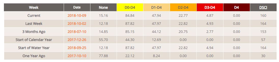
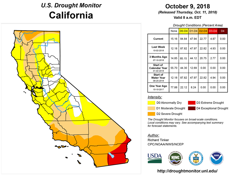
California and National Drought Summary for October 9, 2018
Northeast
October 11, 2018 - Light precipitation fell on most dry areas in the Northeast (Upstate New York eastward through Maine). Exceptions little or no precipitation in the north half of Maine, and slightly larger totals (1.5 to near 3.0 inches) dampened a few areas in Upstate New York and northern Vermont, as well as southeastern Maine.
The nondescript week led to little change in the Drought Monitor. A small patch of Downeast Maine improved from D1 to D0, otherwise conditions persisted from last week.
Southeast
Dry weather prevailed regionwide. Outside a swath in the North Carolina mountains, rainfall was isolated and totaled a few tenths of an inch at best. The dry (and unusually warm) week didn’t result in dramatic changes, but several areas were changed, all for the worse.
Just after the valid Drought Monitor period, Hurricane Michael, having formed and deepened rapidly in the Gulf of Mexico, approached category 5 strength on the on the Saffir-Simpson Scale just before it moved into the central Florida Panhandle, headed northeastward through most of the D0-D1 areas in the South Atlantic States, so the D0 expansion may not last long.
D1 expansion was limited to a small part of far northwestern Alabama. The extant D1 areas in eastern Georgia and southern South Carolina were unchanged. D0 expanded more broadly, particularly in west-central Alabama and over a swath from southwestern Georgia through the eastern Florida Panhandle.
South
Little precipitation fell on Tennessee, Arkansas, Mississippi, and Louisiana this week. As a result, most of the D0 and D1 patches were unchanged, but isolated areas (from one to a few counties in size) in northeastern Mississippi, south-central Tennessee, and northern Arkansas did deteriorate. In most cases, D0 expanded into the region.
Western Louisiana, the southeastern half of Texas, and eastern Oklahoma saw more precipitation than the states farther east, but only scattered small areas recorded over 1.5 inches of rain, insufficient to bring any notable improvement to the D0-D2 areas in that part of Texas.
Farther west, a strong upper-level trough and frontal system brought heavy rain to western Texas and much of Oklahoma. Areas just east of the Texas Panhandle recorded the most rainfall (5 to 10 inches prevailed), but most locations saw recorded over two inches. This substantially alleviated dryness and drought across the region, and most areas of dryness and drought improved from last week by one category. D0-D1 conditions now prevail, with a few areas of D2-D3 remaining in the central Texas Panhandle and west-central Texas.
Midwest
The same strong system that soaked parts of Texas and Oklahoma dropped excessive rains on areas of entrenched D2-D4 drought in northwest Missouri and southern Iowa, and extending into northeastern Kansas. Almost the entire area received at least four inches of rain, with 7 to 12 inches recorded in a broad band across east-central Kansas and northwestern Missouri. The resulting improvement was dramatic, with most areas seeing a 2-category improvement in Drought Monitor classification.
Lesser amounts of rain fell on the existing dry areas farther south in Missouri and across both northern and southeastern Michigan. Amounts were substantial enough to eliminate almost all dryness and drought in Michigan, and create notable improvement to parts of central and southern Missouri.
Precipitation has been generally above normal in northern Minnesota for a few months (extending into the Dakotas), and 1.5 to 3.0 inches fell this past week on much of the region. As a result, D0 and D1 areas close to the Canadian border retracted somewhat.
High Plains
Precipitation has been generally above normal in the Dakotas for a few months (extending into Minnesota), and 1.5 to 3.0 inches fell this past week on central and eastern North Dakota, with light to moderate totals reported elsewhere. Much of these states are covered by dryness and drought of varying intensities. Precipitation was insufficient to bring any changes to South Dakota, but most of the dry areas in North Dakota, ranging from D0 to a small area of D3, all retracted a bit.
Farther south, existing areas of dryness and drought in east-central and northeastern Kansas were inundated by the heavy to excessive rainfall from the same system that impacted Missouri. And, also like Missouri, the areas of dryness and drought improved dramatically, with 2-category Drought Monitor improvements common.
Looking westward, areas of moderate precipitation were observed in Colorado and Wyoming, most notably in western Colorado (1.5 to locally 3.5 inches). A more broken pattern of moderate to heavy precipitation existed elsewhere; light precipitation was most prevalent in northern and eastern Wyoming.
The precipitation was beneficial in the Upper Colorado River Basin and in southeastern Colorado, where a good hydrologic response to the precipitation was observed. Dry soils were recharged somewhat, and streamflows notably increase. The large, intractable areas of extreme to exceptional drought remain entrenched, but a few areas showed mild improvement, and this is reflected in parts of the D3 to D4 areas in the Drought Monitor. Adjacent D0 to D2 areas, where dryness is less protracted and intense, showed a bit more recovery.
West
Unsettled weather dominated the region. Outside southern California and adjacent Nevada, most areas recorded at least a few tenths of an inch of rain, with scattered locations reporting multiple inches. Heavier precipitation was most prevalent in western Washington and much of Utah, but especially in much of Arizona. There, the remains of Hurricane Rosa brought unseasonably heavy precipitation (1.5 inches to locally over one-half foot) to a large region centered on the middle of the state. Most other sections of Arizona recorded 0.5 to 1.5 inches.
Drought usually changes slowly in the west, but this past week in Arizona is a marked exception. Broadscale 1-category improvements were made almost statewide, with a few small spots of 2-category improvements introduced where the heaviest rains fell.
In other parts of the West, conditions almost universally persisted or improved, with only isolated deterioration observed. Numerous areas of improvement (the size of one to a few counties) were made across New Mexico as well as western Washington, as the rainy season finally got underway in the form of one to several inches of precipitation, particularly in orographically-favored areas. A few spots in Utah experienced notable improvement from recent precipitation, and farther north, a number of improvements were made in Montana and adjacent Idaho. Improved areas have surpluses accumulated over the course of at least a few months.
Alaska, Hawaii, and Puerto Rico
Storminess in Hawaii led to continued improvement there. Drought has been eliminated, and only two small areas remain in D0 near the coast in northwestern Maui and northwestern Hawaii Island. Dryness and drought did not change substantially in Alaska and Puerto Rico.
Looking Ahead
During the next 5 days (October 11-15), Tropical Storm Michael is forecast to rapidly track northeast from Georgia to the southern mid-Atlantic on October 11.Michael is then likely to move away from the East Coast on October 12. A swath of heavy to excessive rainfall (locally more than 5 inches) is expected to occur across the flood prone areas of the Carolinas that received extremely heavy rainfall from Hurricane Florence. Meanwhile, Tropical Storm Sergio is forecast to track northeast towards the California Baja Peninsula with its remnant low merging with a strong cold front. Moderate to heavy rainfall (0.5 to 2 inches) is expected from southeast Arizona northeast to the southern Great Plains and Ozarks region. An amplifying upper-level ridge is likely to result in dry weather across the Pacific Northwest during this period.
For the CPC 6-10 day extended range outlook (October 16-20)), indicates that a high amplitude pattern is likely to persist through mid-October. An upper-level ridge (trough) is forecast over western (eastern) North America. This predicted upper-level pattern yields an increased chance for below-normal temperatures across the central and southern Rockies, Great Plains, Mississippi Valley, Corn Belt, and Northeast. Increased chances of above-normal temperatures are forecast across the Pacific Northwest and California, while above-normal temperatures are expected to persist over Florida. A drier pattern is likely over much of the continental U.S. due to the high amplitude ridge. However, a slight tilt in the odds for above-normal precipitation is forecast across the Southwest and along the East Coast. Enhanced odds for above-normal precipitation and above-normal temperatures are forecast throughout Alaska.
Author(s):
Richard Tinker, NOAA/NWS/NCEP/CPC
Brad Pugh, NOAA/CPC
Dryness Categories
D0 Abnormally Dry—used for areas showing dryness but not yet in drought, or for areas recovering from drought.
Drought Intensity Categories
D1 Moderate Drought
D2 Severe Drought
D3 Extreme Drought
D4 Exceptional Drought
Drought or Dryness Types
S Short-Term, typically less than 6 months (e.g. agricultural, grasslands)
L Long-Term, typically greater than 6 months (e.g. hydrologic, ecologic)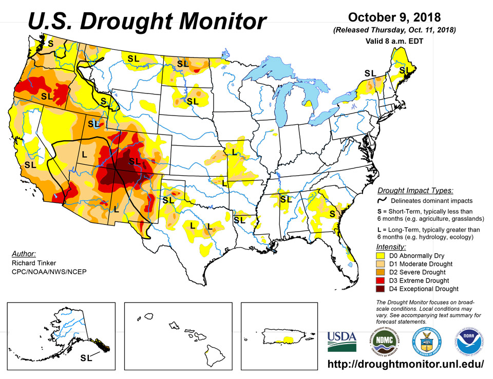
Source: National Drought Mitigation Center

