California and National Drought Summary for January 8, 2019
Summary
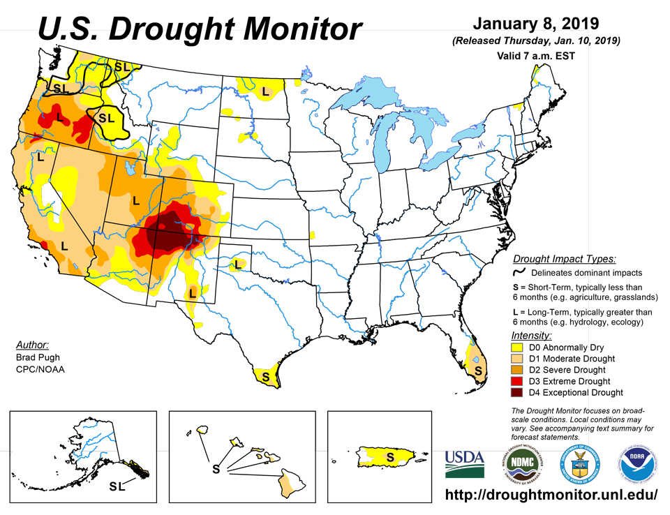
January 10, 2019 - A strong upper-level low resulted in surface low development along the western Gulf Coast on January 3. This low pressure system then tracked northeast to the mid-Atlantic by January 5, maintaining excessive wetness across much of the lower Mississippi Valley and Southeast. However, southern Florida remained mostly dry as short-term dryness worsened. Onshore flow returned to the West Coast by January 5, resulting in rain and high-elevation snow. Although widespread precipitation occurred across coastal areas of Washington, Oregon, and northern California, 7-day amounts averaged below normal north of Eureka, California. Above-average precipitation amounts were observed across the southern half of California and the Southwest. According to the Natural Resources Conservation Service (WYTD), snow water equivalent (as of January 7) is at or slightly below normal across Arizona and New Mexico basin-wide for the water year. As an area of upper-level low pressure shifted east across the western U.S., a surface low and associated warm front crossed the Midwest and Great Lakes on January 7. The heaviest weekly amounts (more than 1 inch, liquid equivalent) were recorded from Wisconsin north to the upper peninsula of Michigan.
Northeast
Occasional light precipitation was observed across the Northeast and ACIS indicates that amounts were at or above normal for a majority of this region. Based on 28-day USGS streamflows averaging above normal (76-90th percentile) and 90-day SPI values near or above normal, abnormal dryness (D0) was removed from New York. Since 7-day precipitation amounts averaged below normal across northern Vermont and northwest Maine, those existing D0 areas were maintained.
Southeast
Widespread rainfall (0.5 to 2 inches) accompanied a low pressure system as it tracked across the Tennessee Valley on January 3 and 4. This rainfall maintained saturated soils with soil moisture rankings above the 95th percentile throughout much of this region, along and north of the Gulf Coast. Soil moisture ranks in the highest 99th percentile from the southern Appalachians north to the mid-Atlantic. Minor to moderate river flooding continues across the eastern Carolinas, southern Georgia, the Florida Panhandle, and parts of Alabama. A trailing cold front triggered scattered convection with rainfall amounts of 0.5 to 1 inch across central Florida, but southern Florida remained mostly dry. 90-day rainfall deficits ranged from 4 to 8 inches from West Palm Beach south to Miami. As of January 7, water levels in Lake Okeechobee were approximately 2 feet below normal. Since it is typically dry this time of year, there are no impacts apparent at this time to support the introduction of severe drought (D2). This area will be closely monitored for future degradation.
South
Widespread moderate to heavy precipitation (0.5 to 2.5 inches, liquid equivalent) fell across the lower Mississippi Valley and parts of the southern Great Plains for the second consecutive week. The recent precipitation during an ideal time of year for soil moisture recharge resulted in the removal of any lingering abnormal dryness (D0) across northeast Oklahoma and northwest Arkansas. However, the long-term drought area in the Texas Panhandle remained mostly west of the heavier precipitation and south Texas remained dry during the past week. Short-term abnormal dryness (D0) and moderate drought (D1) were expanded in southern Texas where 90-day deficits ranged from 1 to 4 inches.
Midwest
Although little to no precipitation (less than 0.5 inch) was observed during the past week, this region remains drought-free as 90-day precipitation has averaged at or above normal. USGS 28-day average stream flows continued above the 75th percentile (above normal) throughout the region. A small area of abnormal dryness (D0) exists across northwestern Minnesota where the ground is frozen and snow-covered
High Plains
Following a week of widespread snowfall, mostly dry weather prevailed across the northern and central Great Plains. Based on a reassessment of departure from normal precipitation at varying time ranges (60 days to 6 months), moderate drought was reduced in coverage across North Dakota and limited to areas with the largest deficits. Elsewhere, across the Dakotas, no changes were made to the ongoing D0 areas.
West
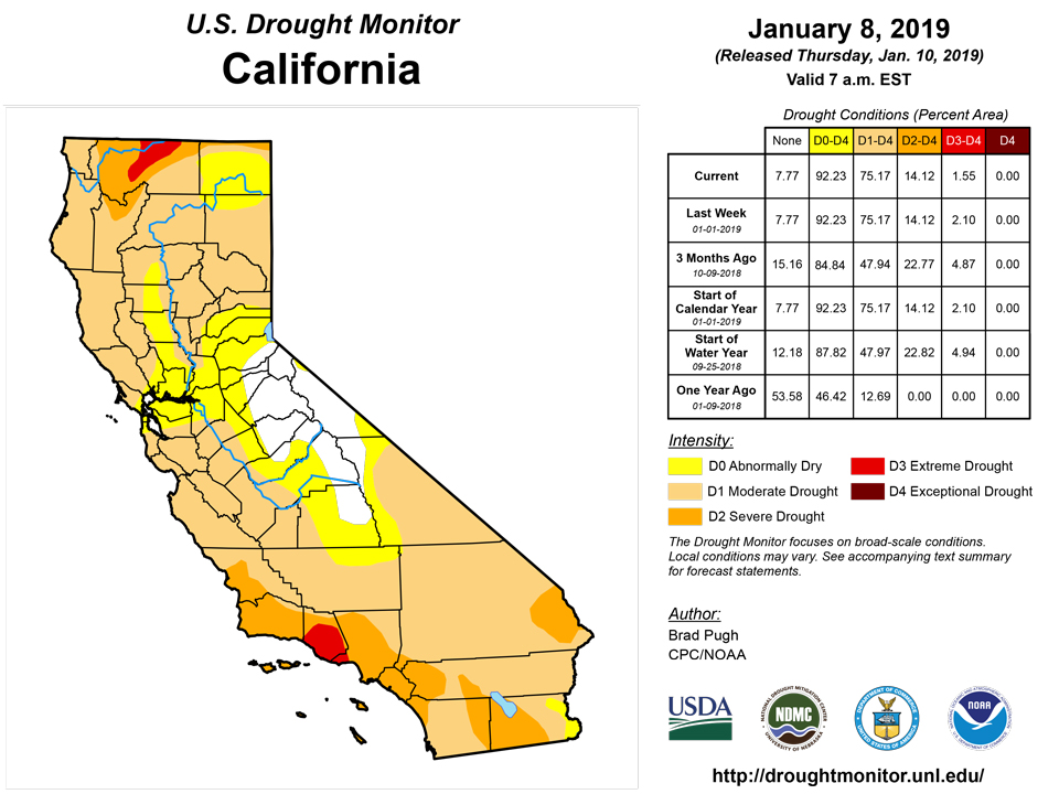
Beneficial precipitation, with locally heavy high-elevation snow, continued across the Four Corners region into the first week of the New Year. Based on recent precipitation, near to above-average precipitation during the past 6 months, and SPI values near normal, abnormal dryness was removed from southeast Arizona with a slight reduction in the coverage of D1 and D2 where recent amounts were heaviest. Small areas of improvement also were made across southwest Colorado. Cortez in Montezuma County has received about an inch above normal precipitation since the beginning of the water year, supporting an upgrade from D4 to D3. In the San Luis Valley, recent precipitation prompted an improvement from D3 to D2. These areas of improvement are limited to the lower elevations since snowpack remains slightly below normal at the higher elevations. During the past week, local precipitation amounts exceeded 1 inch (liquid equivalent) in Unitah County, Utah where D3 was improved to D2. Farther to the north and east, little to no precipitation and above-average temperatures resulted in an increase in D1 across Adams and El Paso counties of north-central Colorado and an expansion of D0 from north-central Colorado into southern Wyoming. Abnormal dryness (DO) was removed from north-central Montana in early December. However, it has remained dry since that time and D0 may need to be reintroduced in the coming weeks.
Onshore flow continued to bring widespread rain and high-elevation snow to the West Coast during the first week of the New Year. However, ACIS indicates that precipitation has averaged below normal during the past 30 days across a majority of the Pacific Northwest and California. Santa Barbara and Ventura counties received another round of heavy precipitation (locally more than 2 inches) this past week, producing mud slides in burn-scarred hillsides. An increase in water storage on Cachuma Reservoir was noted. Based on recent precipitation and 12 to 24-month SPIs, a decrease in the coverage of D3 was made to these counties in southern California. According to SNOTEL, basin snow water content (SWE) remains below 75 percent of normal across the southern Cascades where D2 to D3 is designated. Recent heavy precipitation and only small precipitation deficits at 60 days prompted removal of abnormal dryness across parts of western Washington.
Alaska, Hawaii, and Puerto Rico
Precipitation averaged near to slightly above normal across the Alaska Panhandle during the first week of the New Year. Since 6-month precipitation deficits remain in excess of 16 inches across the ongoing long-term drought areas of the southeast Alaska Panhandle, no improvements were made this past week.
An expansion of abnormal dryness (D0) and moderate drought (D1) was based on continued dryness across the leeward sides of the Hawaiian Islands. Moderate drought was expanded on Kauai, Maui, and the Big Island, while it was introduced on western Oahu. The abnormal dryness was degraded to moderate drought on Lanai and Kahoolawe. This increase in coverage of D0 and D1 is consistent with a continuation of suppressed rainfall, typically associated with an emerging El Nino.
In Puerto Rico, mostly dry weather persisted with short-term deficits continuing to increase. D0 was expanded from the previous week to coincide with areas of below-average rainfall during the past 30 to 60 days. D1 was also expanded across the central interior and added to the southwest corner where 60-day rainfall has averaged 25 to 50 percent of normal. 28-day USGS averaged stream flows have dropped below the 25th percentile across scattered areas of the island.
Author(s):
Brad Pugh, NOAA/CPC
Dryness Categories
D0 Abnormally Dry—used for areas showing dryness but not yet in drought, or for areas recovering from drought.
Drought Intensity Categories
D1 Moderate Drought
D2 Severe Drought
D3 Extreme Drought
D4 Exceptional Drought
Drought or Dryness Types
S Short-Term, typically less than 6 months (e.g. agricultural, grasslands)
L Long-Term, typically greater than 6 months (e.g. hydrologic, ecologic)