


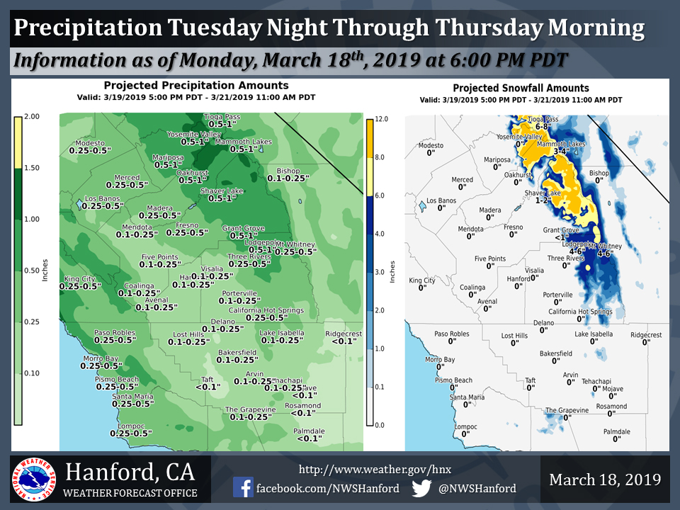
Projected rainfall totals for Mariposa: 0.50" to 1.00"
Projected rainfall totals for Oakhurst: 0.50" to 1.00"
Projected rainfall totals for Yosemite Valley: 0.50" to 1.00"
March 19, 2019 - The National Weather Service Hanford Office reports the next storm system will impact Central California Tuesday night through Thursday morning.
The majority of this projected precipitation will fall late Tuesday night and Wednesday. Snow levels should start at about 7,000 feet Tuesday night, before falling to around 5,500 feet Wednesday.
Snow levels should drop to near 5,000 feet Wednesday night into Thursday morning.
Per NWS:
 ...As for the onset of precipitation, the latest high resolution
  modeling holds off on any rain until around sunset over the
  western parts of the forecast area and over the Sierra Crest. The
  main band of rain looks to push quickly northeast into the area
  during the evening hours with lingering precipitation mainly
  affecting the Sierra overnight. The low pressure center associated
  with the trough is projected to lift northeast and just skirt the
  Bay Area during the late night and early morning hours on
  Wednesday. At this time the trough of low pressure becomes
  extremely negatively tilted with a pronounced northwest to
  southeast orientation. This leads to models forecasting a
  secondary low pressure center to move into Central California from
  the northwest on Wednesday night into Thursday morning with some
  colder air aloft with will increase instability. Some
  thunderstorm activity seems likely Wednesday afternoon and evening
  as this occurs. Shower activity will continue into Thursday
  evening before the secondary low moves east of the area and
  shortwave ridging moves in from the west on Friday.

  For the weekend, the next seemingly weaker trough of low pressure
  arrives on Saturday and the emphasis from this feature looks to be
  Northern California however at least a chance of some rain is
  possible well into Central California on Saturday. This system
  looks weak and very fast moving leaving Sunday high and dry under
  weak ridging. Models after the weekend diverge as to the timing
  and whether the next big Pacific low moves into the area on
  Tuesday and Wednesday per the GFS model or Wednesday through
  Thursday as advertised by the ECMWF model. Either way, the active
  wet season continues.
Source: NWS

