


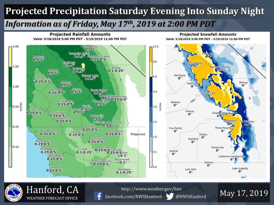
Projected rainfall totals for Mariposa: 1.00" to 1.50"
Projected rainfall totals for Oakhurst: 1.00" to 1.50"
Projected rainfall totals for Yosemite Valley: 1.00" to 1.50"
May 18, 2019 - The National Weather Service Hanford Office reports a storm system will impact Central California Saturday evening into Sunday night.
Periods of heavy snow are expected in the Southern Sierra Nevada above 6,000 feet, where a Winter Storm Watch is in effect.
Most precipitation will fall Saturday night and Sunday morning.
  Area Forecast Discussion
  National Weather Service San Joaquin Valley - Hanford CA
  320 AM PDT Sat May 18 2019

  .SYNOPSIS...
  Unsettled weather continues over the next few days with areas of
  rain, snow, and wind across central California. As a result, it
  will not feel like the middle of May. A few strong thunderstorms
  will also return to the San Joaquin Valley by Sunday afternoon.

  &&

  .DISCUSSION...
  After a mostly clear night, mid and high level clouds will spread
  back across the region today as the next low pressure system and
  cold front approach from the northwest. This system is looking
  similar in timing and strength to the system that moved through
  Thursday. Rain is expected to start over the northern part of the
  district by late this afternoon and spread south tonight. Much of
  the precipitation will fall tonight and into early Sunday morning.
  By Sunday afternoon the precipitation becomes convective as the
  atmosphere will be unstable with lifted indices forecasted to be
  between -2 and -3.5. Showers will continue Sunday night and into
  Monday morning over the south Valley and the mountains as the low
  exits the region, then just a few lingering showers over the
  Sierra Nevada Monday afternoon. Snowfall amounts from this system
  will range from 8 to 12 inches in the Sierra above 6000 feet, with
  up to 20 inches above 8000 feet. A winter storm warning has been
  issued from 5 pm today through 11 pm Sunday.

  We don`t get much of a break before the next system arrives on
  Tuesday. This system does not appear to have as much moisture with
  it as it moves inland over Oregon and Northern California before
  dropping south into Central California. However, it will still
  bring a chance of showers and afternoon/evening thunderstorms to
  area Tuesday. It looks like a trough of low pressure will remain
  over the region for the remainder of the week, keeping the weather
  unsettled. Showers look like they will mainly be over the Sierra,
  however, can not rule out a few showers on the east side of the San
  Joaquin Valley at times Wednesday or Thursday and have kept
  slight chance POPs for those periods.

  Temperature wise, it will be about 15 to 20 degrees cooler than
  normal at least through the middle of the week. That will put high
  temperatures in the San Joaquin Valley in the mid 60s to lower 70s
  through Wednesday. Temperatures are expected to warm gradually for
  the end of the week, but will remain below normal for mid to late
  May.
Source: NWS

