


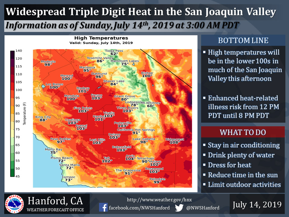
Projected high temperature for Mariposa on Sunday: 95 degrees
Projected high temperature for Oakhurst on Sunday: 96 degrees
Projected high temperature for Yosemite Valley on Sunday: 86 degrees
July 14, 2019 - The National Weather Service Hanford Office reports high temperatures this afternoon in much of the San Joaquin Valley will be in the lower 100s.
Most people have experience with this kind of heat and will instinctively know how to avoid heat-related problems.
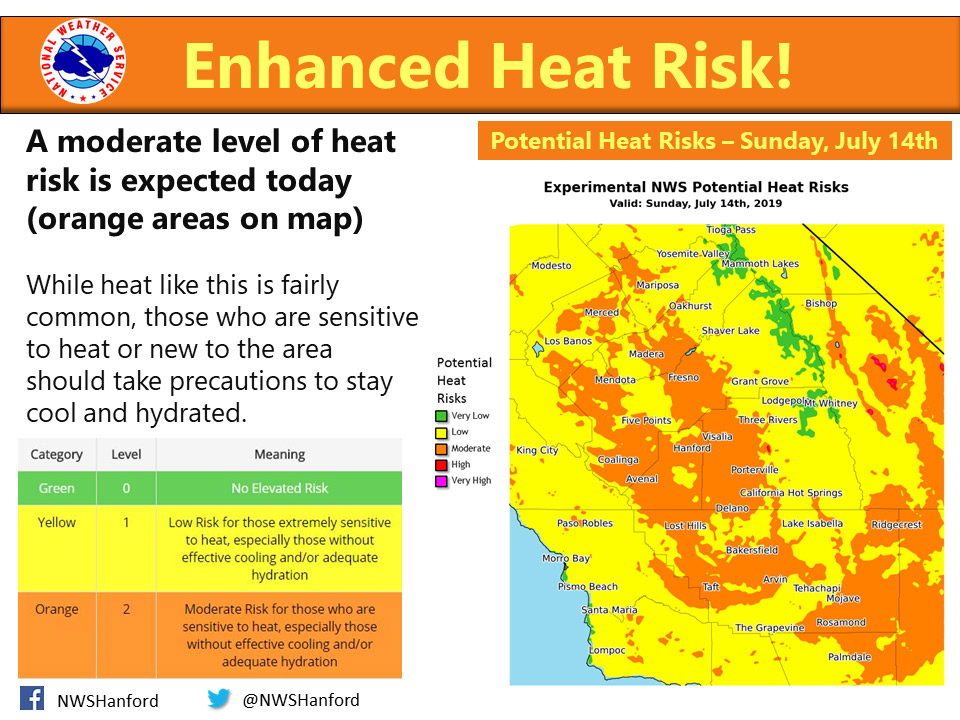
Although heat events like this are relatively common, heat-related impacts are possible today for those new to the area if simple precautions are not taken.
Plan to take action to reduce time outdoors, drink plenty of water, and remain in air-conditioned buildings.
Heat-sensitive groups, such as the elderly, young children, and those with chronic ailments may need assistance to avoid heat-related illness.
As always, never, ever leave a child or pet in an enclosed automobile.
  Area Forecast Discussion
  National Weather Service Hanford CA
  158 AM PDT Sun Jul 14 2019


  .SYNOPSIS...Expect little change in temperatures today due to
  a ridge of high pressure centered over the Four Corners region.
  A modest cooling trend early next week will bring temperatures
  to near normal by Tuesday with little day to day change for the
  remainder of the week. Otherwise, dry weather will prevail over
  the district for the next several days.

  &&

  .DISCUSSION...Quiet weather once again tonight across the central
  California interior. Satellite imagery shows clear skies currently
  and that will continue through the day as we heat up to well above
  normal temperatures again. This is due to an upper ridge of high
  pressure remains centered over the Four Corners region. Widespread
  triple digit heat will be felt across the San Joaquin Valley, the
  lower foothills, and the Kern County Desert. There will not be
  much help from a breeze today either as light winds will prevail.
  So there will be an enhanced heat risk once again today. Those
  who are sensitive to heat or new to the area are reminded to take
  precautions to stay cool and hydrated. Also, local rivers might
  seem like a great way to cool off, but they are very dangerous as
  the water remains cold and swift.

  Water vapor satellite imagery shows an upper trough just off the
  Pacific Northwest coast. This trough will push inland on Monday
  and deepen over California on Tuesday. This will produce cooling
  across the region with temperatures down a few degrees each day.
  Most of the SJV should stay just below the century mark Monday,
  but much of the Desert will probably still hit triple digits. By
  Tuesday highs are forecast to lower back to near normal with mid
  to upper 90s in the SJV. An increased onshore surface flow will
  also develop Monday, resulting in breezy conditions for much of
  the district through Tuesday. Windy conditions are likely through
  and just below mountain passes in the Kern County Mountains and
  Desert.

  The trough then flattens out by Friday with a fast zonal flow
  aloft over the PacNW and light winds aloft over central CA. The
  aforementioned upper ridge tries to build back west a bit but
  stays centered over the southern Plains later in the week. So
  with no major change in air mass, expect only minor fluctuations
  in temperatures through the remainder of the week. As we move
  into next weekend the models want to bring another trough over
  the PacNW for further cooling. Right now only slight cooling is
  forecast with highs just a touch below normal next weekend.
Source: NWS

