


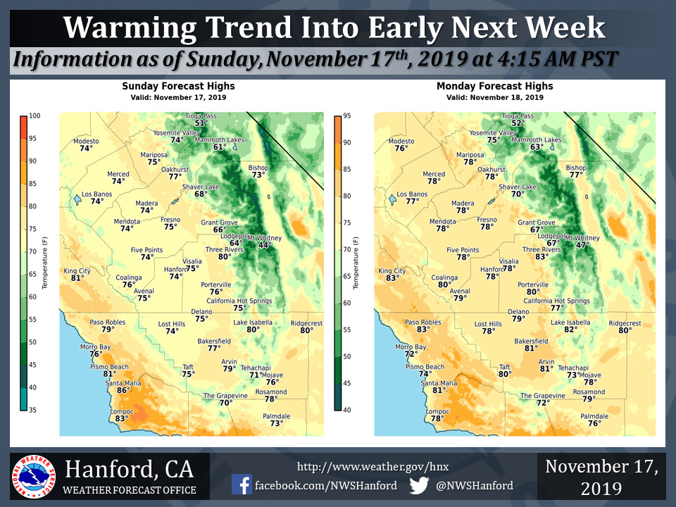
Mariposa projected high temperature for Sunday: 75 degrees, Monday: 78 degrees
Oakhurst projected high temperature for Sunday: 77 degrees, Monday: 78 degrees
Yosemite Valley projected high temperature for Sunday: 74 degrees, Monday: 75 degrees
November 17, 2019 - The National Weather Service Hanford Office reports near record warmth is likely in the San Joaquin Valley Monday afternoon.
The current record for maximum temperature ever measured in Fresno on November 18th is 80 degrees, initially established in 1932 and last observed in 2008.
Temperature records at Fresno date back to 1887. The current record for maximum temperature ever measured in Bakersfield on November 18th is 83 degrees, set in 1926.
Temperature records at Bakersfield date back to 1893.
  Area Forecast Discussion
  National Weather Service Hanford CA
  425 AM PST Sun Nov 17 2019


  .SYNOPSIS...
  Dry weather will continue over the district through Tuesday. Above
  normal afternoon temperatures can be expected today and Monday. A
  cooling trend will occur for the remainder of the week with the
  possibility of wet weather from Tuesday night into Thursday night,
  especially over the mountains and desert.

  &&

  .DISCUSSION...
  A ridge of high pressure is nosing inland across central CA while
  a weak upper low slips southward toward southern Baja. Some high
  clouds are spilling over the ridge but our skies are mostly clear
  and we can expect just some patchy fog in the San Joaquin Valley
  this morning with seasonably cool morning lows.

  Dry conditions will continue today and Monday with temperatures
  trending upward beneath the building ridge. By Monday, highs
  should reach around 10 degrees above climo.

  Tuesday will be the beginning of a significant change in
  conditions over our area as models show a developing trough
  dropping southeast from the Pacific Northwest region while the
  Baja low drifts northeast. The first effect will be slightly
  lower afternoon highs on Tuesday. By later Tuesday night we will
  have a chance for some precip in the desert and mountain areas as
  the trough slides south and develops an upper low near the central
  CA coast while the Baja low lifts toward the southwest US.

  Models are quite similar as they continue to swing the developing
  low pressure system into the southwest US Wednesday into Thursday.
  This will mean precipitation chances across our area Wednesday,
  especially over the mountain and desert areas, and lingering into
  Thursday evening over the mountain and desert zones.

  Latest total QPF guidance shows around 1 to 4 tenths of an inch in
  the desert and ranges from around 1/4 to 3/4 of an inch of liquid
  in the mountains. Amounts in the SJ Valley range from a trace near
  Merced County to as much as 2 to 3 tenths in the south and east.
  Snow level will be mostly around 7000 ft and above, falling as low
  as 5500-6000 ft by Thursday as the precip is winding down. Several
  inches of accumulating snow will be possible at the higher
  elevations Wednesday into Thursday. Temperatures will also be
  significantly lower with the incoming system, down to around 4-8
  degrees below normal for Wednesday and Thursday.

  The end of the week and through next weekend will see a return to
  drier conditions behind the departing low pressure system, with
  temperatures gradually increasing to around seasonal averages.
  We can also expect to see more significant fog development in the
  Valley after the addition of some moisture from the passing
  system.
Source: NWS

