


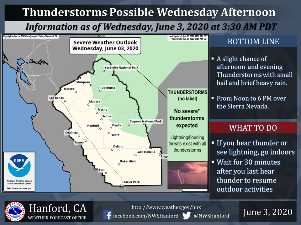
A chance of Thunderstorms today for Eastern Mariposa County including Yosemite National Park and Eastern Madera County including Oakhurst
June 3, 2020 - The National Weather Service Hanford Office reports a few strong thunderstorms are possible across the Sierra Nevada Wednesday afternoon and evening.
Small hail, brief heavy rain and wind gusts near 45 miles per hour are some of the hazards associated with strong thunderstorms.
In addition to dangerous cloud to ground lightning strikes, any thunderstorm can produce localized flooding.
  Area Forecast Discussion
  National Weather Service Hanford CA
  252 AM PDT Wed Jun 3 2020

  .SYNOPSIS...
  Well above normal afternoon temperatures can be expected over the
  region during the next few days with a return of triple digit
  heat in the San Joaquin Valley, lower foothills and desert
  today and Thursday. Isolated afternoon thunderstorms are possible
  over the high Sierra Wednesday and Thursday. A cooling trend will
  begin Friday accompanied by showers and isolated thunderstorms
  over mainly the higher terrain. The weekend will be much cooler
  with gusty winds.

  &&

  .DISCUSSION...
  Closed upper level low pressure centered off of Baja California
  has been streaming mid and high level clouds over the region for
  the past several days. The clouds have been wreaking havoc on the
  Max temperature forecast for the past couple of days and
  yesterday was no different. Many areas in the SJV where the clouds
  were, barely broke 90 degrees. However, areas to the north where
  it cleared out were in the mid to upper 90s. It was 94 at Los
  banos and 91 at Bakersfield...very unusual temperature pattern.
  Unless you have cloud cover.

  The upper low is drifting west and is expected to take its clouds
  with it today. So I have a bit more confidence with the Max
  temperatures today and tomorrow. Tomorrow looks to be the hottest
  day as the four corners ridge will build west and heat us up.
  Guidance has been running warm but it has been consistent with the
  forecast over the past several runs. We are seeing a surge of
  moisture that will impact the Sierra today with showers and
  thunderstorms this afternoon. We are seeing the showers and
  thunderstorms waning on Thursday and increasing again on Friday.

  Once we get through the next couple of days and the hot spell over
  the region, we can look forward to a significant cooldown by
  Sunday. At least a 25 to 30 degree swing from high temperatures
  on Thursday to high temperatures on Sunday will remind us that it
  is still spring in the Central California Interior. Friday we will
  see the front pushing through later in the evening and we will
  see an increase in showers and thunderstorms...mainly in the
  Sierra and even in the Kern mountains. We will also see an
  increase in winds across the coastal range and through the Kern
  county mountains that will continue into Saturday and possibly
  Sunday. A rapid warming trend is expected early next week as we
  see Max temps rise from the mid 70s in the SJV on Sunday to back
  into the mid 90s by Wednesday. It is expected to be dry early
  next week as an upper level ridge builds back in to the region.
  The rollercoaster ride of hot to cool back to hot again is pretty
  normal for this time of year. But at least the hot spells are
  short this time of year. Next couple of months will be a different
  story.
Source: NWS

