


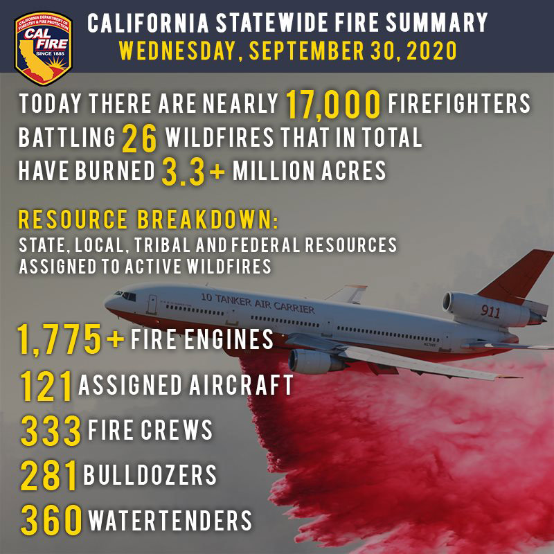
September 30, 2020 - As wind conditions improved yesterday, crews brought final containment to the Fox Fire in Siskiyou County, and over 17,000 firefighters worked to gain ground on the remaining 26 major wildfires across the state. Crews across the State also responded to 26 new wildfires, with only the Candy Fire in Riverside County growing beyond control of the initial response.
Since the beginning of the year, there have been over 8,100 wildfires that have burned well over 3.9 million acres in California. Sadly, 29 fatalities have occurred and over 7,200 structures have been destroyed.
Elevated temperatures and low humidity levels continue across much of California through the week. A Fire Weather Watch is in effect beginning this evening in Monterey County and the North Bay, potentially affecting the Glass Fire. Locally gusty winds could be experienced in the Sierra and associated foothills, and southern California mountain regions. A cooling trend is expected to arrive over the weekend, lowering temperatures and raising humidity.
California historically experiences some of the most devastating wildfires in the months of September and October. Do not let your guard down! To learn more ways on how to prevent sparking a wildfire, visit www.ReadyForWildfire.org
Fires of Interest:
**CAL FIRE Incidents**
Zogg Fire, Shasta County (more info…)
Southwest of Redding
*51,955 acres, 7% contained
*3 Fatalities
*Evacuation orders in place
*146 structures destroyed
*CAL FIRE Team 2 in command
Glass Fire, Napa County (more info…)
4 miles east of Calistoga
*48,440 acres, 2% contained
*Evacuation orders in effect and additional evacuations in progress
*CAL FIRE Team 3 in command today
LNU Lightning Complex, multiple North Bay counties (more info…)
Napa, Lake, Sonoma, Colusa, Solano, and Yolo Counties
*363,220 acres, 98% contained
*While no growth is expected, fire suppression repair work is ongoing.
SCU Lightning Complex, multiple Easy Bay counties (more info…)
Contra Costa, Alameda, Santa Clara San Joaquin, Merced, and Stanislaus Counties
*396,624 acres, 98% contained
*While no growth is expected, fire suppression repair work is ongoing.
Butte/Tehama/Glenn (BTU/TGU) Lightning Complex, multiple Counties (more info)
Butte, Tehama, and Glenn Counties
*19,609 acres, 97% contained
*14 structures destroyed
*While no growth is expected, fire suppression repair work is ongoing.
**Unified Command Incidents**
North Complex, Plumas County (more info…)
Northeast of Oroville to southwest of Quincy (Plumas National Forest)
*314,949 acres, 79% contained
*15 fatalities
*2,342 structures destroyed
*Evacuations in place
*Includes the Bear and Claremont Fire
*CAL FIRE Team 4 is in unified command with US Forest Service IMT Team 4, Butte County Sheriff’s Office and California State Parks
Martindale Fire, Los Angeles County (more info…)
Bouquet Canyon, Northeast of Santa Clarita
*230 acres, 20% contained
*Structures threatened
*Evacuation orders remain in place
*Unified Command USFS and Los Angeles County FD
Creek Fire, Fresno County (more info…)
Northeast of Shaver Lake (Sierra National Forest)
*307,051 acres, 44% contained
*Evacuations in place
*Heavy tree mortality in the area
*855 structures destroyed
*CAL FIRE Incident Management Team 1 in unified command with USFS Great Basin Team 1
SQF Complex, Tulare County (more info…)
3 miles east of Giant Sequoia National Monument
*151,426 acres, 61% contained
*Evacuations in place
*232 structures destroyed
*CAL FIRE Incident Management Team 6 in unified command with USFS Team 2
**Coordinated Command Incidents**
August Complex, multiple Counties (more info…)
Colusa, Glenn, Lake, Mendocino, Tehama and Trinity Counties
Elk Creek and Stonyford area (Mendocino National Forest)
*949,055 acres, 47% contained
*South Zone 489,151 acres, 70% contained
*North Zone 341,488 acres, 37% contained
*West Zone 118,416 acres, 65% contained
*1 fatality
*86 structures destroyed
*Includes multiple fires including the Elkhorn, Hopkins, Willow, Vinegar, and Doe fires
*Pacific North West Team 2 in command of the South Zone
*Alaska Incident Management Team 1 is in command of the North Zone
*CAL FIRE Incident Management Team 5 is in unified command on the West Zone
**Federal Incidents**
Snow Fire, Riverside County (more info…)
Snow Creek Rd, west of Palm Springs
*6,254 acres, 95% contained
El Dorado Fire, San Bernardino County (more info…)
West of Oak Glen (San Bernardino National Forest)
*22,744 acres, 93% contained
*1 fatality
*10 structures destroyed
*California Interagency Incident Management Team 13 in command
Fox Fire, Siskiyou County (more info…) FINAL
7 miles southwest of Callahan
*2,188 acres, 100% contained
Slater Fire, Siskiyou County (more info…)
5 miles North of Happy Camp (Klamath National Forest)
*154,145 acres, 45% contained
*2 fatalities
*Evacuation orders in place
Devil Fire, Siskiyou County (more info…)
5 miles north of Upper Devil’s Peak (Klamath National Forest)
*8,410 acres, 20% contained
Bobcat Fire, Los Angeles County (more info…)
North of Duarte (Angeles National Forest)
*114,202 acres, 62% containment
*Evacuations in place
Dolan Fire, Monterey County (more info…)
Hwy 1, 10 miles south of Big Sur (Los Padres National Forest)
*124,924 acres, 87% contained
*Structures threatened
*California Interagency Incident Command Team 15 in command
Bullfrog Fire, Fresno County (more info…)
SE of Bullfrog Lake (Sierra National Forest)
*1,185 acres, 50% contained
Fork Fire, El Dorado County, (more info…)
15 miles northeast of Pollock Pines (El Dorado National Forest)
*1,667 acres, 70% contained
Apple Fire, Riverside County (more info…)
Oak Glen/Cherry Valley (San Bernardino National Forest)
*33,424 acres, 95% contained
Red Salmon Complex – Humboldt County (more info…)
14 miles northeast of Willow Creek (Shasta-Trinity National Forest)
*120,236 acres, 31% contained
Blue Jay Fire, Mariposa County (more info…)
Yosemite National Park Wilderness
*4,673 acres, 50% contained
Wolf Fire, Tuolumne County (more info…)
Yosemite National Park Wilderness
*1,092 acres, 35% contained
Woodward Fire, Marin County (more info…)
3 miles southwest of Olema (Point Reyes National Seashore)
*4,929 acres, 97% contained
Slink Fire, Mono County (more info…)
2 miles west of Coleville (Humboldt-Toiyabe National Forest)
*26,759 acres, 86% contained
Moraine, Tulare County (more info…)
Sequoia and Kings Canyon National Parks Wilderness
*668 acres, 70% contained
Rattlesnake, Tulare County (more info…)
Sequoia and Kings Canyon National Parks Wilderness
*4,070 acres, 0% contained
**Extended Attack**
Candy Fire, Riverside County (more info…) NEW
Candy Lane, Southeast of Lake Mathews Reservoir
*227 acres, 95% contained
Top 20 Wildfire Records
- 5 of the Top 20 largest wildfires in California History have occurred in 2020.
- Largest Wildfires - #1 August Complex, #3 SCU Lightning Complex, #4 LNU Lightning Complex, #5 North Complex, and #6 Creek Fire.
- Most Destructive - #5 North Complex, #10 LNU Lightning Complex, #11 CZU Lightning Complex, and #17 Creek Fire.
- Deadliest Wildfires - #5 North Complex and #20 LNU Lightning Complex.
Source: CAL FIRE

