


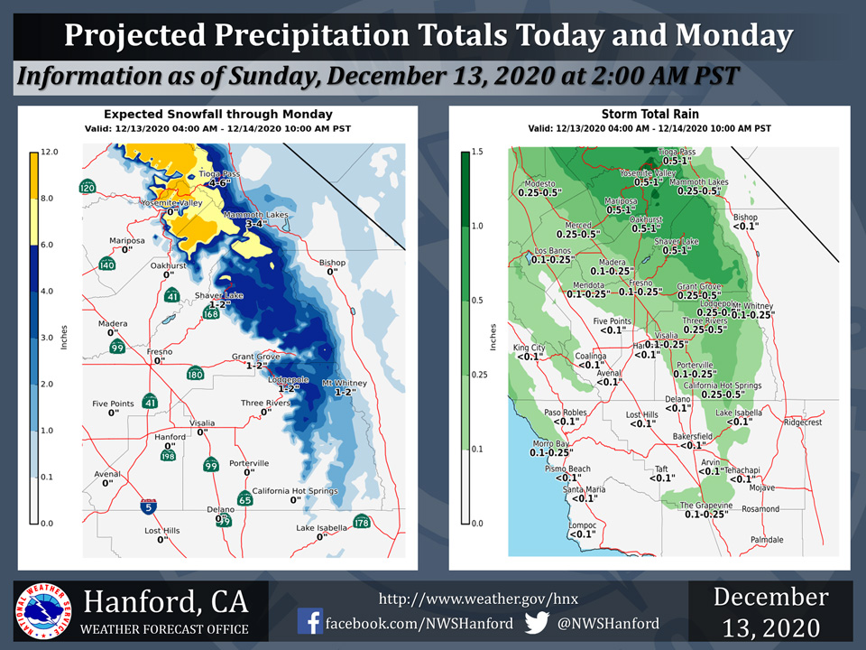
Projected rainfall totals for Mariposa: 0.50" to 1.00"
Projected rainfall totals for Oakhurst: 0.50" to 1.00"
Projected rainfall totals for Yosemite Valley: 0.50" to 1.00"
December 13, 2020 - The National Weather Service Hanford Office reports rain and higher elevation snowfall will impact Central California during this morning until Monday.
For Fresno County northward, expect general snowfall amounts of 3 to 8 inches, with locally higher amounts around 10 inches are possible above 6,000 feet by Monday morning.
Lesser snow amounts are likely south of Fresno County, or around 1 to 3 inches.
Rainfall totals of 0.10” to 0.25” are possible in portions of the San Joaquin Valley.
Precipitation totals of 0.25” to 1.00” are possible in the Sierra foothills, as well as in the higher elevations of the Sierra Nevada through late Monday morning.
  Area Forecast Discussion
  National Weather Service Hanford CA
  409 AM PST Sun Dec 13 2020


  .SYNOPSIS... A storm system will move through the area today into
  early Monday morning, bringing rain to the valley and
  accumulating snow to the Sierra above 6,500 feet. Weak ridging
  will move into the region on Tuesday and Wednesday with a slight
  increase in temperatures. Another system will impact the region on
  Thursday, followed by clearing conditions by the weekend.


  .DISCUSSION...Current Nighttime Microphysics satellite imagery is
  showing a fair amount of mid to upper level cloud cover across
  the Central California interior, along with low stratus covering
  much of the SJV. For this reason, I am not expecting any
  widespread dense fog across the valley this morning. Some areas
  that have seen some clearing are in Kern county as well as the
  eastern portions of the valley. Patchy fog development is
  possible in these areas by day break.

  A storm system is still poised to move into the region today.
  Rain will move into the Merced area by late morning. Showers will
  then move into the southern end of the valley by the afternoon
  and early evening hours. Rainfall amounts in the valley for this
  system will range from 0.10-0.25" in Merced county and the
  eastern portions of the SJV. Between nothing to 0.10" is possible
  in the western SJV and Kern County where the rain shadow effect
  will be more pronounced.

  Heavy rain and snow above 6,500 feet is likely today in the
  Sierra, with precipitation reaching the Yosemite area by late
  morning. Rain and snow will then move south into Fresno, and
  eventually into Sequoia National Forest by the afternoon. A Winter
  Weather Advisory will go into effect for the central Sierra this
  morning and will continue into Monday morning. Total snow amounts
  of up to 10" are possible, with lesser amounts as you go south
  into Fresno/Tulare county mountains. Precipitation totals in the
  mountains will generally bebetween 0.50-1.0" to locally 1.5" for
  areas north of Fresno county into Yosemite. Between 0.50-1.0" is
  possible from Fresno county south into Sequoia National Forest.
  Precipitation amounts for the central Sierra foothills will range
  from 0.50" to locally 1.0", with decreasing amounts as you go
  south into the Kern/Tulare County foothills. The Kern County
  mountains will see between 0.10-0.25", with no precipitation in
  the desert. The area will clear out for Monday with the exception
  of the Kern County foothills and mountains where northwesterly
  flow will push low clouds/stratus and drizzle for most of Monday.

  Weak ridging will move into the region on Tuesday into late
  Wednesday, with a slight increase in afternoon temperatures. With
  all the recent rain and clear nights, fog developing will be
  possible during Tuesday and Wednesday mornings.

  Models are better agreement with a trough digging south into the
  central Great Basin by Thursday. This will mean another round of
  snow for the Sierra and rain for the valley. Ridging sets up for
  Friday and Saturday, with fog possible in the valley both
  mornings.
Source: NWS

