


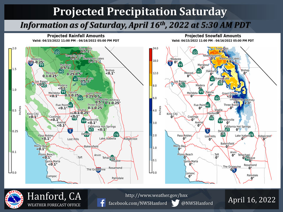
Projected Precipitation for Mariposa 0.25" - 0.50" 0.50"-1.00"
Projected Precipitation for Oakhurst 0.25" - 0.50"
Projected Precipitation for Yosemite Valley 0.50" - 1.00"
April 16, 2022 - The National Weather Service Hanford Office reports a trough of low pressure will pass across Central California today.
Precipitation is likely north of Kern County ahead of and along this trough.
A Winter Weather Advisory is in effect for elevations above 6,000 feet in the Sierra Nevada.
  Area Forecast Discussion
  National Weather Service Hanford CA
  348 AM PDT Sat Apr 16 2022


  .SYNOPSIS...
  A storm system will bring light valley rain and some high
  elevation snow today, along with strong winds in the Mojave
  Desert. Dry and warmer for Sunday and Monday then a couple of
  disturbances possible next week, with a chance of precip by the
  end of next week.

  &&

  .DISCUSSION...
  We are tracking a weather maker that will bring light precip to
  the CENCAL interior today. Snow levels will drop to around 6000
  feet with up to a foot of snow expected. Not much in the way of
  any wetting rain is expected across the SJV today because most
  areas will get below 0.10". Little or no rain is expected in Kern
  county. We are expecting some gusty winds across the desert area
  of Kern county through this evening.

  Once this system moves out of the area by later tonight, weak
  ridging will build in over the area Easter Sunday and on Monday,
  which will lead to highs warming back up into the upper 70s. This
  trend will be short lived as a system by the middle of next week
  knocks afternoon highs down a couple of degrees. A stronger system
  may be in store for Central California by the end of next week,
  which could bring more valley rain and high elevation snow.

  &&

  .AVIATION...
  Wind gusts up to 50 kts over the Kern County mountains after 12z
  Saturday through 04z sunday. Mountain obscuration in snow and rain
  across the Sierra through 06z sunday. Otherwise, VFR conditions
  will prevail over the Central California Interior for the next 24
  hours.

  &&

  .AIR QUALITY ISSUES...
  None.
Source: NWS

