


California and National Drought Summary for May 24, 2022
Summary
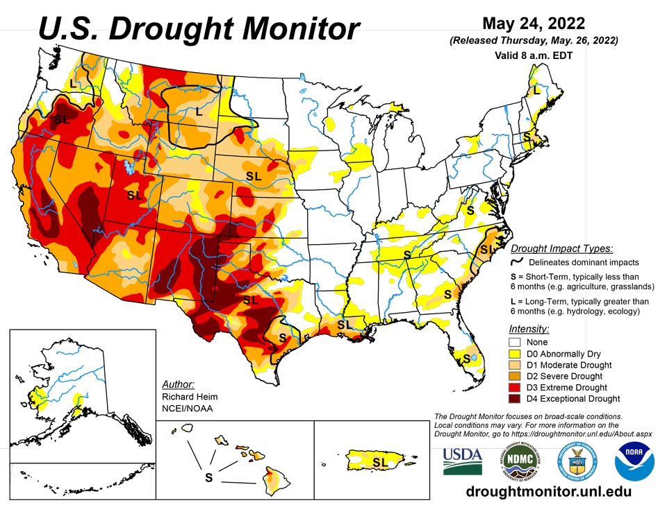
May 26, 2022 - A strong upper-level trough moved across the contiguous U.S. (CONUS) during this U.S. Drought Monitor (USDM) week (May 18-24). Surface low pressure systems and cold fronts were associated with this complex trough. They tapped Gulf of Mexico moisture to spread above-normal precipitation across parts of the Plains, Midwest, Southeast, and Mid-Atlantic Coast, and locally heavy snow across parts of Colorado. One of the fronts moved very slowly across the southern Plains near the end of the week, dumping locally heavy rain on parts of Oklahoma and Texas. Precipitation also fell across parts of the Pacific Northwest, North Dakota, and western Great Lakes. Most of the West was drier than normal, with much of the area from Oregon to California and southern Idaho to New Mexico receiving little to no precipitation. Weekly temperatures averaged below normal behind the fronts from the Pacific Northwest to Great Lakes and from the northern Rockies to Mid-Mississippi Valley. Temperatures averaged warmer than normal across the eastern third of the CONUS and from California to Texas. The continued lack of precipitation in the dry areas further dried soils, lowered stream levels, and stressed crops and other vegetation, while the warmer-than-normal temperatures increased evapotranspiration that added to the stress caused by lack of precipitation. But widespread heavy rain fell across several drought areas, contracting drought and abnormal dryness, especially in the central to southern Plains, Lower Mississippi Valley, Southeast, and Mid-Atlantic states. Drought and abnormal dryness also shrank in the Pacific Northwest where drought indicators showed improving conditions. Drought or abnormal dryness expanded or intensified where it continued dry, especially in southern parts of the West, in the Ohio and Tennessee Valleys, and parts of southern New England.
Northeast
An inch or more of rain fell across southern, western, and northern parts of the Northeast this week, with less than half of an inch falling over interior regions from western Pennsylvania to southern Maine. The rain was enough to remove abnormal dryness from Vermont and New Hampshire, but moderate drought continued in northern Maine and part of West Virginia, while D0 expanded in western New York and southern New England. Dry conditions over the last 60 days, plus low groundwater and streamflow, prompted the introduction of moderate drought over eastern Massachusetts and part of Rhode Island.
Southeast
A cold front and surface low pressure system moved across the Southeast just as the USDM week ended. They generated widespread rain across the Southeast, with amounts exceeding 2 inches over western North Carolina to southwest Virginia, parts of Alabama to South Carolina, and parts of Florida. Wholesale contraction of D0 followed, along with trimming of some D1 and D2. But part of North Carolina missed out on the rain, so D2 expanded in the southern Coastal Plain.
South
A large part of Oklahoma and parts of Texas and Louisiana were inundated with several inches of rain, over 6 inches in places. Zapata County in southern Texas received about half a year of normal rainfall this week. Heavy rain in central and northern Oklahoma, and in the Texas panhandle, southern Texas, and southeast Texas, resulted in the contraction of abnormal dryness and moderate to exceptional drought. Abnormal dryness contracted in Arkansas, D0 and D1 contracted in Mississippi, and D0-D3 shrank in Louisiana. Other parts of the South region were dry. D2-D4 expanded in parts of central to northeast Texas, D0 expanded in Mississippi and Tennessee, and a spot of moderate drought was added in eastern Tennessee.
Midwest
Two inches or more of precipitation fell across southern portions of the Midwest in a band from Missouri to Ohio and across southeastern Minnesota into Wisconsin, while parts of Iowa and Minnesota received less than half an inch of rain. Abnormal dryness expanded in Kentucky and into southern Illinois where this week was drier than normal and precipitation deficits have been building over the last couple months.
High Plains
Two inches or more of precipitation fell across southern and eastern parts of Kansas, central Colorado, and northeast Nebraska, while half an inch or more was widespread across North Dakota. Parts of Nebraska, northeast Colorado, Wyoming, South Dakota, and eastern Montana received less than half an inch of precipitation. In Colorado, moderate to extreme drought contracted where it was wet, while severe and extreme drought expanded where it was dry. Abnormal dryness and moderate to extreme drought shrank in parts of Kansas. The rain ate a hole into severe drought in northeast Nebraska. Abnormal dryness and moderate drought were trimmed in western North Dakota. On the other hand, it was a dry week in western Wyoming with D3 expanding in Teton County.
West
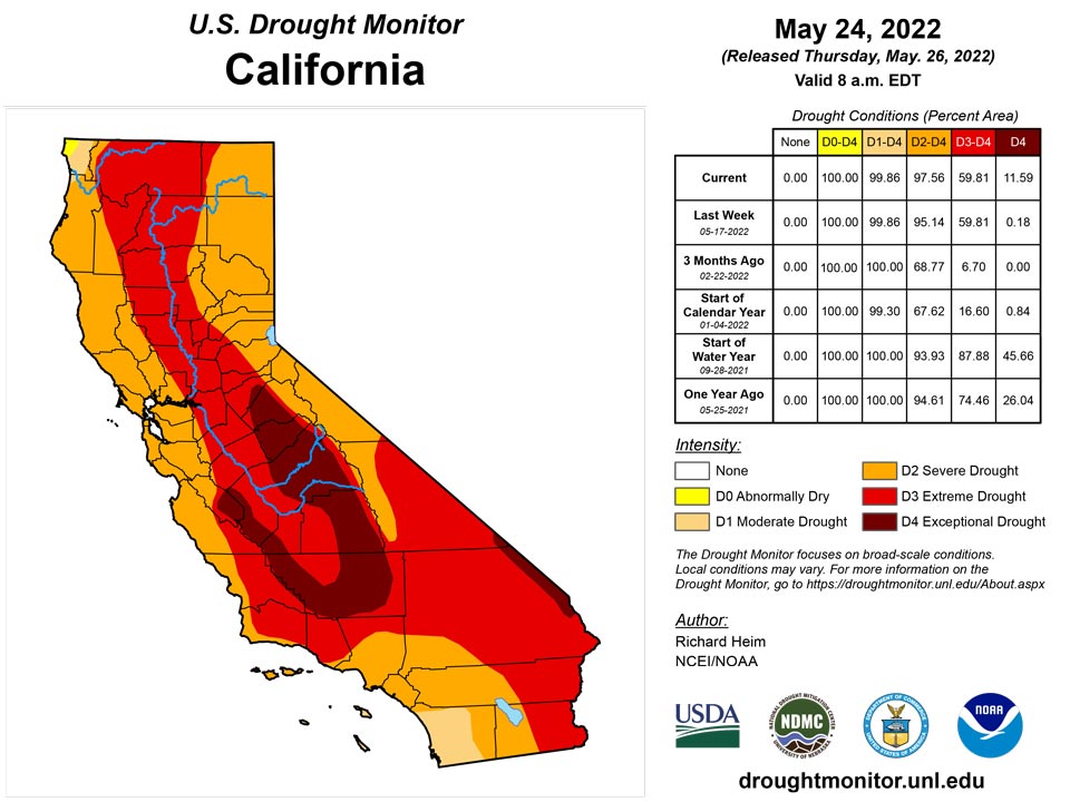
Half of an inch or more of precipitation fell in the Coastal and Cascade ranges of the Pacific Northwest, and northern to central Rockies. But more southerly parts of the West, from southern Oregon to New Mexico, received no precipitation. Abnormal dryness to severe drought were trimmed in Washington, Oregon, Idaho, and Montana. Extreme drought shrank in southwest Montana, while exceptional drought was trimmed in Oregon. Some of the drought contraction was due to drought indicators showing slightly less severe conditions. In the drier areas of the West, D3-D4 expanded in New Mexico, D2-D3 expanded in Arizona, D3 spread in Utah and adjoining parts of Idaho and Wyoming, and D2 expanded in southern California with slight expansion of D4 from adjoining southern Nevada. Arms of exceptional drought were added to the San Joaquin Valley in California where the National Weather Service noted that dry conditions continue throughout the area; snow cover is virtually non-existent below 8,000 feet; peak flow through area rivers and inflow into the reservoirs has already occurred or will occur soon, weeks ahead of normal; and applications for grants for well drilling, purchasing tanks, and bottled water recipients are increasing. In southern California, the Coastal Fire broke out on May 11th in Orange County near Laguna Niguel. Windy conditions spread it rapidly upcanyon where it burned 200 acres, destroyed 20 homes, and damaged 12 others. Near-record dry fuels around the May 11th time frame set the stage for this fire.
Caribbean
Locally over 2 inches of rain fell over parts of western and northeastern Puerto Rico, mostly on the last day of this USDM week. But other parts of the island received considerably less rain, and even the rain that fell was mostly below normal for the week. D1 expanded in south central coastal areas of Puerto Rico where soil moisture is very dry and streamflow much below normal to record low.
Drier than normal conditions have continued across the U.S. Virgin Islands this week. On St. Thomas, only 0.76 inches of rain was reported at Cyril E. King Airport. Though a slight increase in the water level was observed on May 24 (due to recent rain), groundwater is still well below the normal water level. So, moderate short- and long-term drought conditions continued this week. St. John was also dry this week. Only 0.03 inches of rain at Windswept Beach was reported this week. Groundwater levels have also continued to recede this week. Thus, moderate short- and long-term drought conditions have continued. Similarly, St. Croix reported only 0.01 inches of rain this week, and groundwater levels continued to recede in the past few weeks so that it remained in extreme short- and long-term drought conditions.
Pacific
D0 expanded in southwest Alaska and a new area of D0 was added in south central Alaska where precipitation deficits have built over the last 2 months.
A late season low pressure system dropped rain over parts of Hawaii this week. One-category improvements in drought status were made on Kauai and Niihau, western and southern parts of Oahu, and northwest Molokai. On the other hand, Maui continued dry this week with D0 expanding along the east-facing slopes of the West Maui mountains.
This week, Pago Pago reported 0.92” of rain. Last week, 6.27 of rain was observed at Pago Pago. In addition, this week, Siufaga Ridge and Toa Ridge observations (both NPS in American Samoa) were 1.89” and 2.0”, respectively. However, because American Samoa had wet conditions last week, it remained free of dryness.
Wet conditions prevailed this week across the Republic of Palau. Palau IAP (Airai) and Koror COOP station reported 5.39 and 5.85 inches of rain, respectively. Thus, the area remained free of dryness.
Dry conditions continued across the Mariana Islands this week. This week’s report on Saipan shows rainfall amounts observed on IAP (manual gauge), ASOS, and NPS of 0.88, 0.98, and 0.79 inches, respectively. Drier than normal conditions were observed this month at Rota. In the past three weeks, less than an inch of rain was reported on Rota. Thus, Rota is degraded to abnormally dry.
Dry conditions for the last few weeks have continued in Guam. Only 0.78 inches of rain fell this week. Considering the local experts’ input (i.e., there is dew in the morning and grasses are a mix of brown with green patches; there were some spotty showers across the northern and southern half of the island with some sites around 3+ inches for the month to date), Guam remains abnormally dry for this week.
The Federated States of Micronesia, with the exception of Kapingamarangi, remained free of dryness this week. On Kapingamarangi, no rain was reported this week (with one day not accounted for). In addition, no rain has been observed in the past three weeks. The abrupt shift from good April rains to very dry conditions in the last several weeks resulted in continued deterioration to moderate drought conditions.
Wet conditions have continued at Pohnpei in the past few months. This week, 3.44 inches of rain was reported (with one day missing). On Pingelap, 2.72 inches of rain was reported this week with two days not accounted for, resulting in wet conditions. On Yap, only 1.43 inches of rain was reported (with one day missing). However, over 3 inches of rain fell on Yap in the past couple of weeks, leaving Yap in wet conditions. On Ulithi, only 0.91 inches of rain was reported this week (with one day missing). However, last week, 3.41 inches of rain was observed. This follows rainfall amounts totaling 24.33 inches, the wettest April on record (40 years). The rainfall reported at Woleai this week is 0.80 inches with two days missing. Since Woleai had wet conditions in the past four weeks (i.e., about 3 to 5 inches), it remained free of dryness. At Chuuk, only 1.43 inches of rain was observed this week with one day not yet accounted for. Last week, rainfall totaled only 1.31 inches. However, because of the wet conditions in April (i.e., 17.20 inches) and early May (9.61 and 4.26 inches of rain in the weeks of May 3 and May 10, respectively), Chuuk remained free of dryness. Lukunor, despite 1.72 inches of rain reported (with one day missing) this week, remains drought free following four very wet weeks. On Nukuoro, conditions remained wet this week, with 2.24 inches of rain (one day missing). Kosrae remained wet (3.31 inches of rain with one day missing) following a very wet March, April, and early May. No depiction was made for Fananu, as data from there are missing.
Drier than normal conditions were observed on Majuro, with only 0.92 inches of rain reported this week. Last week, only 1.07 inches of rain was reported. Even though previous months at Majuro were wet (e.g., 24.16 inches of rain fell in April), it was dry for the past four weeks and the reservoir levels were low. So, abnormally dry conditions have developed. On Wotje, 2.82 inches of rain was reported this week. Rainfall is above normal for the month of May so far, but it is climatologically dry. Thus, because of dry conditions in the past six weeks, severe drought conditions have remained.
On Ailinglapalap, 2.9 inches of rain fell this week, so drought-free conditions continued. Kwajalein reported 2.31 inches of rain this week and remained drought-free. Jaluit observed only 0.5 inches of rain this week, with one day missing. However, because Jaluit had a very wet couple of months (i.e., March and April had 23.6 and 11.87 inches of rain, respectively), it remained free of dry conditions. Mili received 3.69 inches this week and remained in wet conditions. No depiction was made for Utirik due to missing data.
Looking Ahead
A strong upper-level low pressure system slowly moved across the Plains during May 24 and 25, spreading heavy rain over the southern and central Plains to Lower and Mid-Mississippi Valley. This weather system, with its surface low and fronts, will move slowly eastward during the next several days. Another upper-level low pressure system will move from the Pacific Ocean into the western CONUS by Sunday. In addition to the 1+ inches of rain that has already fallen across the Plains to Mississippi Valley May 24-25, another 1 to 2 inches is expected from the Mississippi Valley to Appalachians and northward to the Great Lakes through May 31. An inch or more of precipitation is forecast for the Pacific Northwest to northern Plains and parts of the Interior Basin in association with the western weather system. Little to no precipitation is expected through May 31 for southern states in the West, and no additional precipitation is forecast for Texas and western portions of the southern High Plains. Warmer-than-normal temperatures are forecast for May 26-31 for the central to southern Plains ahead of the western weather system, while clouds and rain will keep high temperatures near to cooler than normal in the West and East. For May 31-June 4, odds favor above-normal precipitation in the Pacific Northwest, Great Plains, Southeast, and most of Alaska, but below-normal precipitation for the Midwest to Northeast and California to southern Nevada. Warmer-than-normal temperatures are likely for May 31-June 4 across most of Alaska and the eastern half of the CONUS, while odds favor cooler-than-normal temperatures from the Great Basin to northern Plains.
Author(s):
Richard Heim, NOAA/NCEI
Tsegaye Tadesse, National Drought Mitigation Center
Dryness Categories
D0 Abnormally Dry—used for areas showing dryness but not yet in drought, or for areas recovering from drought.
Drought Intensity Categories
D1 Moderate Drought
D2 Severe Drought
D3 Extreme Drought
D4 Exceptional Drought
Drought or Dryness Types
S Short-term, typically less than 6 months (agriculture, grasslands)
L Long-term, typically more than 6 months (hydrology, ecology)
SL Area contains both short- and long-term impacts
Source: National Drought Mitigation Center

