


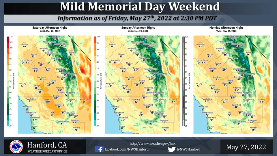
Mariposa Projected High Temperatures for Saturday through Monday: 71-73 Degrees
Oakhurst Projected High Temperatures for Saturday through Monday: 72-75 Degrees
Yosemite Valley Projected High Temperatures for Saturday through Monday: 71-73 Degrees
May 28, 2022 - The National Weather Service Hanford Office reports high temperatures across Central California will be a few to several degrees below normal throughout the Memorial Day weekend.
  Area Forecast Discussion...CORRECTED
  National Weather Service Hanford CA
  130 AM PDT Sat May 28 2022


  .SYNOPSIS...A cooling trend will continue for the Memorial Day
  weekend with below average temperatures expected across the
  central California interior. Strong winds are expected until at
  least Sunday evening for the Kern County desert and adjacent
  slopes. Temperatures will once again return to above average
  by the middle of next week with dry weather for the foreseeable
  future.

  &&

  .DISCUSSION...The cooldown has begun, and expect cooler air to
  continue to flow into the region over the remainder of the holiday
  weekend. Friday`s highs were considerably lower, with daytime
  highs in the mid to upper 80`s throughout the San Joaquin Valley.
  However, most locations in the Kern County desert remained above
  90 degrees. With cooler temperatures, comes gusty winds for at
  least some portion of our forecast area, especially this time of
  year. Winds have already picked up along the Mojave Desert slopes,
  with a few spots reporting gusts around 50 mph. Gusty westerly
  winds, with gusts mainly around 45 to 55 mph, will likely affect
  the prone areas of eastern Kern County until Sunday evening, so a
  Wind Advisory was issued for the Mojave Desert Slopes and the
  remaining desert zones. Winds will most likely pick up on the
  desert floor later this morning, so a Wind Advisory will be in
  effect for these areas beginning at 11 AM.

  The cooler than average temperatures will continue until Memorial
  Day, as a trough pattern persists over the Western U.S. It does
  not appear we will get much moisture from this system, although
  some cloud buildups will occur over the mountains in the
  afternoons. The warmest areas will reach into the 80`s for today
  through Memorial Day, and Sunday is projected to be the coolest
  day of this period. Blended guidance indicates highs could fall
  below 80 degrees in the San Joaquin Valley on Sunday, with a 30 to
  40 percent probability.

  Tuesday will be a bit warmer as a ridge of high pressure moves
  closer to the CA coast. This ridge will pass over the region
  on Wednesday, though will be a progressive pattern, as southwest
  flow aloft sets up along the coast by Thursday. By midweek,
  temperatures quickly trend back up, just in time for June. Highs
  on both Wednesday and Thursday have a good chance (35 to 50
  percent probability) of reaching at least 95 degrees (or about 5
  to 8 degrees above normal) in many locations in the Central Valley
  and Kern County desert. Triple digit heat is unlikely for our
  portion of Central California, but cannot be ruled out for some
  locations in the Kern County desert on Thursday (up to 25 percent
  chance, though mainly towards China Lake). Ensemble guidance
  shows decent agreement regarding this ridge pattern, including
  timing and strength.

  For Friday and next Saturday, mainly seasonal temperatures are in
  the forecast, as flow aloft transitions to a zonal pattern.
  For late next week into next weekend, temperatures may not be as
  cool as during this weekend, though some increased winds are
  possible in the typical prone areas in eastern Kern County and the
  West Side Hills. Dry weather will continue through the period.

  &&


  .AVIATION...VFR conditions will prevail throughout the Central
  California interior for at least the next 24 hours. Local surface
  wind gusts reaching 35 to 45 knots will be possible across the
  eastern slopes of the Kern County mountains and much of the Kern
  County desert after 18Z Saturday.

  &&

  .AIR QUALITY ISSUES...
  None.
Source: NWS

