


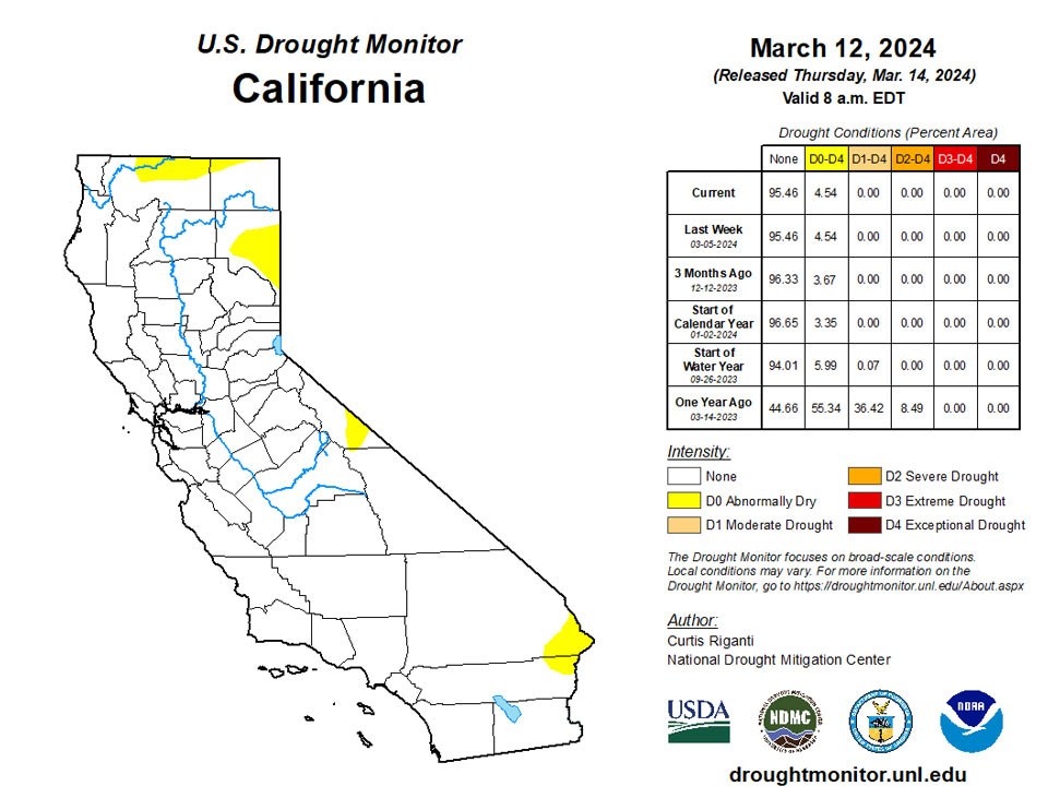
California and National Drought Summary for March 12, 2024
Summary
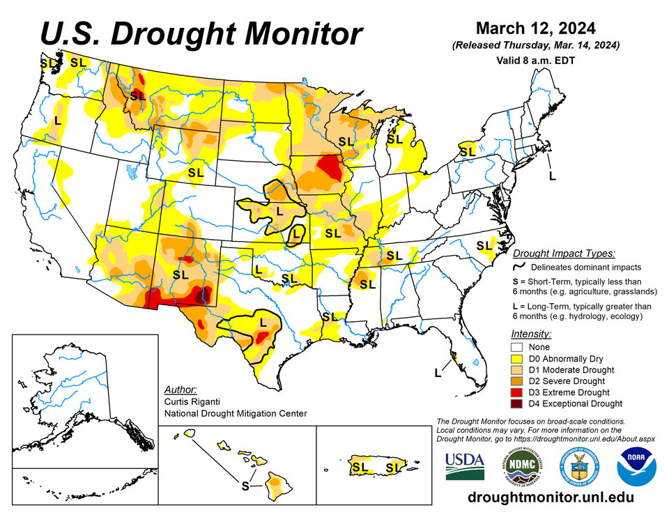
March 14, 2024 - Moderate to heavy rain amounts fell across parts of the Southeast and Northeast this week, leading to localized improvements to ongoing drought and abnormal dryness in the Southeast, and mostly unchanged conditions in the Northeast, aside from western New York, which missed out on the heavier precipitation and saw minor degradations. The central third of the contiguous U.S. saw a mix of improvements and degradations, based on where heavier precipitation did or did not fall and where dry and windy conditions continued. Parts of Illinois, Indiana, Ohio, the Michigan Lower Peninsula, southern Missouri and southeast Kansas saw improving conditions after heavier rains fell there. Meanwhile, moderate drought expanded in northwest Missouri and portions of west-central Wisconsin, Minnesota, northwest Iowa, the far southern Michigan Upper Peninsula and far northeast Wisconsin. Much of Texas remained the same, with a few degradations in the southeast corner and several degradations in central and southern Texas where long-term drought conditions are still causing impacts. Recent dryness and warm and windy weather in northwest Oklahoma and the Texas and Oklahoma panhandles led to abnormal dryness developing there. Short-term dryness and high evaporative demand led to large areas of degrading conditions in northeast Wyoming, while west-central Wyoming, north-central Colorado, northeast Utah, western Montana, and the northern Idaho Panhandle all saw areas of improvement due to lower evaporative demand and improving snowpack recently. In Hawaii, an active trade wind pattern continued, leading to some improvements on the windward (northeast) slopes of the Big Island and Kauai, while a small area of moderate drought developed on the leeward (southwest) portion of Kauai. In Puerto Rico, a few improvements were made where recent rainfall has improved streamflows and crop stress, and lessened rainfall deficits and raised reservoir levels. No changes were made to the Drought Monitor this week in Alaska.
Northeast
Moderate to heavy precipitation fell across most of the Northeast this week, excluding parts of western New York and a few other areas. Temperatures across the region were warmer than normal, with departures in western Pennsylvania and western New York 15-20 degrees above normal in many spots. In western New York, decreasing streamflows and soil moisture and increasing short-term precipitation deficits led to small growth of abnormal dryness and moderate drought areas where long-term drought conditions were already present. The depiction was also changed to an “SL” label, reflecting that dryness there is both short- and long-term. In northwest Pennsylvania and southwest New York, recent precipitation has improved conditions enough to lead to the removal of abnormal dryness there. Despite recent precipitation, moderate long-term drought continued this week on Nantucket, where in contrast to Martha’s Vineyard, groundwater deficits remained significant. The rest of the region remained free of drought or abnormal dryness this week.
Southeast
Above-normal temperatures, and generally wet weather, occurred across much of the Southeast region this week. Rain amounts in parts of Georgia and Alabama ranged from 2 inches to locally over 5 inches. Short-term precipitation deficits improved enough in eastern North Carolina for widespread improvements to ongoing abnormal dryness and moderate drought there. Abnormal dryness retreated in northern Alabama, southwest Alabama and the western Florida Panhandle after rain this week alleviated short-term precipitation deficits. Elsewhere, the region remained mostly free of drought or abnormal dryness, aside from lingering areas in eastern North Carolina, far northern Alabama, southwest Alabama and the Tampa Bay area, where long-term drought continued.
South
Rainfall amounts this week in the South region varied widely. In western Oklahoma, south Texas, and the Oklahoma and Texas Panhandles, the weather this week was mostly dry. In north-central Texas, portions of Louisiana and Arkansas, central and southern Mississippi, and south-central Tennessee, rainfall accumulations of 1-2 inches occurred, with locally higher amounts. Much of the central and eastern part of the region saw above-normal temperatures, with readings commonly falling into the 2-8 degrees above normal window. In western Texas and the Oklahoma Panhandle, temperatures were generally closer to normal, with most readings falling somewhere between 4 degrees cooler than normal and 4 degrees warmer than normal. In south-central and southeast Tennessee, recent rainfall improved streamflows and precipitation deficits enough to result in improvements. Farther west in west-central and northwest Tennessee and adjacent east-central Arkansas, abnormally dry conditions expanded where short-term precipitation deficits paired with high evaporative demand and lowering streamflow. In areas of recent heavy rainfall in Louisiana, precipitation deficits lessened and soil moisture profiles improved enough for improvements in areas of abnormal dryness and moderate drought. In southeast Texas and nearby southwest Louisiana, abnormal dryness expanded and moderate drought developed where recent dryness and high evaporative demand combined with decreasing soil moisture and streamflow numbers. In central Texas, recent localized dryness occurred on top of long-term dryness and drought, which combined with very low streamflow in many locations to lead to expansion of drought and abnormal dryness areas. In the northeast Texas Panhandle and adjacent Oklahoma Panhandle and northwest Oklahoma, dry weather over the last couple of months combined with high evaporative demand led to the development of abnormal dryness. In these areas, wildfires have been common recently
Midwest
Warmer-than-normal temperatures occurred across the entire Midwest region over the past week. Compared to normal, the warmest areas were in Iowa, Minnesota, Wisconsin and Michigan, where temperatures mostly ranged from 4-12 degrees above normal, with locally warmer readings. Locally heavy rain (over 2 inches in some locations) fell in central and southwest Missouri, while rain also occurred in Illinois, Indiana, Ohio and the Lower Peninsula of Michigan. A few areas of precipitation occurred in Iowa and southern Wisconsin, but northern Iowa, central and northern Wisconsin, Minnesota and the Upper Peninsula of Michigan were mostly dry this week. In central and southwest Missouri, streamflow and short-term precipitation deficits improved enough for some improvements to ongoing moderate and severe drought and abnormal dryness. In northwest Missouri, where precipitation was mostly absent this week, continued dry, warm and windy weather combined with lowering soil moisture and streamflow led to expansions of moderate drought. Similar conditions in southwest Kentucky led to a small expansion of abnormal dryness, consistent with the one made in northwest Tennessee. In Illinois, Indiana, Ohio, far southeast Wisconsin and the Lower Peninsula of Michigan, localized heavier precipitation in the last few weeks led to improving short-term precipitation deficits and streamflow. Therefore, abnormal dryness coverage dropped this week in some of these areas. Low snowpack, decreasing soil moisture and dry and warm weather from the last couple months led to expansions in moderate drought in west-central Wisconsin; northeast Wisconsin and the southern Michigan Upper Peninsula; northeast, south-central and southwest Minnesota; and northwest Iowa.
High Plains
Eastern parts of the High Plains region were mostly warmer than normal this week, with temperatures 8-10 degrees above normal occurring in the eastern Dakotas. Colder-than-normal weather occurred in western Wyoming and parts of Colorado. Localized heavy rains from severe thunderstorms this week occurred in parts of central and southeast Kansas, leading to localized improvements to ongoing drought and abnormal dryness. In south-central and southwest Kansas, abnormal dryness developed where dry weather from the past couple of months combined with warm and windy conditions, similar to those experienced in northwest Oklahoma and parts of the Texas and Oklahoma panhandles. In southwest Nebraska, localized improvements were made to an area of abnormal dryness after a major snowstorm struck the area. Recent dry, warm and windy weather led to a small expansion of abnormal dryness in northeast Nebraska and far southeast South Dakota. In northeast Wyoming and adjacent southwest South Dakota, recent dry, warm and windy weather led to expansions of abnormal dryness and moderate and severe drought. Recent snowpack improvements in the Wyoming Range of west-central Wyoming and in the Never Summer and Medicine Bow Mountains of northern Colorado led to improvements to ongoing abnormal dryness in both areas.
West
Temperatures across the West this week were primarily near normal or colder than normal. Compared to normal, the coldest area was southern Idaho, where temperatures mainly ranged from 6-12 degrees below normal. Portions of central and southeast Montana were 3-6 degrees above normal. Heavy precipitation fell in parts of north-central and northwest California, and along the Oregon and Washington coasts. Elsewhere, precipitation also fell in some of the mountainous parts of the northern half of the West region. After recent heavy precipitation in western Oregon and improvements to streamflow and long-term precipitation deficits, an area of abnormal dryness was removed from west-central Oregon. Given recent wetness, further improvements in the area may occur in coming weeks. In western Montana and northern Idaho, recently improved snowpack and lessening precipitation deficits led to several improvements to ongoing drought and abnormally dry conditions. Due to low evaporative demand and improved long-term precipitation deficits, northeast Utah saw reduced coverage of abnormal dryness this week.
Caribbean
Recent rainfall has improved short-term precipitation deficits, streamflow and crop stress in a few areas of west-central and eastern Puerto Rico. As a result, abnormal dryness was reduced in coverage on the western and eastern halves of Puerto Rico. Temperatures this week were above normal, mostly ranging from 1-3 degrees warmer than normal.
This was a drier week for parts of the U.S. Virgin Islands, where precipitation amounted to 0.65 inches on the west end of St. Thomas, while the eastern part of the island was left fairly dry, according to local observers. St. Croix observers reported 0.19 inches to 0.89 inches on the west end, and lighter amounts to the east. Rainfall for St. John was virtually nonexistent.
In terms of drought, St. Thomas remained abnormally dry in the long term, while St. Croix and St. John were free of dryness. Rainfall has been above normal for St. Croix in the past month, while St. John received 5.66 inches at Windswept Beach in February, which is a record for that location. March, however, has been rather dry for St. John.
The Standardized Precipitation Index indicated neutral or wet conditions at all time scales for St. John. The same was true for East Hill on St. Croix, except at the 12-month SPI, which indicated mild dryness. Missing precipitation data for St. Thomas prevented the calculation of SPIs for that island.
Well levels on all three islands have responded positively to precipitation within the past two weeks. The Vegetation Health Index for all islands showed good conditions on all islands.
Pacific
Above-normal precipitation fell in parts of southeast Alaska this week, while the rest of the state was mostly drier than normal. Temperatures in southeast and south-central Alaska were mostly within 5 degrees of normal. Elsewhere, temperatures were mainly 5-15 degrees colder than normal, except for the North Slope, where temperatures ranged from 10-25 degrees colder than normal. Alaska remained free of drought or abnormal dryness this week.
An active trade wind pattern continued this week, leading to wet weather on the windward (northeast facing) slopes of the islands, while the leeward (southwest facing) slopes generally had drier weather. Temperatures in Hawaii were mostly within 2-3 degrees of normal. On the Big Island, the trade wind rainfall pattern led to some improvements to ongoing drought and abnormal dryness in northern portions of the island. On Kauai, abnormal dryness coverage was reduced in the southeast, while a small area of short-term moderate drought developed in the southwest portion of the island, which saw drier weather again this week. No other changes were made in Hawaii this week.
Precipitation was low for the Republic of Palau, with Koror and Palau IAP receiving 0.45 inches and 0.62 inches, respectively, but abundant rainfall the previous week should leave water supplies adequate.
The Mariana Islands all remained in drought with Guam in severe drought (D2-S), Rota in moderate drought (D1-S), and Saipan at D2-S. Guam received 0.44 inches, while Rota reported 0.38 inches. Saipan received 0.41 inches or less at the three reporting locations. These islands need an inch weekly to meet minimum water needs.
The Federated States of Micronesia were largely quite dry. President Wesley Simina declared a national emergency due to severe drought, which is expected to worsen in coming months, as reported by Radio New Zealand. For some of the Outer Islands, rain catchment systems and rivers were running dry, leaving the water supply depleted and compromising sanitation and public health. People in the affected communities desperately need food and water. The states of Yap, Pohnpei and Chuuk declared an emergency according to their respective state laws.
Kapingamarangi reported 4.66 inches. Nukuoro got 2.57 inches and returned to normal condition after being abnormally dry (D0-S) for the past three weeks. All other FSM locations received less than half an inch of rain. Chuuk Lagoon, Lukunor, and Pohnpei are abnormally dry (D0) on a short time scale. Woleai is in D1-S and received 0.10 inches for the week. Pingelap, Ulithi, and Yap are at D2-S.
The Marshall Islands all were dry, receiving 0.51 inches or less for the week. Majuro, previously at D0-S, entered D1-S as the location went two weeks without rainfall. All households that rely on rain harvesting and are not connected to city water are out of water and must depend on water delivery from the city reservoirs. As of March 7, Majuro reservoirs were at 23.55 million gallons.
Kwajalein and Wotje remained at D2-S, and got virtually no rain. Jaluit continued at D0-S and reported 0.51 inches.
American Samoa remained free of dryness. Pago Pago, Siufaga Ridge and Toa Ridge received more than 2 inches of rain, which is the amount these islands need to meet minimum water needs.
Looking Ahead
According to forecasts from the National Weather Service Weather Prediction Center, heavy snowfall is forecast in the Colorado Front Range area near the beginning of the forecast period (March 14-15), while heavy precipitation with this storm system is also likely across other parts of the Four Corners states. Aside from portions of the Four Corners states, much of the West is likely to stay dry through Monday evening. Farther east, through Monday evening, half an inch (or more) of precipitation is forecast from central Nebraska eastward into parts of the Rust Belt. Rainfall amounts of a half inch to 2 inches, with locally higher amounts, is also forecast from central Texas eastward through southeast Oklahoma, Arkansas and southeast Missouri to most of Georgia and Tennessee and southern Kentucky.
The National Weather Service Climate Prediction Center 6-10 day forecast favors near-normal precipitation or above-normal precipitation across the contiguous U.S., covering the period from March 19-23. The highest confidence areas for above-normal precipitation are the Florida Peninsula, along the Gulf Coast, and from the Arizona/New Mexico border northward through Montana. Warmer-than-normal temperatures are favored across parts of the West, especially in Utah, Nevada, California, Idaho, Washington and Oregon, and in parts of the central and southern Great Plains. Below-normal temperatures are favored in the Southeast, excluding the southern Florida Peninsula where near- or above-normal temperatures are favored. Below-normal temperatures are also favored from central Montana eastward through North Dakota and northern South Dakota, Minnesota, Wisconsin and Michigan, with below-normal temperatures slightly favored in the Ohio River Valley and Rust Belt.
In Hawaii, cooler-than-normal temperatures are favored. Below-normal precipitation is likely on all islands except for the Big Island, where near-normal precipitation is favored. Warmer-than-normal weather is favored in Alaska, especially in the western reaches of the state. Wetter-than-normal weather is favored for central, northern and western Alaska, while drier-than-normal weather is favored in southeast Alaska.
Author(s):
Curtis Riganti, National Drought Mitigation Center
Denise Gutzmer, National Drought Mitigation Center
Dryness Categories
D0 Abnormally Dry—used for areas showing dryness but not yet in drought, or for areas recovering from drought.
Drought Intensity Categories
D1 Moderate Drought
D2 Severe Drought
D3 Extreme Drought
D4 Exceptional Drought
Drought or Dryness Types
S Short-term, typically less than 6 months (agriculture, grasslands)
L Long-term, typically more than 6 months (hydrology, ecology)
SL Area contains both short- and long-term impacts
Source: National Drought Mitigation Center

