


California and National Drought Summary for March 26, 2024
Summary
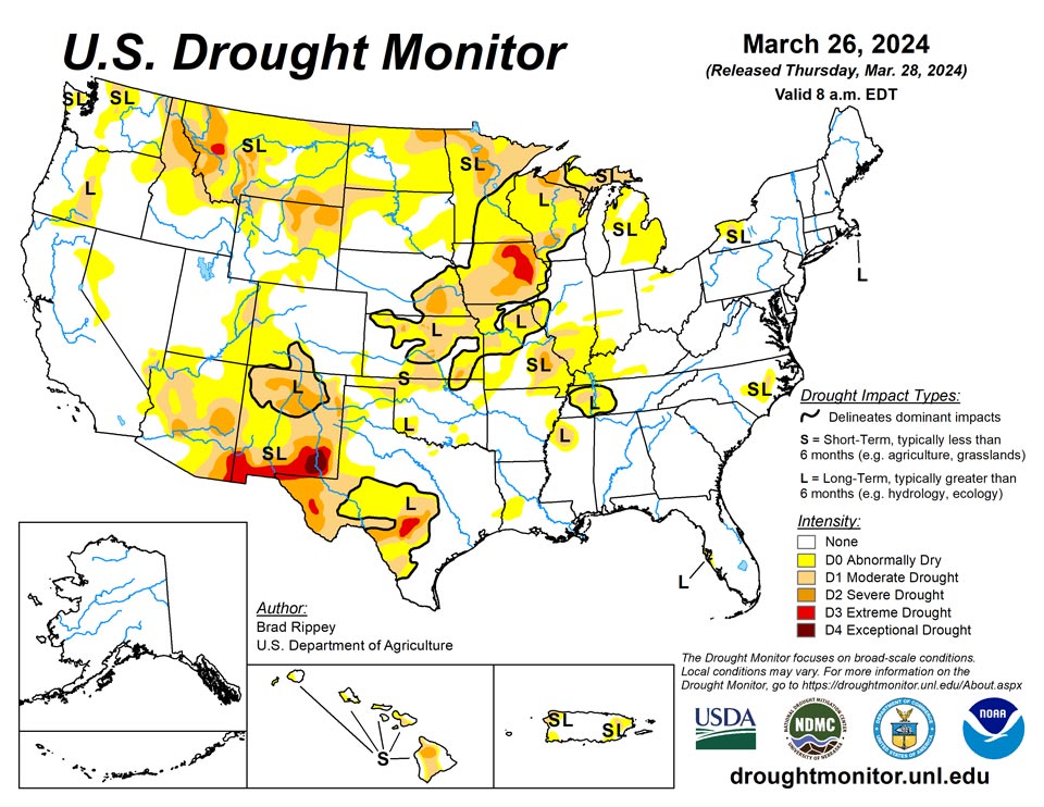
March 28, 2024 - A winter-like storm system crossing the central Plains and upper Midwest resulted in a variety of weather hazards, including blizzard conditions, high winds, heavy rain, and locally severe thunderstorms. That storm was preceded by a weaker system, which produced a stripe of snow from northern Montana into portions of the Great Lakes States. Combined, the two storms produced 40 to 50% of the season-to-date snowfall in 4 to 5 days at several upper Midwestern locations, including Eau Claire, Wisconsin, and Minneapolis-St. Paul, Minnesota. Though the winter-like storm eventually weakened and drifted northward into Canada, impacts lingered. For example, the wettest day ever observed during March was noted on the 23rd in mid-Atlantic locations such as Philadelphia, Pennsylvania, and New York’s LaGuardia and JFK Airports. Elsewhere, the West received widespread but generally light precipitation.
Northeast
There were no changes to the Northeastern depiction. Moderate drought (D1) was limited to portions of five counties in western New York and Nantucket Island in Massachusetts. In the latter location, ongoing groundwater concerns have led to the D1 designation. On March 20, fast-moving wildfires in West Virginia were unrelated to drought, instead fueled by wind gusts above 60 mph, low humidity levels, and ample fine fuels. The largest individual blaze in West Virginia was the 4,909-acre Waites Run Fire, which mostly burned in Hardy County.
Southeast
Chilly Southeastern conditions yielded to showery weather. On March 19, as the drought-monitoring period began, Alabama locations such as Anniston and Tuscaloosa posted daily-record lows of 28°F. By March 20, during a brief period of dry, windy weather, wildfires flared in western Virginia and environs. A wind gust to 61 mph was clocked on that date in Front Royal, Virginia. The largest individual wildfire in Virginia was the 6,321-acre Waterfall Mountain/Shenandoah Forest/211 Fire, west of Luray. Later, heavy rain clipped eastern North Carolina’s patch of abnormal dryness (D0) and moderate drought (D1), resulting in a slight reduction in coverage.
South
Additional heavy showers further trimmed coverage of abnormal dryness (D0) and moderate to severe drought (D1 to D2) in the mid-South and western Gulf Coast region. In fact, severe drought (D2) was eliminated from Mississippi, while moderate drought (D1) was eradicated from Louisiana. Farther west, however, there was modest expansion of dryness and drought in northern and western sections of Oklahoma and Texas. On March 24, high winds raised dust in western Texas, where Lubbock clocked a southwesterly wind gust to 73 mph and reported visibilities as low as 2 miles. On March 24, according to the U.S. Department of Agriculture, topsoil moisture was rated 44% very short to short in Texas, along with 27% in Oklahoma. On the same date, 51% of the winter wheat in Texas was rated in good to excellent condition, along with 70% of the crop in Oklahoma.
Midwest
Heavy precipitation—rain and snow—brought some dramatic drought changes to the Midwest. The highest totals, 2 to 3 inches or more, bisected Missouri and covered portions of Iowa, Minnesota, and Wisconsin. Where heavier precipitation fell but long-term issues such as groundwater shortages remained, the drought designation was changed from “SL” – both long- and short-term drought – to “L”. From March 21-24, snowfall totaled 14.3 inches in Eau Claire, Wisconsin, and 11.3 inches in Minneapolis-St. Paul, Minnesota. Through March 20, season-to-date snowfall had totaled just 16.4 inches (34% of normal) in Eau Claire and 14.3 inches (31%) in Minneapolis-St. Paul. A large percentage of the Midwestern spring snow fell on March 24, when daily-record totals included 10.0 inches in Eau Claire and 8.2 inches in Minneapolis-St. Paul. However, precipitation bypassed a few Midwestern areas, with those areas noting some slight expansion of abnormally dry conditions (D0) and moderate drought (D1). On March 24, with precipitation underway, the U.S. Department of Agriculture indicated that statewide topsoil moisture was rated more than 40% very short to short on March 24 in several Midwestern States, including Illinois (44%) and Missouri (42%).
High Plains
While much of the region experienced precipitation, including late-season snow, there were some targeted areas of expansion of abnormal dryness (D0) and moderate drought (D1), especially in southern Kansas. General reductions in the coverage of D0 and moderate to severe drought (D1 to D2) were observed in several areas, including parts of the Dakotas, northern Kansas, and eastern sections of Montana and Nebraska. According to the U.S. Department of Agriculture, topsoil was rated more than 40% very short to short on March 24 in Wyoming (55%), North Dakota (49%), South Dakota (47%), Nebraska (47%), Kansas (45%).
West
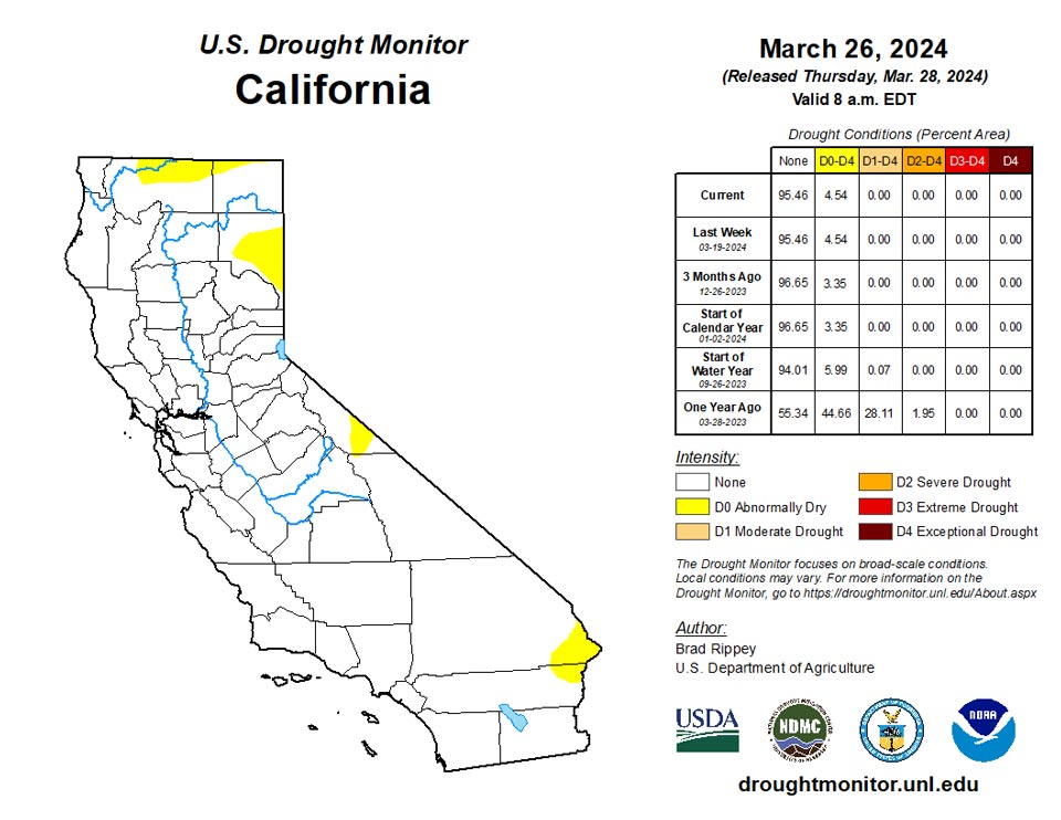
Drought changes were mostly minor, although a reassessment of season-to-date precipitation and conditions led to some drought improvement being depicted in parts of New Mexico. Approaching the traditional Western peak snowpack date of April 1, snow-water equivalencies were mostly near or above average, except in much of Montana, Washington, northern Idaho, and northeastern Wyoming. Those low snowpack numbers were reflected in ongoing moderate to extreme drought (D1 to D3) in the northern Rockies and environs.
Caribbean
In Puerto Rico, rainfall continued to provide targeted relief from abnormal dryness (D0) and moderate drought (D1), which has had a diminishing footprint in recent weeks.
The weather over the U.S. Virgin Islands (USVI) during this U.S. Drought Monitor (USDM) week (March 20-26) was basically hot and dry. Scattered showers dropped up to a fourth of an inch of rain on parts of St. Croix, but most locations in the USVI reported less than a tenth of an inch of rain, if any. According to USGS well data, groundwater levels steadily fell this week on all 3 islands, however satellite observations of vegetative health (VHI) did not show any vegetative stress. March month-to-date precipitation totals were below normal, but rain earlier in the month and wet weather in February held conditions at status quo this week, so long-term abnormal dryness (D0-L) continued on St. Thomas while St. John and St. Croix remained free of drought and abnormal dryness.
Pacific
Alaska remained completely free of dryness and drought. Mild weather returned across mainland Alaska, while some western locations reported stormy conditions. In western Alaska, daily-record precipitation totals included 0.34 inch (on March 19) in Nome and 0.92 inch (on March 21) in Cold Bay. With highs of 50 and 51°F, respectively, on March 22 and 24, Fairbanks posted its first 50-degree readings since September 30, 2023.
For the second week in a row, there were no changes to the drought depiction in Hawaii, with moderate to severe drought (D1 to D2) covering 32% of the state. Despite a recent drying trend in windward areas of the Big Island, Hilo’s March 1-26 rainfall totaled 14.99 inches (140 percent of normal). At the state’s other major airport observation sites, March 1-26 rainfall ranged from 0.23 inch (11 percent of normal) in Honolulu, Oahu, to 0.93 inch (41 percent) in Kahului, Maui.
In the U.S.-Affiliated Pacific Islands (USAPI), a dry trade-wind pattern dominated Micronesia (Micronesia is the part of the USAPI that is located north of the equator) during this U.S. Drought Monitor (USDM) week (March 20-26). Weak tropical disturbances moving through a near-equatorial trough (NET) brought rain to parts of Micronesia, while a cold front moved through the Marianas. (By the time fronts reach the USAPI, they deteriorate into shear lines, but they can still generate areas of rain.) The trade-wind pattern dominated over most of the islands, so weekly rainfall totals were below the weekly minimum required to meet most water needs (which is 1 inch for the Marianas and American Samoa and 2 inches elsewhere), except in eastern parts of the Federated States of Micronesia (FSM) and adjacent Marshall Islands (RMI) where they were above. A ridge of high pressure kept the weather mostly dry across American Samoa (which is the part of the USAPI that is located south of the equator), although unstable air moved into the region near the end of the USDM week.
About an inch of rain (1.15 inches) fell at Airai in the Republic of Palau, which is half of the weekly minimum needed to meet most water needs. This week marked the third consecutive dry week, which is a trigger for the initiation of abnormal dryness. Water levels at the Ngerimel and Ngerikiil reservoirs, Airai, have significantly dropped due to insufficient rainfall and heightened water consumption, prompting the issuance of a Water Shortage Watch, and reports of vegetation yellowing were also received recently. D0-S was added to Palau.
Drought is stressing vegetation such as coconuts, in addition to causing water shortages, in Yap State. In eastern Yap State, the people of Satawal Island reported a dire and critical emergency situation of water catchments running dry. Limited showers the last few days have refilled some of the water tanks to half or a quarter full. Well water may be unsafe to use; people who have been using well water for drinking and cooking were becoming ill. Water in catchment tanks on Satawal, Ifaluk, and Eauripik can last from 1 to 3 weeks, depending on island, if no more rain falls. About half of an inch of rain (0.62 inch) has been recorded at the main National Weather Service (NWS) weather station on Yap island for March 1-26, giving this month a rank of second driest out of 73 years, so far. With 5 consecutive dry months, 11 of the last 12 weeks dry, and a near-record dry March, the status at Yap was worsened to D3-S (extreme drought).
March 18 and March 25 statements discussed a Drought and Inundation Response Plan by the RMI government. The report estimated that 3,970 people in northern and western RMI were affected by the drought, with a total of 18 atolls/islands reporting water scarcity in their respective locations. Many islands have no water for people, livestock, and vegetation. The report warned that, even if rain were to begin by the end of April or early May, the impacts of the drought will continue for several months – it will take many months for water sources to be replenished, water quality to improve, and crops to be planted and harvested. A declaration of a State of Emergency for drought in the RMI was recommended. Only an inch of rain (0.99 inch) has fallen so far this month at Majuro, with March 1-26, 2024 ranking as the sixth driest such March period out of 70 years of data. With the last 7 consecutive weeks dry, and the last 4 months dry, the status at Majuro was worsened to D2-S (severe drought). No rain has fallen at Wotje since February 15; only 2 other years have had no rain for February 16-March 26. With 10 of the last 11 months dry, and no rain at all falling for the last 5 weeks, the status at Wotje was worsened to D3-SL (short- and long-term extreme drought).
Some level of drought or abnormal dryness continues at the other USAPI stations. In the RMI, D0-S continues at Ailinglaplap and Jaluit, and D1-S continues at Kwajalein. In the FSM, D1-S continues at Chuuk, Pingelap, and Woleia, while D2-S continues at Ulithi. In the Marianas, D1-S continues at Rota and D2-S continues at Guam and Saipan. Satellite observations show some stressed vegetation on Guam. Fire Weather Watches and Red Flag Warnings were issued for Guam and wildfires developed in very dry and windy conditions.
Elsewhere in the FSM, last week was wet and March is wet (above monthly minimums), so D-Nothing (no drought or abnormal dryness) continued at Pohnpei, Kosrae, Lukunor, Kapingamarangi, and Nukuoro. Previous weeks were wet and March is wet in American Samoa where D-Nothing continues.
Looking Ahead
Rain will linger along the Atlantic Coast through Thursday, with parts of interior New England experiencing a rain-to-snow transition on Friday. Farther west, Pacific storminess will initially affect the northern half of the western U.S. By Friday, however, the focus for stormy weather will shift into California. During the weekend, precipitation will spread farther inland across the Great Basin, Intermountain West, and parts of the Southwest. Early next week, precipitation will return across the nation’s mid-section, initially extending eastward from Colorado and Wyoming.
The NWS 6- to 10-day outlook for April 2 – 6 calls for the likelihood of near- or below-normal temperatures nationwide, except for warmer-than-normal weather in California, the Great Basin, northern New England, and southern Florida. Meanwhile, near- or above-normal precipitation across much of the country should contrast with drier-than-normal conditions in coastal sections of Oregon and northern California, as well as a broad area covering much of the eastern Plains, mid-South, and Midwest.
Author(s):
Brad Rippey, U.S. Department of Agriculture
Richard Heim, NOAA/NCEI
Dryness Categories
D0 Abnormally Dry—used for areas showing dryness but not yet in drought, or for areas recovering from drought.
Drought Intensity Categories
D1 Moderate Drought
D2 Severe Drought
D3 Extreme Drought
D4 Exceptional Drought
Drought or Dryness Types
S Short-term, typically less than 6 months (agriculture, grasslands)
L Long-term, typically more than 6 months (hydrology, ecology)
SL Area contains both short- and long-term impacts
Source: National Drought Mitigation Center

