


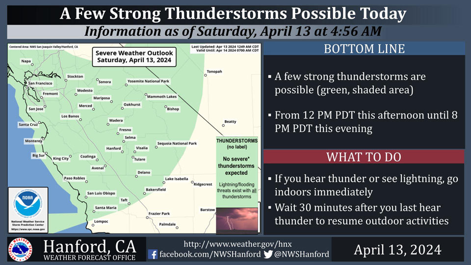
Possible Thunderstorms in Mariposa, Madera, Merced, Fresno, and Tuolumne Counties and Yosemite National Park
April 13, 2024 - National Weather Service Hanford Office officials report a few strong thunderstorms are possible from 12 PM PDT this afternoon until 8 PM PDT this evening.
Small hail and wind gusts near 45 miles per hour are a couple of hazards associated with thunderstorms.
In addition to dangerous cloud to ground lightning strikes, any thunderstorm can produce intense rainfall rates, leading to localized flooding.
Area Forecast Discussion
National Weather Service Hanford CA
300 AM PDT Sat Apr 13 2024
.KEY MESSAGES...
1. A steep drop in temperatures this weekend before rebounding
next week.
2. A disturbance will move through Central California this
weekend, resulting in cooler temperatures, a chance for rain in
the San Joaquin Valley, and snow above 6,000 feet in the Sierra
Nevada and Kern County Mountains.
3. A few strong thunderstorms may develop this afternoon and
evening.
4. Strong wind potential continues today across the ridge tops
of Central California.
&&
.DISCUSSION...
Upper level disturbance continues its approach toward the West
Coast this morning. Satellite imagery shows the center some 200
miles west of the Bay Area as subtropical moisture is wrapping
around the low. While satellite water vapor (precip-water)
analysis indicates the presents of Atmospheric River moisture,
the intensity of the moisture to light to moderate categories
upon arrival. In the meanwhile, regional Doppler radar shows the
precipitation making landfall this morning and quickly
approaching Central California. Ensemble onset of precipitation
indicates an arrival time of 7 to 9 AM PDT across the north end
of the district (Merced-Mariposa Co.) and spreading south during
the day. Current 24 hour temperature change charts show the
area down by 4 to 8 degrees. Therefore, expecting temperatures
to struggle to reach 80 degrees as 60s and 70s will be more
common. In addition, surface wind analysis shows the
continuation of breezy conditions ahead of the cold front over
Central California. Will expect widespread precipitation today
with afternoon thunderstorms. Sunday will remain similar to this
Saturday with a return to drier conditions by Monday and into
the mid-week period.
High-Res Short-range ensemble upper-air analysis favoring the
morning timing solution of the upper low reaching Central
California. At that time, Integrated Water Vapor Transport
analysis show a possible very weak Atmospheric River reaching
into Central California and increase the potential for heavy
precipitation. Currently, Winter-Like Weather Advisories have
been issued for locations mostly above 6,000 feet where 6 inches
and above of snow will be observed. The Kern County Mountains
were also included in the advisories where a few inches of snow
will impact the area. Areas above 6,000 feet have a Probability
of Exceedance (PoE) of receiving 6 inches of snow remain in the
60 to 90 percent range. Areas just below 6,000 feet fall in the
PoE range of 40 to 50 percent (which is still good for
significant snow). While 6 inches is unlikely closer to 3,000
feet, PoE for 1 to 2 inches is still in the range of 40 to 50
percent. Based on ensemble upper level temperature analysis,
will monitor snow levels in case snow is able to reach Tejon
Pass.
Lingering light precipitation expected to continue to Sunday as
the upper low slowly crosses California. Yet, by Sunday, cold
and very stable air filters into the region as PoE of generating
convective activity diminishes to near zero percent. Ensemble
Cluster Analysis then shows a strong signal toward the passage
of the upper low into the Four-Corners area and away from
California. Cluster Analysis then points toward the development
of a ridge pattern going to mid-week. While the ridge pattern is
not very amplified, the ridge pattern will provide of some
warming. PoE of reaching the 75 degree mark across the valley
rises to near 80 percent by next Wednesday and Thursday. After
the weekend storm, Central California returns to dry and warm
for much of the week.
&&
.AVIATION...
Afternoon thunderstorms between 18Z today and 02Z Sunday for
the Sierra Nevada and adjacent foothills could result in
localized MVFR conditions. Rain in the San Joaquin Valley and
snow in the Sierra could cause MVFR conditions after 18Z today.
Otherwise, VFR conditions are expected across the Central
California interior for at least the next 24 hours.
&&
.AIR QUALITY ISSUES...
None.
&&
.CERTAINTY...
The level of certainty for days 1 and 2 is high.
The level of certainty for days 3 through 7 is medium.
Certainty levels include low...medium...and high. Please visit
www.weather.gov/hnx/certainty.html for additional information
and/or to provide feedback.
&&
.HNX WATCHES/WARNINGS/ADVISORIES...
Wind Advisory until 11 AM PDT this morning for CAZ300-308-313.
Winter Weather Advisory from 11 AM this morning to 11 PM PDT
this evening for CAZ323-325>331-333-334-336.
&&
Source: NWS

