


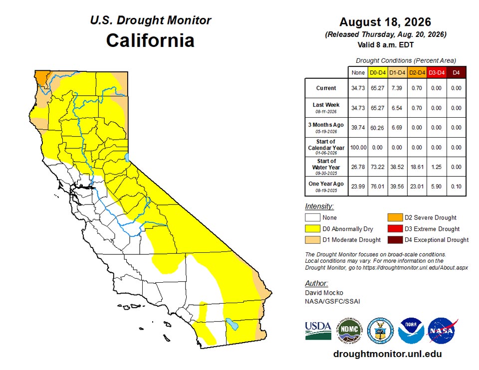
California and National Drought Summary for August 18, 2026
Summary
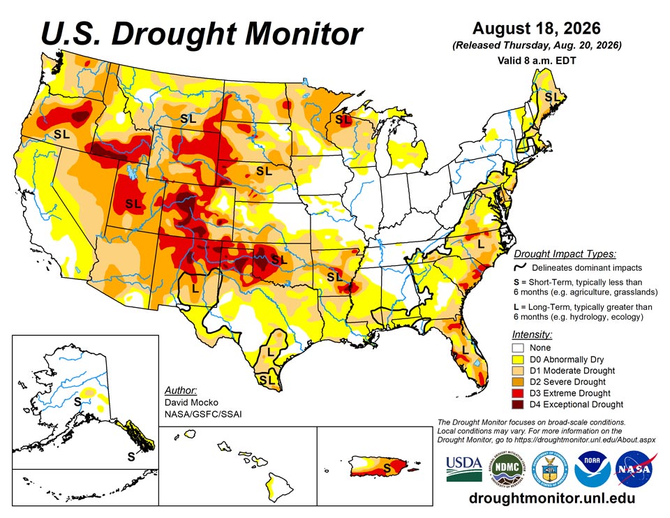
August 20, 2026 - The area with the highest rainfall amounts this past week was primarily a wide band from Nebraska east to Iowa, Illinois, Indiana, Ohio, and West Virginia. Totals over 5 inches were observed in central Illinois and Indiana, with some areas of east Indiana receiving over a foot of rain in the past week. These storms were tracking to the east on the north-side of a high pressure over the southern U.S. The northern Great Plains states also received 1 to 3 inches over wide areas, as did southeast Wyoming, eastern Colorado, and northwest Kansas. In the Southwest, monsoonal flow continued with scattered storms, providing rainfall amounts generally between 0.5 and 1.5 inches. The eastern seaboard from Maine to Florida received scattered but moderate rainfall. The high pressure over the southern U.S. suppressed precipitation over the southern Great Plains and lower Mississippi valley. There was also very limited precipitation in the west coastal states as well as in Michigan and most of Wisconsin.
Temperatures were particularly above normal in the southern Great Plains and lower Mississippi valley, with the warmest above normal area over Oklahoma. The west as well as the southeast were also a few degrees above normal. Rain and storms in the central states from Wyoming to Ohio kept temperatures in this region slightly below average. The northern Great Plains had the coldest below normal temperatures.
Northeast
Northern Maine, New Hampshire, and Vermont had limited rainfall in the past week, leading to degradations in drought. Deterioration of soil moisture and streamflow were noted in this area. Elsewhere, localized precipitation resulted in small improvement in drought conditions in upstate New York and in central and eastern Massachusetts. Similarly, Maryland, Pennsylvania, and West Virginia had some improvements where there was significant rain during the past week.
Southeast
Southern Alabama had wide areas of drought degradation in the southwest part of the state from the warm temperatures and lack of rainfall, shown by flash drought indicators among other metrics. Meanwhile, central Virginia and western North Carolina had drought improvement from the rainfall over the past week. The rest of North Carolina, South Carolina, Georgia, and Florida were mostly status quo for the past week, with only limited areas showing small drought improvements or degradations. There remain some areas of extreme drought in northern North Carolina, coastal South Carolina, and some areas in Florida.
South
Dryness and drought continued over this region for the past week. All states saw declining drought conditions. The high pressure over the South resulted in anomalously warm temperatures and almost no precipitation. Flash drought conditions had led to dry ponds and creeks and poor to very poor crop conditions in Texas, Louisiana, Arkansas, and Oklahoma. Drought also was degraded over much of southern Mississippi. The only area with drought improvement was eastern Tennessee, where there was significant rainfall. Extreme to exceptional drought conditions continue in western Oklahoma and the Texas Panhandle, as well as southeastern Arkansas.
Midwest
Widespread and heavy rainfall fell in an area from Iowa, Illinois, Indiana, Ohio, to eastern Kentucky. Eastern Kentucky had a two-category improvement from heavy rainfalls from the storm tracks. The rainfall led to removal of all abnormally dry areas in Indiana, Ohio, and Kentucky as well as most of Illinois. Iowa, Illinois, and northern Missouri had drought improvement, while southern Missouri had degradation from the warm temperatures and lack of rainfall. Further north, Michigan and Wisconsin had moderate areas of drought degradation with little to no rainfall in the past week. Minnesota had more scattered rainfall, resulting in small areas of both drought improvement and degradation. There is an area of extreme drought in northern Wisconsin.
High Plains
Southern Kansas had some drought degradations from the flash drought warm and dry conditions over the past week. However, eastern Colorado and Wyoming east through Nebraska and northern Kansas received welcome rainfall resulting in drought improvements in these areas. South Dakota was mostly status quo from the past week. North Dakota was mostly dry leading to degradation in drought. Two areas in the southwest and northwest of North Dakota received some rainfall and drought improvement. Extreme drought continues to be in place over western South Dakota and western Nebraska, extending into much of Wyoming and central/western Colorado. Exceptional drought locations are noted in western Nebraska and parts of Colorado.
West
The western states of California, Oregon, Washington, Nevada, and northern Utah generally received little rainfall. There were small to moderate areas in each of these locations with drought degradations. Southern Utah and Arizona experienced some monsoonal rainfall leading to small areas of drought improvement. Eastern New Mexico was warm and dry and had areas of drought degradation. Areas near the Idaho/Montana border as well as northeastern Montana received the most rainfall. Southeastern Montana received little rainfall resulting in a corresponding area of drought degradation. There are areas of extreme drought in Utah, southern Idaho, and in Oregon, with exceptional drought in northeastern Oregon and far southern Idaho.
Caribbean
Over Puerto Rico, continued dry conditions and record-low streamflow were observed. Water service restrictions have continued over some parts of the Commonwealth. Much of Puerto Rico had drought degradations from the previous week. Extreme drought covers the eastern part of Puerto Rico as well as in the southwestern part.
Short-term extreme drought continued across the U.S. Virgin Islands this week. Rainfall amounts were paltry in most areas, with up to 0.29 inches on St. John and up to 0.56 inches on St. Croix, with smaller amounts in most locations. Vegetation continued to struggle this week, and groundwater levels remained about the same or dropped amidst extremely low 1- and 3-month rain totals. While the current short-term drought, statistically, is not yet at exceptional drought level, conditions will be monitored for possible degradation moving forward if dry weather continues. In addition to adverse impacts to vegetation and well levels, widespread livestock casualties have also been reported.
Pacific
In Alaska, two areas in the eastern part of the state had abnormally dry areas introduced. Much of southeast Alaska in the panhandle continues to be dry, although there was rain in the far north of the panhandle, leading to some drought improvement.
In Hawaii, Hurricane Lana passed just south of the islands last weekend, with extremely heavy rainfall over much of the state, especially on the eastern side of the islands. Most of the abnormally dry areas were removed, with some areas remaining on the west side of the islands where rainfall totals were lower.
Little to no rain fell this week in American Samoa at Pago Pago, Siufaga Ridge and Toa Ridge. Moderate short-term drought developed, as less than 1 inch of rain has fallen four of the last five weeks at Pago Pago.
A dry week occurred in Palau following a few recent dry weeks with less than 1 inch of rain. Satellite imagery also suggested drying of vegetation in some areas, and short-term abnormal dryness developed.
The Mariana Islands remained free of drought or abnormal dryness this week. On Saipan, 0.63 inches of rain fell this week after 3.11 inches fell last week. On Tinian, the week was drier, with 0.18 inches of rain having been reported (with a couple days missing). However, 6.01 inches of rain fell there last week. On Rota, 3.1 inches of rain fell, continuing a recent wet spell there. On Guam, 0.67 inches of rain fell this week after 4.82 fell last week.
Utirik, Wotje, Majuro and Mili remained free of drought or abnormal dryness this week. Utirik reported 0.75 inches of rain this week after just 0.06 inches last week, but over 2 inches the week prior kept conditions from degrading to abnormal dryness this week. In Wotje, 1.95 inches of rain were reported this week. In Majuro, 3.76 inches of rain were reported, and in Mili, 5.79 inches of rain fell, marking two weeks in a row with at least 5 inches of rain. Kwajalein remained free of drought or abnormal dryness this week after 2.27 inches of rain fell. In Ailinglapalap, 1.73 inches of rain were reported, with one day missing, and conditions remained free of drought or abnormal dryness. In Jaluit, 1.68 inches of rain were reported, with one day missing, marking the third week in a row with less than 2 inches of rain, and short-term abnormal dryness developed.
Dry weather continued for another week in Yap, with no rain having been reported this week, marking the third week in a row with less than 1 inch of rain, and short-term abnormal dryness developed. In Ulithi, 0.21 inches of rain fell, marking the third consecutive week with less than 2 inches of rain. Conditions will be further monitored there, though the conditions are not yet abnormally dry. In Woleai, 0.33 inches of rain fell this week, marking the second week in a row with less than an inch of rain. In Chuuk, 10.12 inches of rain fell this week, over half of which fell on Aug. 18. In Lukunor, 5.94 inches of rain fell after a much drier preceding 2 weeks. In Nukuoro, 3.19 inches of rain fell this week after three weeks in a row with less than 2 inches. In Kapingamarangi, 1.57 inches of rain fell, marking two weeks in a row with less than 2 inches of rain. However, wet conditions prior to this have kept abnormal levels of dryness at bay. In Pohnpei, 8.14 inches of rain fell this week. In Kosrae, 13.76 inches of rain fell this week. No Drought Monitor depictions were made in Fananu or Pingelap, as no data were available for those locations.
Looking Ahead
Over the next five days leading up to next Tuesday, above-normal rainfall is possible east of the I-95 corridor along the Atlantic coast. Eastern Indiana, Ohio, and Pennsylvania could also be wet, as well as northern Minnesota and Wisconsin. The area where the Ohio River and Mississippi River meet is also forecast to receive above-normal rainfall. The Southeast should above-normal rainfall in many locations. The South should continue to have below-normal rainfall, with the Southwestern states having moderate monsoonal rains. The West Coast states are forecast to have little rainfall in the next five days.
The 6- to 10-day outlook (August 25-29, 2026) favors above-normal precipitation across the northern half of the Eastern Seaboard from South Caroline to the eastern Great Lakes region and into New England. Surplus precipitation is also favored throughout Hawaii and over most of mainland Alaska, except for the southern coast, southeast peninsula, and the Aleutian Islands. Below-normal rainfall is favored over much of Texas. Temperatures are likely to be well above-normal over much of the continental U.S. other than the far west coast and the eastern Great Lake to Mid-Atlantic. Hawaii is also favored to have above-normal warmth. Alaska is likely to be below-normal in the northwest part of the state and above-normal in the southeast part.
Author(s):
David Mocko, SSAI/NASA/GSFC
Curtis Riganti, National Drought Mitigation Center
Dryness Categories
D0 Abnormally Dry—used for areas showing dryness but not yet in drought, or for areas recovering from drought.
Drought Intensity Categories
D1 Moderate Drought
D2 Severe Drought
D3 Extreme Drought
D4 Exceptional Drought
Drought or Dryness Types
S Short-term, typically less than 6 months (agriculture, grasslands)
L Long-term, typically more than 6 months (hydrology, ecology)
SL Area contains both short- and long-term impacts
Source: National Drought Mitigation Center
