


October 8, 2026 - Yosemite National Park Dome Fire Thursday Morning, October 8, Update: 6,815 Acres with 47% Containment.
Incident Update 7:46 A.M.
October 8, 2026
Location: 1 Mile North of Wawona, CA
Size: 6,815 acres Percent contained: 47%
Cause: Undetermined
Personnel: 916
OPERATIONAL UPDATE:
The Dome Fire has stayed within its current footprint thanks to firefighters' steady work reinforcing containment lines. Additional crews continue to arrive and join suppression efforts, focusing on heavy dead and downed fuels that are still burning in the interior.
Within the 2017 Empire Fire burn scar, tree-felling modules have been brought in to remove standing dead trees, which remain a constant hazard to crews working below. On the east side of the fire, firefighters are building direct hand line along the fire's edge wherever conditions allow.
Mule teams are also playing a key role, supporting wildland firefighters in the southeast as they work to push farther north. In just over a week, the mule string completed 106 loads, moving 12,237 pounds of cargo in and out of the field.
WEATHER:
Warm and dry conditions will continue through Thursday, with afternoon temperatures in the 70s and low relative humidity. Terrain-driven winds are expected to remain generally light through Thursday.
AIR QUALITY:
Smoke Outlooks with air quality and forecast information are available at:
https://fire.airnow.gov/#7/38.532/-119.416
CLOSURES:
Yosemite National Park is open and operating normally, with the following exceptions. Glacier Point Road is closed due to reduced visibility from smoke and to provide firefighters safe access for suppression operations. The road will reopen when conditions allow. There are currently no imminent threats to infrastructure. The Four Mile Trail and Panorama Trail remain open, providing access to Glacier Point. Alder Creek Trail is open north to the Deer Camp Trailhead. Chilnualna Falls Trail is open from the trailhead east to Chilnualna Fall and Crescent Lake. All trails within the active fire footprint are currently closed, including all south and eastbound trails accessed from Glacier Point Road. Buena Vista Trail also remains closed at this time. The current Dome Fire Safety Closure Map is available at: https://www.nps.gov/yose/learn/management/closures.htm
FIRE RESTRICTIONS:
Due to high fire danger, and to reduce the number of human-caused wildfires, fire restrictions are currently in effect below 8,000 feet in Yosemite National Park. Additional information is available at: https://www.nps.gov/yose/planyourvisit/firerestrictions.htm
7:15 A.M. Update
| Total Personnel: | 916 |
|---|---|
| Size | 6,815 Acres |
| Percent of Perimeter Contained | 47% |
| Estimated Containment Date | 10/17/2026 |
| Fuels Involved |
Timber (Litter and Understory) Brush (2 feet) Medium Logging Slash Red fir fuel type with montane shrub and brush understory interspersed with pockets of non-burnable fuels in granite rock outcrops. Fir trees are large diameter, over 100 ft. tall, and suffer from insect and disease mortality, leading to a significant snag component with large amounts of heavy dead and down coarse woody debris. Most active fire behavior has come from the dense, closed canopy red fir stands, where torching and isolated crown fire pockets have also contributed to spotting. Fuels in 2017 fire footprints have less closed canopy but contain significant dead and down with standing snags, increasing spotting potential. Surface spread rates are lower in the Empire Fire (2017) Footprint, but spotting continues to drive spread. Montane shrubs and brush in the understory are generally available to burn but are not at critical fuel moisture levels. Heavy dead and down fuels are dry, with fuel moisture in 1,000 hr. fuel around 12%. |
| Significant Events |
Minimal, Spotting, Creeping, Smoldering Continued creeping fire behavior remains present in areas with no established direct control lines. Large dead and down interior fuels continue to consume readily. Spot fires remain a persistent threat and are the primary drives of fire spread outside the current fire perimeter. Due to the large amount of standing dead trees, within the current burn scar from pervious fires, isolated interior single tree torching continues to occur. Fuels adjacent to the fire perimeter remain receptive to new ignitions and will support additional fire spread if ignited. |
| Current as of | Thu, 10/08/2026 - 09:29 |
|---|---|
| Incident Time Zone | Pacific Standard Time |
| Incident Type | Wildfire |
| Cause | Under Investigation |
| Date of Origin | |
| Incident Time Zone | Pacific Standard Time |
| Location | North of Wawona Dome |
| Incident Commander | California Complex Incident Management Team 4, Incident Commander Kyle Jacobson. |
| Incident Description | The fire has a moderate rate of spread to the north and northeast. Firefighters have been utilizing natural barriers, and line has been secured on the south and west sides of the fire. The fire is deep in the wilderness and difficult to access due to steep, rugged terrain. |
| Coordinates | 37° 33' 58'' Latitude -119° 36' 82
'' Longitude |
| Planned Actions |
Strengthen primary and contingency lines. Employ rotary-wing aviation assets to check fire spread, moderate flame lengths to thresholds suitable for direct attack. Crews may conduct firing operations as appropriate to bring fire to containment lines from Division Q/T break to the east and south toward Division T. Division Q and T are installing direct control lines where safe to do so. In Branch 5 Division A and Z are patrolling and mopping up to extent necessary to keep the fire in its current footprint. In Branch 10, Division F, K, and M are patrolling, mopping up and reinforcing control lines as necessary to keep the fire in its current footprint. |
|---|---|
| Projected Incident Activity |
12 hours: Overnight heavy interior fuels will continue to consume. With lack of pronounced overnight winds conditions are not favorable for fire spread. Any potential spread is further suppressed by the presence of an overnight inversion. 24 hours: Fire spread will generally be terrain driven if ember cast establishes a spot fire outside the current perimeter. Continued spread eastward toward Ostrander Lake and east from H-17 are possible on the eastern flank. Fire will continue to back down toward Alder Creek on the western flank in areas absent of direct control lines. The risk from spot fires and interior standing dead trees falling across control lines remains. 48 hours: A system change in the current weather pattern is anticipated to begin. There are strong indications of a marked increase in wind occurring during this time of change. Strong winds may pose a direct threat to established control lines. Interior fuels may exhibit active fire behavior, due to increased ventilation, where heat sources remain adjacent to unburned fuels. Spot fires may occur more readily. This may lead to fire spread beyond the current perimeter. Active fire spread may occur, where alignment of slope and wind exist, should spot fires become well established beyond current control lines. 72 hours: A system change in the current weather pattern is anticipated to begin. There are strong indications of a marked increase in wind occurring during this time of change. Strong winds may pose a direct threat to established control lines. Interior fuels may exhibit active fire behavior, due to increased ventilation, where heat sources remain adjacent to unburned fuels. Spot fires may occur more readily. This may lead to fire spread beyond the current perimeter. Active fire spread may occur, where alignment of slope and wind exist, should spot fires become well established beyond current control lines. Anticipated after 72 hours: Cooler temperatures and higher relative humidities will persist. This will diminish the potential of spot fires outside the current footprint and diminish observed fire behavior. Fire behavior and interior consumption of heavy fuels may pause if precipitation is received with this system. |
| Weather Concerns |
Observed: Mostly sunny conditions are occurring today with just a few fair weather cumulus. Very warm and dry conditions continue, with temperatures mostly in the 70s and minimum relative humidity in the 15-25% range. Winds have continued to be terrain driven, mostly from the southwest 5-10 mph with gusts 10-20 mph. 12-Hour Overnight: Clear with typical drainage winds, mostly from the east. Relative humidity recoveries are likely to be 40-60% with low temperatures ranging from the mid 30s in high elevation valley could spots to near 60 in mid-elevation thermal belts. Smoke will again settle into the drainages in and around the fire area. 24-72 Hour Forecast: Warm and dry conditions with similar temperatures, relative humidities, and winds to Wednesday’s are expected to continue Thursday as high pressure continues. There’s likely to be a bit more cumulus cloud development over the area in the afternoon. Low pressure approaching the coast will begin to weaken the high Friday leading to slight cooling, an uptick in afternoon-evening southwest winds. Southwest winds will increase further Saturday with afternoon gusts 20-30mph along with a temperature drop of about 10 degrees, with highs mostly in the mid 60s. Extended (After 72 Hours): Significantly cooler conditions are expected to develop Sunday through next week with overnight low temperatures mostly in the upper 20s to lower 30s across fire area, and daytime highs in the 40s and 50s. Periods of rain are possible beginning Sunday, with showers and a slight chance of thunderstorms likely Monday and Tuesday. Rain could mix with or change to snow above 7000ft elevations, at times, Monday and Tuesday. |
|---|
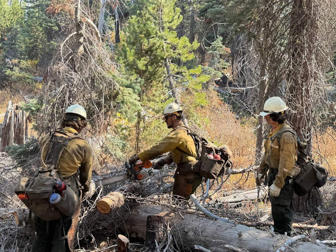
Dalton Hotshots performing chainsaw work on dead and down fuels in Division Mike.
Previous Information
Yosemite National Park Dome Fire Wednesday Morning, October 7, Update: 6,815 Acres with 41% Containment; Yosemite National Park is Open and Operating Normally, Cause is Under Investigation
Source: InciWeb
