


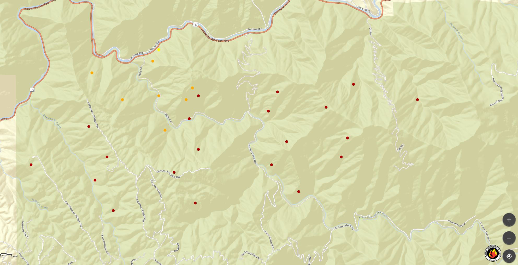
MODIS Map as of 4:15 A.M. Sunday
Click Here for Large Map
Fire Activity Detected by MODIS
Dark Red: Zero to 6 Hours
Light Red: Last 6 to 12 Hours
Orange: Last 12 to 24 Hours
Yellow: 6 Days Previous to Last 24 Hours
MODIS Active Fire Mapping Program Frequently Asked Questions

Click here for the Sierra Sun Times Scanner
Reminder: Scanner Information is NOT Official#FergusonFire
Click here for Saturday's Information on the Ferguson Fire
Update 6:00 P.M.: FERGUSON FIRE
Location: Merced River Canyon
Acres Burned: 4,310 acres
Structures Threatened: 108
Containment: 2%
Structures Destroyed: 0
Fire Started: July 13, 2018
Injuries: 0
Cause: Under Investigation
Fatalities: 1
Today crews improved structure protection measures along Highway 140 and continued to work to hold the fire north of Ferguson Ridge. The fire has slopped over Ferguson Ridge in several places and crews are working to secure this spread. Structure protection engines have arrived and are setting up to protect home and business between Cedar Lodge area and Hite’s Cove. Additional engines are being inserted into Jerseydale and Yosemite West to formulate structure protection plans. Firefighters have also begun construction of contingency lines along Sweetwater Ridge south of the fire and along Pinoche Ridge on the fires north flank. Firefighters are aggressively fighting the fire at locations where they have the highest probability of success and they have adequate time to construct the fire ahead of its advance.
Mandatory Evacuation: Areas that are currently under a mandatory evacuation include: Clearing House; Mariposa Pines; Cedar Lodge/Savage’s Trading Post and Sweetwater Ridge
Fire Advisement: Yosemite West and all of Jerseydale Road to Scott Road and Scott Road to Bear Clover are under Fire Advisement and should be prepared to evacuation should conditions change.
Road Closure: Highway 140 north of Mariposa remains closed due to firefighting activities and an on-going investigation into the fire’s cause. Hwy 140 is closed from Foresta Bridge to Briceburg. Other road closures included River Road from Briceburg to the gate at Railroad Flat and all Campground area closed. Hites Cover Road from Bear Clover Road to the Merced River.
Smoke Impacts: Smoke is expected to continue to impact adjoining communities, especially during night and early morning hours. You can learn more about air quality, and daily smoke forecasts by visiting either www.airnow.gov or www.valleyair.org.
Basic Information
|
Current as of |
7/15/2018, 5:43:53 PM |
|
Incident Type |
Wildfire |
|
Cause |
Unknown |
|
Date of Origin |
Friday July 13th, 2018 approx. 08:30 PM |
|
Location |
Savage Trading Post area |
|
Incident Commander |
Michael Strawhun, South Central Sierra Interagency Incident Management Team |
|
Coordinates |
37.652 latitude, -119.881 longitude |
Current Situation
|
Total Personnel |
500 |
|
Size |
4,310 Acres |
|
Percent of Perimeter Contained |
2% |
|
Fuels Involved |
Brush and timber, burning is steep inaccessible terrain. |
|
Significant Events |
Firefighters have been successful today in continuing to protect structures along the Main Fork of the Merced River. Mandatory evacuations remain in effect in Clearing House; Mariposa Pines; Cedar Lodge/Savage’s Trading Post and Sweetwater Ridge A Pre-evacuation Advisory has been issued for Yosemite West and along the Jerseydale Road to Scott Road and Scott Road to Bear Clover are under Fire Advisement. Residents should be prepared to evacuate should conditions change. Hwy 140 is closed from 1.9 miles east of Midpines to the Cedar Lodge area MOTORISTS ARE ADVISED TO USE AN ALTERNATE ROUTE |
Outlook
|
Remarks |
Smoke will likely impact the Merced River Corridor overnight. People with sensitivity to smoke should take precautions to limit exposure. |
Current Weather
|
Weather Concerns |
Weather is expected to remain hot and dry for the next seven days, with isolated thunderstorms possible over the Sierra crest. |
Source: Inciweb
Update 4:30 P.M.:
Photos of Ferguson Fire Near Yosemite National Park in Mariposa County
Update 2:10 P.M.: Half Dome: This view of Yosemite Valley from just east of Yosemite Village gives a sense of conditions of the floor of Yosemite Valley. You can help support this webcam and provide for the future of Yosemite by becoming a Friend of Yosemite today. (View webcam) 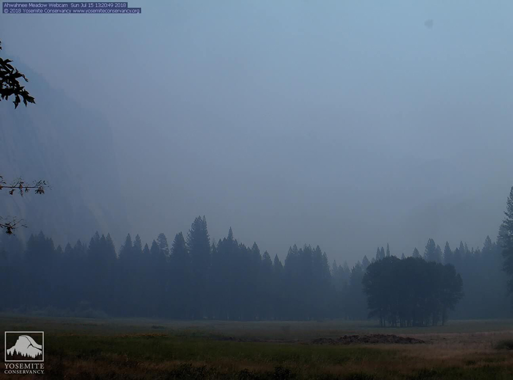 Photo credit: Yosemite Conservancy webcam
Update: 1:10 P.M.:
Smoke from Ferguson Fire in Mariposa County Creating Poor Visibility and Air Quality in Yosemite National Park
Update: 11:33 A.M.:
Basic Information
|
Current as of |
7/15/2018, 11:33:16 AM |
|
Incident Type |
Wildfire |
|
Cause |
Unknown |
|
Date of Origin |
Friday July 13th, 2018 approx. 08:30 PM |
|
Location |
Savage Trading Post area |
|
Incident Commander |
Michael Strawhun, South Central Sierra Interagency Incident Management Team |
|
Coordinates |
37.652 latitude, -119.881 longitude |
Current Situation
|
Total Personnel |
500 |
|
Size |
4,000 Acres |
|
Percent of Perimeter Contained |
2% |
|
Fuels Involved |
Brush and timber, burning is steep inaccessible terrain. |
|
Significant Events |
PG&E has deenergized the power lines running through the fire area, affecting Yosemite, El Portal and Foresta. Savages Trading Post and Ferguson Ridge Rd, Cedar Lodge and Redbud lodge were evacuated. Jerseydale and Mariposa Pines are under an evacuation order as of last night. Hwy 140 is closed from 1.9 miles east of Midpines to the Cedar Lodge area MOTORISTS ARE ADVISED TO USE AN ALTERNATE ROUTE |
Outlook
|
Remarks |
At 10:39 Mariposa Sheriff issued an evacuation advisory for Yosemite West Area. |
Current Weather
|
Weather Concerns |
Predicted triple digit heat today with slight chance of isolated thundershowers on the Sierra ridges. |
Source: Inciweb
Update: 11:16 A.M.: Mariposa County Sheriff's Office Issues A Fire Advisement for the Yosemite West Area of Mariposa County Due to the Ferguson Fire
Update: 9:35 A.M.: FERGUSON FIRE
Location: Merced River Canyon
Acres Burned: 4,000 acres
Structures Threatened:
Containment: 2%
Structures Destroyed: 0
Fire Started: July 13, 2018
Injuries: 0
Cause: Under Investigation
Fatalities: 1
Crews are focused on securing fire line along Highway 140 and protecting structures threatened along the corridor. Structure protection engines have arrived and setting up to protect home and business between Cedar Lodge area and Hite’s Cove. Additionally, crews are working to extend containment lines east on both the fires north and south flanks. Firefighters are scouting ridgelines to the east cut of spread up the South Fork of the Merced River toward Yosemite National Park. Firefighters are aggressively fighting the fire at locations where they have the high probability of success. However, they are challenged by extremely steep and hazardous terrain with limited road access.
Evacuation Status: Areas from Briceburg to east of Cedar Lodge remain evacuated. Jerseydale and Mariposa Pines are also under evacuation. The public is advised to remain prepared for changes in evacuations.
Highway Status: Highway 140 north of Mariposa remains closed due to firefighting activities and an on-going investigation into the fire’s cause. For updates on the status of the Highway 140 Closure visit Caltrans Road Condition Website at http://www.dot.ca.gov/cgi-bin/roads.cgi
Smoke Impacts: Smoke is expected to continue to impact adjoining communities, especially during night and early morning hours. You can learn more about air quality, and daily smoke forecasts by visiting either www.airnow.gov or www.valleyair.org.
Source: Inciweb
Update: 8:29 A.M.: Ferguson Fire in Mariposa County 4,000 Acres and 2% Contained
Total Personel: 500
Weather Concerns: Predicted triple digit heat today with slight chance of isolated thundershowers on the Sierra ridges.
Update: 8:15 A.M.: Mariposa County Air Pollution Control District Reports Ferguson Fire is Affecting Air Quality in the Area - Currently Unhealthy for Sensitive Groups
Update: 5:10 A.M.: Congressman Tom Mclintock Statement on the Death of CAL FIRE Firefighter Branden Varney of Mariposa County
July 15, 2018 - The Ferguson Fire is burning on the Sierra National Forest near Yosemite National Park in Mariposa County.
The Red Cross is opening a shelter for residents under mandatory evacuation for the #FergusonFire. Shelter location will be at New Life Christian Fellowship, 5089 Cole Rd, Mariposa, CA 95338. Please adhere to all mandatory evacuations.
Earlier Information:
A MANDATORY EVACUATION has been issued for the Jerseydale Area. This includes all residence on Jerseydale Rd, Hites Cove Rd and all side roads from Triangle Rd to the end of Hites Cove Rd. Please evacuate as soon as possible. Please drive with caution and watch for responding emergency traffic.
If you need assistance with large animal evacuation please call the Mariposa County Sheriff's Office at 209-966-3615.
