


Note: Click here for Tuesday's Dixie Fire Updates
Update: Dixie Fire East Zone Virtual Community Meeting Evening Update Video for Monday, September 6, 2021
Evening Update Per CAL FIRE: California Dixie Fire is at 914,655 Acres, with 58% Containment, and 4,584 personnel assigned for Monday evening.
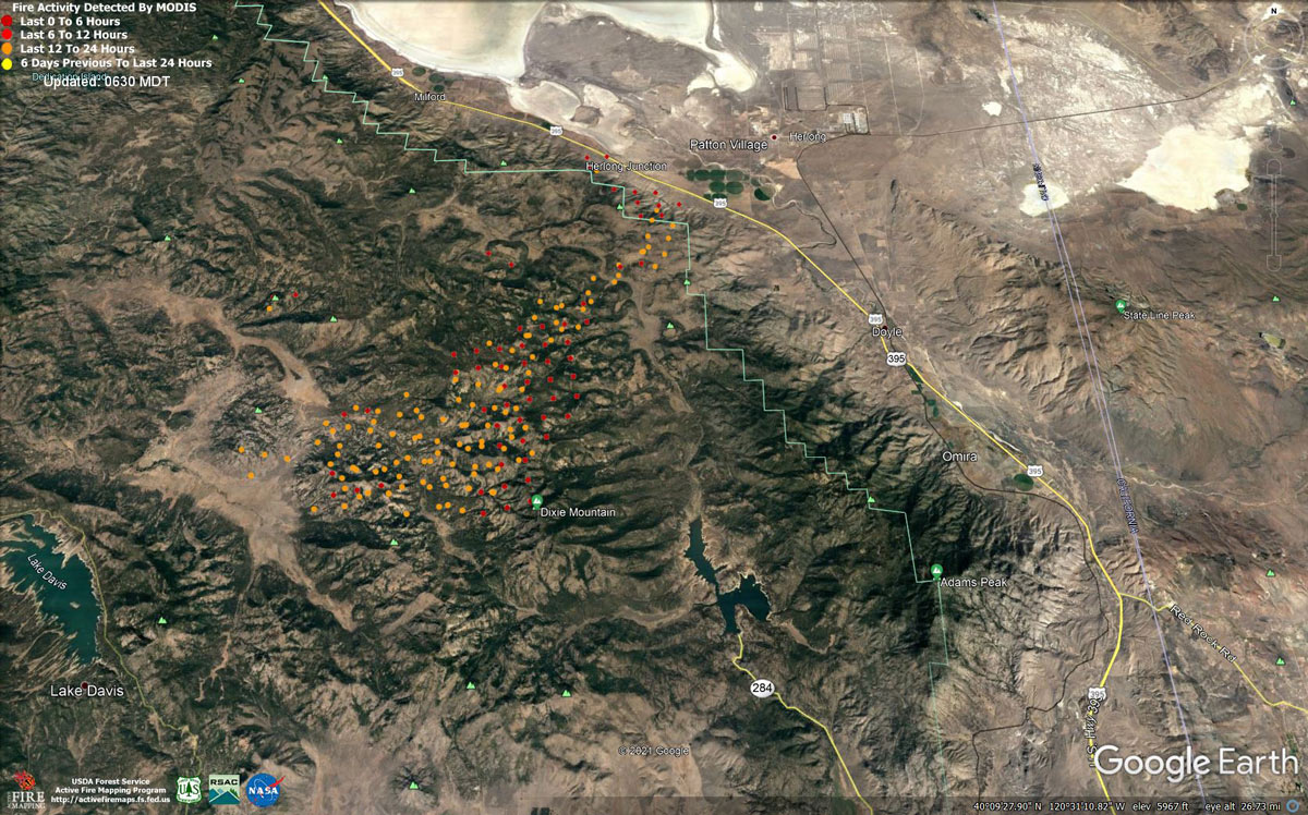
MODIS map of the Dixie Fire on Monday at 5:30 A.M PST
Note: 1,200 Pixels Wide - Note: Older Yellow not shown
MODIS Active Fire Mapping Program Frequently Asked Questions
Update: Dixie Fire Receives Assistance from Bureau of Land Management Nevada Ruby Mountain Hotshot Fire Crew
Update: Dixie Fire Virtual Community Meeting Set for 7:30 P.M. Tonight, September 6, 2021
Update: Dixie Fire West Zone Operations Morning Briefing Video for Monday, September 6, 2021
Update: Dixie Fire East Zone Morning Operations Briefing Video for Monday, September 6, 2021
Update: Smoke/Air Quality Outlook for the Dixie Fire in the Eastern Sierra for Monday, September 6, 2021
September 6, 2021 - Dixie Fire is 910,495 acres and 57% contained for Monday morning.
Dixie Fire Update for Monday, September 6, 2021
910,495 Acres
57% Containment
3,919 Total Personnel
Lassen and Plumas National Forests-The southeastern part of the Dixie Fire continues to produce extreme fire behavior daily, spreading south and east in very dry and receptive fuels. Smoke will linger in the valleys, with hot, dry, and breezy weather persisting for the next few days. Yesterday and overnight, the fire was very active in the Ross Canyon Area north of Dixie Valley, threatening structures and challenging firefighters. Today, firefighters will assess damaged structures on the north end of Dixie Valley. Hand and engine crews on the night shift strengthened containment lines, searched for spot fires around structures, and used water to extinguish the spots and cool down hot areas. To the east, fire in the Dixie Mountain State Game Refuge burned into the Sugar Fire scar. Strong west winds yesterday afternoon and evening pushed more fire off the escarpment above Highway 395 south of Milford, and fire backed down to containment lines at the base of the slope in a couple areas, where crews from both the West and East Zones worked together to contain it. Containment lines in the Coyote Hills area and on Turner and Grizzly Ridges held in place as crews used water to secure and reinforce the lines and cool interior hot spots. In the Devil’s Punchbowl area, south of Taylorsville, moderate fire behavior increases during the heat of the day. Crews will continue to closely monitor the activity and continue to cool it down with helicopter water drops. Structure protection continued overnight and will continue again today in the Dixie Valley, Beckwourth, Clover Valley, Portola, Greenhorn, Cromberg, Genesee, and Taylorsville.
Dixie Fire West Zone - The fire continues to burn out in the heavy material and was moderated by smoke settling over the fire area. Active fire was limited to ground fuels consisting of backing and flanking fire. Interior pockets continued to burn through the night well inside the fire perimeter. The diminishing humidity recovery aided in consumption of heavier fuels. Resources continue to use all firefighting methods available in the Lassen Volcanic National Park while maintaining firefighter safety. Crews will continue to work aggressively throughout the day to extinguish hot spots and improve lines. Crews will continue to construct direct and indirect line to secure the fire perimeter, construct contingency lines in both zones, and provide structure defense in communities at risk. Priority areas include Lassen Volcanic National Park, Old Station and surrounding communities, the HWY 395 escarpment areas including Janesville, Milford and Herlong. Crews from the West Zone continue to assist the East Zone. Several evacuation orders have been reduced to warnings and many warnings have been lifted allowing some residents to return to their homes and businesses. Residents are encouraged to stay vigilant and to monitor evacuation information and road closures, including social media and local law enforcement websites for the most current information.
Residents will see smoke coming from trees and stumps for days following their return. Proceed with caution because burned out areas may have unseen hazards. Residents are encouraged to call 911 if they are concerned about any active flames near their homes or businesses. Damage assessment remains ongoing. The change in the count of threatened structures in the update is due to new Evacuation Warnings in Lassen, Plumas and Shasta County.
Other - A firefighter assigned to the Dixie incident passed away on September 2, due to an illness.
CAL FIRE
'Click' here to view full PDF
Basic Information
| Current as of | 9/6/2021, 6:16:25 AM |
| Incident Type | Wildfire |
| Cause | Under Investigation |
| Date of Origin | Tuesday July 13th, 2021 approx. 05:15 PM |
| Location | Feather River Canyon near Cresta Powerhouse and Lake Almanor. |
| Incident Commander | Nick Truax, CALFIRE IMT 1 Evans Kuo, GBT1 Jay Lusher, NPS/BLM |
| Incident Description | Wildfire |
| Coordinates | 39.819 latitude, -121.419 longitude |
Current Situation
| Total Personnel | 3,847 |
| Size | 910,495 Acres |
| Percent of Perimeter Contained | 57% |
| Estimated Containment Date | Saturday October 30th, 2021 approx. 12:00 AM |
| Fuels Involved |
Fuel moistures are historically low, Energy Release Components and BI are in the 97-99%. Northern California remains under a Fuels and Fire Behavior Advisory. |
| Significant Events |
Extreme Wind Drive Runs Group Torching Short-range Spotting Narrative: The fire continues to burn out in the heavy material and was moderated by the smoke settling over the fire area. Active fire was limited to ground fuels, consisting of backing and flanking fire. Interior pockets continue to burn through the night, most are well interior of the perimeter. The diminishing humidity recovery aided in consumption of the heavier fuels. |
Outlook
| Planned Actions |
Planned Actions for the next Operational Period: Priority areas include: the Lassen & Shasta Sectors, Old Station and surrounding communities, the Highway 395 escarpment area including Janesville, Milford and Herlong Junction as well as Lake Davis and the Grizzly Creek area east of the escarpment. Communities of Greenhorn, Cromberg and Davis Lake also at risk, see "East Zone:" below. Continue to establish direct and indirect containment lines south of Old Station, utilizing lines created during the Reading incident. Resources continue to establish containment lines to hold the Hwy 44 corridor and monitor for spots across the highway, while protecting critical fiber optic infrastructure. Complete contingency lines both north and south of Janesville and Milford respectively. Monitor weather for predicted wind event in the area. Provide structure defense, while ensuring firefighter safety. Provide for service calls within communities impacted by the fire: Chester, Hwy 36 corridor, Hwy 89 Corridor, Hwy 395 corridor, Paxton, Greenville, Jonesville, Crescent Mills, Taylorsville, Prattville, Butte Meadows, Bucks Lake, Meadows Valley, Rush Creek, Warner Valley, Pecks Valley, Williams Valley, Hunt Canyon, Susanville, Janesville, and the Greater Almanor area. Continued mop up of and patrol of 1,000-hr fuels will require a significant amount of resources due to the volume of fuels and the steep and rugged terrain. Continued holding actions and point protection of communities and critical infrastructure will require a significant resource presence for the next several operational periods. East Zone: Resources will continue hold and improve dozer and handline from Lake Davis to Clover Valley, and then further north, to keep fire from spreading east towards Dixie Valley and north towards Milford, as well as south towards Clover Valley and Portola. Construct direct and indirect containment lines on the flanks of the fire edge to prevent fire from impacting Milford and Highway 395. Structure protection remains in place within Genesee and Taylorsville. |
| Projected Incident Activity |
12 hours: Light downslope and weak winds aloft kept thick smoke in place over the fire area, reducing visibility in many valleys. Poor relative humidity recoveries in the 20-30% range were observed with temperatures dropping into the mid to upper 30s in some valleys but mid and upper slopes remained in the lower to mid 50s. 24 hours: High pressure will bring temperatures with some lower valleys reaching the 90s Monday along with a very dry air mass remaining in place, resulting in critically low afternoon minimum relative humidity values and poor to moderate mid-slope recoveries through Tuesday. Temperatures will begin to decrease slightly Tuesday into the mid 80s. Light west to southwest wind is expected until a weather disturbance moves into the area Tuesday, when a more active weather pattern is possible starting midweek with increasing gusty winds. An increase in moisture is possible late in the week. Moderate to active fire behavior and moderate growth expected. 48 hours: Continued poor humidity recovery overnight, but some higher humidity air works in for the afternoon, possibly preventing the widespread below-10 percent RH conditions of the previous week and a half. High pressure will bring temperatures with some lower valleys reaching the 90s Monday along with a very dry air mass remaining in place, resulting in critically low afternoon minimum RH values and poor to moderate mid-slope recoveries through Tuesday. Moderate to active fire behavior and moderate growth expected. 72 hours: Temperatures will begin to decrease slightly Tuesday into the mid 80s. Light west to southwest wind is expected until a weather disturbance moves into the area Tuesday, when a more active weather pattern is possible starting midweek with increasing gusty winds. An increase in moisture is possible late in the week. Moderate activity and minimal growth expected. Anticipated after 72 hours: Temperatures will begin to decrease slightly Tuesday into the mid 80s. An increase in moisture is possible late in the week. Without a frontal passage, wind on Wednesday should be lighter. Continued cloud cover will mean cooler temperatures and continued higher humidity trend. The threat of thunderstorm from a monsoonal push from the Gulf of California has diminished this far north. Moderate activity and minimal growth expected. |
| Remarks |
Box 4: Great Basin Incident Management Team 1 (GBT1) is in command of the East Zone. East Zone Unified Command Agencies: Plumas National Forest and Lassen National Forest. CAL FIRE IMT 1 is in command of the West Zone. West Zone Unified Command Agencies: Bureau of Land Management, CAL FIRE, Lassen National Forest, National Park Service. Box 7: State DPA- 132,099; Federal DPA- 687,858; National Parks DPA- 65,569; Local DPA- 424; DOD DPA- 3 Box 25: The fire area is in portions of Butte, Lassen, Plumas, Shasta, and Tehama counties. Active fronts are in: Lassen NF, Lassen NP, and the Caribou Wilderness area; the lake Davis and Antelope Lake area; highway 395 adjacent to Honey Lake area, as well as on several private timber ownerships. Box 30E and 31H: Changed due to reduction in Plumas and Lassen County Evacuation Warnings and Orders. Box 31 (J): Indoor - 16 Outdoor - 6 Box 32 (D) : 1 fatality. The individual was previously identified as ill and passed away on the afternoon of September 2nd. Box 32(E): East Zone - 7 responder injuries, West Zone - 3 responder injuries Box 33: A State of Emergency for Butte, Lassen, and Plumas counties was declared by Governor Newsom on July 23rd, 2021. Butte, Lassen, Plumas, and Tehama Counties have declared local emergencies. FMAG has been approved for the Dixie Incident. Regional Order No. 21-04, effective August 22, 2021 through September 6, 2021, closes eight National Forests including Plumas, Lassen. The Plumas National Forest implemented Forest Order No. 05-11-00-21-18, effective from July 25, 2021, through September 30, 2021. The Lassen National Forest implemented Forest Order No. 06-21-07, effective from July 27, 2021, through September 30, 2021. Box 38: Additional values at risk threatened: National Scenic and Historic Trails: Pacific Crest Trail, Bizz Johnson National Recreation Trail Inventory Roadless Area (IRAs): Bucks Lake (PNF), Butt Mountain (PNF), Chips Creek (LNF), and Cub Creek (LNF). Experimental Forests: Swain Mountain, Blacks Mountain. Research Natural Areas (RNAs): Green Island Lake(LNF), Soda Ridge (LNF), Cub Creek (LNF), Mount Pleasant (PNF). Air Quality impacts: Reno, Carson City, Susanville, Sparks, Fernley and Quincy. Airports impacted by TFR and smoke impacts: Rogers Field (Chester Airport), Ganser Field (Quincy Airport), Westwood Airport, Susanville Municipal Airport, Herlong Airport Wilderness: Bucks Lake Wilderness (PNF), Caribou Wilderness (LNF), Lassen Volcanic National Park Wilderness. Commercial timber ownerships: Sierra Pacific Industries, W.M. Beaty and Associates, Collins Pine. An estimated $1 Billion dollars of timber has already been destroyed with an additional $1 Billion still threatened. Substantial losses of private and public timberlands have released decades of sequestered carbon, releasing it into the atmosphere with uncalculatable impacts to green house gas accumulations. Waterways: Philbrook Lake (PG&E, LNF), North Fork of the Feather River (PG&E, PNF), Silver Lake (Drinking water, PNF), Thompson Lake (Drinking water, PNF), Butte Creek (T&E species: chinook and steelhead, PNF), Deer Creek (T&E species: chinook and steelhead), Oliver Lake (T&E species: Sierra-Nevada Yellow-legged Frog, LNF), Gold Lake (T&E species: Sierra-Nevada Yellow-legged frog, PNF), Rock Lake (T&E species: Sierra-Nevada Yellow-legged frogs, PNF) Additional T&E species (not listed above): California Spotted Owl, Valley Elderberry Beetle, Shasta Crayfish, Cascades frog, California Red-Legged Frog, Bald Eagle, Golden Eagle, Grey wolf, Fisher, California wolverine, and Sierra Nevada red fox. Box 49: Database reconciliation is ongoing to correct resource discrepancies in the IROC and Isuite . |
Current Weather
| Weather Concerns |
Weather Concerns : Light terrain-driven winds less than 10 mph were present across much of the area through the late morning and early afternoon hours. A west to southwest wind developed across ridgelines especially on the western and southern peripheries of the fire area, with gusts not exceeding 20 mph. Valley areas and midslopes continued to have light terrain driven winds. Weak winds aloft allowed smoke to remain trapped across the area, resulting in poor visibility through the day. Temperatures increased from yesterday into the upper 80s to low 90s in valleys. Increasing temperatures were mitigated some due to smoke shading. Dry conditions continued with poor overnight RH recoveries falling below 10% in the afternoon. |
Click here for: California Dixie Fire Sunday, September 5, 2021 Updates
