


Note: Click Here for Dixie Fire Wednesday Updates
Update: Dixie Fire East Zone Evening Operations Briefing Video for Tuesday, September 7, 2021
Update: Dixie Fire West Zone Virtual Community Meeting Evening Update Video for Tuesday, September 7, 2021
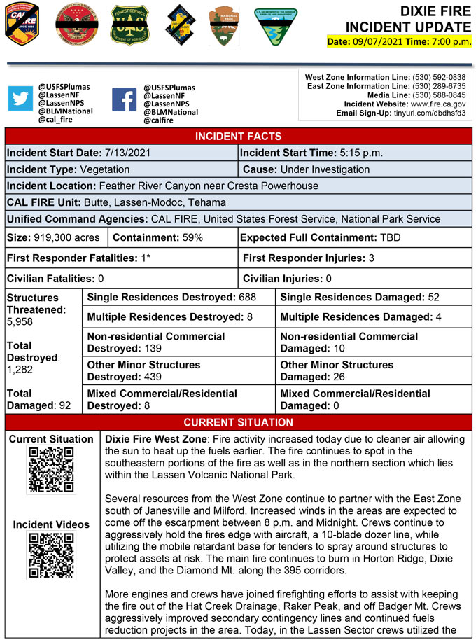
Evening Update Per CAL FIRE: California Dixie Fire is at 919,300 Acres, with 59% Containment, and 4,753 personnel assigned for Tuesday evening.
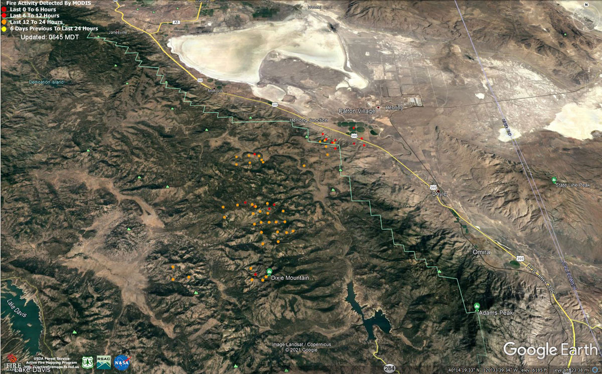
MODIS map of the Dixie Fire on Tuesday at 5:45 A.M PST
Note: 1,200 Pixels Wide - Note: Older Yellow not shown
MODIS Active Fire Mapping Program Frequently Asked Questions
12:12 P.M. Update: Dixie Fire Updates to Evacuation Orders, Warnings, and Road Information for Tuesday, September 7, 2021
Update: Dixie Fire East Zone Morning Operations Briefing Video for Tuesday, September 7, 2021
Update: Dixie Fire West Zone Operations Morning Briefing Video for Tuesday, September 7, 2021
Update: Smoke/Air Quality Outlook for the Dixie Fire in the Eastern Sierra for Tuesday, September 7, 2021
September 7, 2021 - Dixie Fire is 917,579 acres and 59% contained for Tuesday morning.
Update: 9:16 A.M.
917,579 Acres
59% Containment
4,673 Total Personnel
Lassen and Plumas National Forests - Firefighters expect hot daytime temperatures to continue for at least the next several days, with lighter southwest and westerly winds tomorrow, and only a slight increase in humidity. The forest is extremely dry, and the widespread fuel beds are quite receptive to sparks. The fire has moved by direct runs and torching of trees that throw embers over the lines causing spot fires. Firefighters expect moderate to active fire behavior today because of southwest winds in the middle of the day. More than 500 fresh firefighters joined the fight yesterday.
Yesterday and overnight, most of the fire perimeter remained quiet as hot spots were held in check behind containment lines. However, the far eastern and southeastern parts of the fire remain active today. Yesterday evening, fire crossed Highway 395 south of Milford and east of the escarpment, closing the highway for a little while. Crews from the West Zone were able to quickly catch the small spot-fire on the east side of the highway. Hot shot crews are working with West Zone resources to construct direct containment line on the northern flank of the fire near Highway 395. Hand crews and heavy equipment were successful building containment lines and keeping the fire from progressing southward in the Horton Ridge, Dixie Valley, and Dixie Mountain areas. Crews also improved contingency dozer lines located near Dotta Canyon and along the Beckwourth/Genesee Road. Fire continues to burn in very steep terrain of the Devil’s Punchbowl south of Taylorsville, and crews are monitoring it closely, using helicopters to keep it in place and cool it down. Crews used water to mop up all the heat within 100 feet around homes in Genesee Valley and continue to patrol and monitor the area. Unburned pockets in the interior of the fire will continue to burn out and produce smoke during the heat of the day.
Dixie Fire West Zone - The fire continued to burn into the evening and began to moderate after midnight. Smoke settled into the valleys on the northern portion of the fire. Active ground fire was observed throughout the night, with occasional single tree torching. Heavy down fuels actively consumed throughout the night. Crews will continue to complete line in steep and rugged terrain in the wilderness of Lassen National Volcanic Park using all firefighting strategies available. Resources continue to establish direct and indirect containment line south of Old Station utilizing lines created by the Reading incident. Resources continue to establish containment lines to hold HWY 44 and monitor for spots across the highway while protecting critical fiber optic cable. Crews are completing contingency lines both north and south of Janesville and Milford while monitoring for the predicted wind event today. Crews are providing structure defense while ensuring firefighter safety. Resources will continue to respond to service calls within communities impacted by the fire. Mop up and patrol status is currently being utilized in applicable areas. The high-pressure weather system will begin to weaken today with humidity remaining low and temperatures cooling slightly. Temperatures will be 83-91 degrees during the day. Humidity will be 8-12 percent with southwest winds up to 5-10 mph and gusts up to 15 mph in the afternoon.
CAL FIRE
'Click' here to view full PDF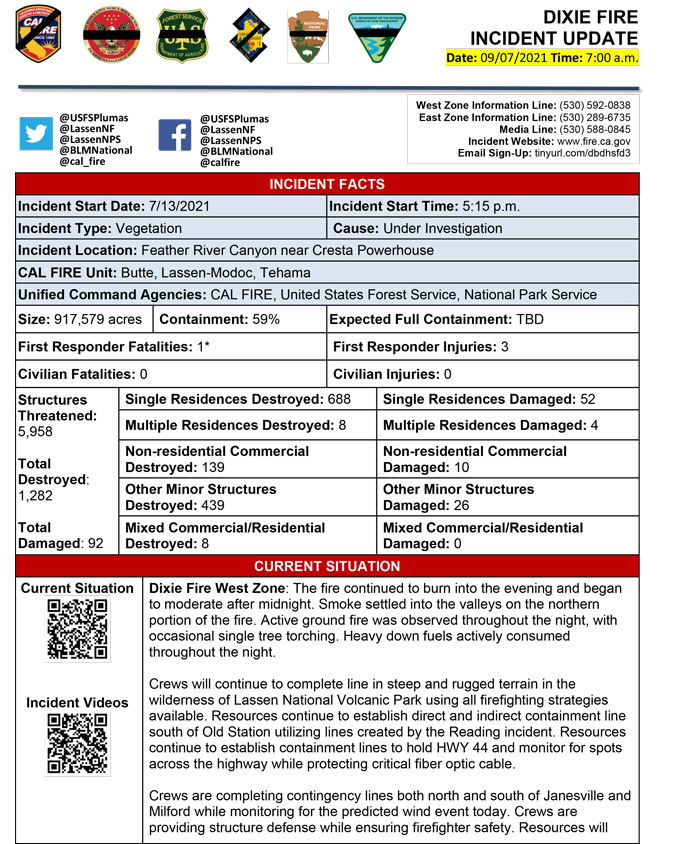
Basic Information
| Current as of | 9/7/2021, 7:04:34 AM |
| Incident Type | Wildfire |
| Cause | Under Investigation |
| Date of Origin | Tuesday July 13th, 2021 approx. 05:15 PM |
| Location | Feather River Canyon near Cresta Powerhouse and Lake Almanor. |
| Incident Commander | Nick Truax, CALFIRE IMT 1 Evans Kuo, GBT1 Jay Lusher, NPS/BLM |
| Incident Description | Wildfire |
| Coordinates | 39.819 latitude, -121.419 longitude |
Current Situation
| Total Personnel | 4,584 |
| Size | 917,579 Acres |
| Percent of Perimeter Contained | 59% |
| Estimated Containment Date | Saturday October 30th, 2021 approx. 12:00 AM |
| Fuels Involved |
Fuel moistures are historically low, Energy Release Components and BI are in the 97-99%. Northern California remains under a Fuels and Fire Behavior Advisory. |
| Significant Events |
Active Short Crown Runs Wind Driven Runs Short-range Spotting Active fire behavior due to hot/dry weather and very dry fuels. Interior pockets continue to burn and needle cast is creating potential for re-burn. Short range spotting observed. |
Outlook
| Planned Actions |
Planned Actions for the next Operational Period: Priority areas include: the Lassen & Shasta Sectors, Old Station and surrounding communities, the Highway 395 escarpment area including Janesville, Milford and Herlong Junction as well as Lake Davis and the Grizzly Creek area east of the escarpment. Communities of Greenhorn, Cromberg and Davis Lake also at risk, see "East Zone:" below. Continue to establish direct and indirect containment lines south of Old Station, utilizing lines created during the Reading incident. Resources continue to establish containment lines to hold the Hwy 44 corridor and monitor for spots across the highway, while protecting critical fiber optic infrastructure. Complete contingency lines both north and south of Janesville and Milford respectively. Monitor weather for predicted wind event in the area. Provide structure defense, while ensuring firefighter safety. Provide for service calls within communities impacted by the fire: Chester, Hwy 36 corridor, Hwy 89 Corridor, Hwy 395 corridor, Paxton, Greenville, Jonesville, Crescent Mills, Taylorsville, Prattville, Butte Meadows, Bucks Lake, Meadows Valley, Rush Creek, Warner Valley, Pecks Valley, Williams Valley, Hunt Canyon, Susanville, Janesville, and the Greater Almanor area. Continued mop up of and patrol of 1,000-hr fuels will require a significant amount of resources due to the volume of fuels and the steep and rugged terrain. Continued holding actions and point protection of communities and critical infrastructure will require a significant resource presence for the next several operational periods. East Zone: Resources will continue hold and improve dozer and handline from Lake Davis to Clover Valley to keep fire from spreading east towards Dixie Valley and north towards Milford, as well as south towards Clover Valley and Portola. Construct direct and indirect containment lines on the flanks of the fire edge to prevent fire from impacting Milford, Highway 395, and Dixie Valley. Construct dozer line along the powerlines east of Road 177. Continue improving Road 177 as a secondary control line. Structure protection remains in place within Genesee and Taylorsville. |
| Projected Incident Activity |
12 hours: Stagnant atmosphere with a strong inversion will trap smoke in valleys. Drainage wind will bring the smoke generally southward into Highway 70 and other communities. Humidity recovery overnight will remain poor. Gusty wind along the escarpment will continue into the late night hours, threatening US-395. Active to extreme fire behavior along Horton Ridge and the Dixie Valley. The complex terrain in Horton ridge and variable fuels increases the potential for rapid rates of spread and resistance to containment. Westerly winds have the potential to push the fire down the escarpment in the Diamond Mountains above US-395. Spotting potential 1/4 - 1/2 mi. Fire expected to burn actively through the night. 24 hours: Tuesday will be the hottest day of the current heat wave. Wind will be down slightly from Labor Day, with the exception of the escarpment area. Higher humidity will move with expected afternoon readings near 10 to 15 percent. Active to extreme fire behavior due to hot/dry conditions and fuel receptivity. Main fire continues to burn in the Dixie Valley and along the Diamond Mountains above US-395. Short range spotting potential 1/4-1/2 mi. 48 hours: be less than Tuesday night. The high humidity air that moved into the region on Tuesday will produce some cloud cover. Temperatures will cool slightly, and humidity will be slightly higher. Active fire behavior due to hot, dry and windy conditions. Main fire continues to burn along Horton ridge, Dixie Valley and Diamond Mountains. 72 hours: Continued southwest ridge winds gusting to 25 mph, with higher gusts on the escarpment. Temperatures continue a gradual cool down as more cloud cover arrives. This will continue the trend of slightly higher afternoon humidity. Moderate to active fire behavior predominately along Horton Ridge. Anticipated after 72 hours: Neither precipitation or thunderstorm activity expected for at least seven days. Skies will become cloud free again by Sunday. Above normal temperatures and afternoon ridge winds gusting as strong as 27 mph will continue, generally from a southwest direction. Moderate activity and minimal growth expected. |
| Remarks |
Box 4: Great Basin Incident Management Team 1 (GBT1) is in command of the East Zone. East Zone Unified Command Agencies: Plumas National Forest and Lassen National Forest. CAL FIRE IMT 1 is in command of the West Zone. West Zone Unified Command Agencies: Bureau of Land Management, CAL FIRE, Lassen National Forest, National Park Service. Box 7: State DPA- 132,099; Federal DPA- 687,858; National Parks DPA- 65,569; Local DPA- 424; DOD DPA- 3 Box 25: The fire area is in portions of Butte, Lassen, Plumas, Shasta, and Tehama counties. Active fronts are in: Lassen NF, Lassen NP, and the Caribou Wilderness area; the lake Davis and Antelope Lake area; highway 395 adjacent to Honey Lake area, as well as on several private timber ownerships. Box 30: Structures possibly damaged in Dixie Valley area. Waiting on a DINS assessment to validate damage. Box 31 (J): Indoor - 16 Outdoor - 6 Box 32(E): East Zone - 7 responder injuries, West Zone - 3 responder injuries Box 33: A State of Emergency for Butte, Lassen, and Plumas counties was declared by Governor Newsom on July 23rd, 2021. Butte, Lassen, Plumas, and Tehama Counties have declared local emergencies. FMAG has been approved for the Dixie Incident. Regional Order No. 21-04, effective August 22, 2021 through September 6, 2021, closes eight National Forests including Plumas, Lassen. The Plumas National Forest implemented Forest Order No. 05-11-00-21-18, effective from July 25, 2021, through September 30, 2021. The Lassen National Forest implemented Forest Order No. 06-21-07, effective from July 27, 2021, through September 30, 2021. Box 38: Additional values at risk threatened: National Scenic and Historic Trails: Pacific Crest Trail, Bizz Johnson National Recreation Trail Inventory Roadless Area (IRAs): Bucks Lake (PNF), Butt Mountain (PNF), Chips Creek (LNF), and Cub Creek (LNF). Experimental Forests: Swain Mountain, Blacks Mountain. Research Natural Areas (RNAs): Green Island Lake(LNF), Soda Ridge (LNF), Cub Creek (LNF), Mount Pleasant (PNF). Air Quality impacts: Reno, Carson City, Susanville, Sparks, Fernley and Quincy. Airports impacted by TFR and smoke impacts: Rogers Field (Chester Airport), Ganser Field (Quincy Airport), Westwood Airport, Susanville Municipal Airport, Herlong Airport Wilderness: Bucks Lake Wilderness (PNF), Caribou Wilderness (LNF), Lassen Volcanic National Park Wilderness. Commercial timber ownerships: Sierra Pacific Industries, W.M. Beaty and Associates, Collins Pine. An estimated $1 Billion dollars of timber has already been destroyed with an additional $1 Billion still threatened. Substantial losses of private and public timberlands have released decades of sequestered carbon, releasing it into the atmosphere with uncalculatable impacts to green house gas accumulations. Waterways: Philbrook Lake (PG&E, LNF), North Fork of the Feather River (PG&E, PNF), Silver Lake (Drinking water, PNF), Thompson Lake (Drinking water, PNF), Butte Creek (T&E species: chinook and steelhead, PNF), Deer Creek (T&E species: chinook and steelhead), Oliver Lake (T&E species: Sierra-Nevada Yellow-legged Frog, LNF), Gold Lake (T&E species: Sierra-Nevada Yellow-legged frog, PNF), Rock Lake (T&E species: Sierra-Nevada Yellow-legged frogs, PNF) Additional T&E species (not listed above): California Spotted Owl, Valley Elderberry Beetle, Shasta Crayfish, Cascades frog, California Red-Legged Frog, Bald Eagle, Golden Eagle, Grey wolf, Fisher, California wolverine, and Sierra Nevada red fox. Box 49: Database reconciliation is ongoing in both Finance and Planning sections. |
Current Weather
| Weather Concerns |
Near-record heat (valley highs reaching into the middle 90s) during the afternoon pushed humidity below 10 percent, ridge winds gusted up to 27 mph from the southwest. The high pressure is centered over central Nevada and shows no sign of breaking down and moving away for the next seven days. Dry conditions continued with poor overnight relative humidity recoveries falling below 10% in the afternoon. |
Click here for: California Dixie Fire Monday, September 6, 2021 Updates
