


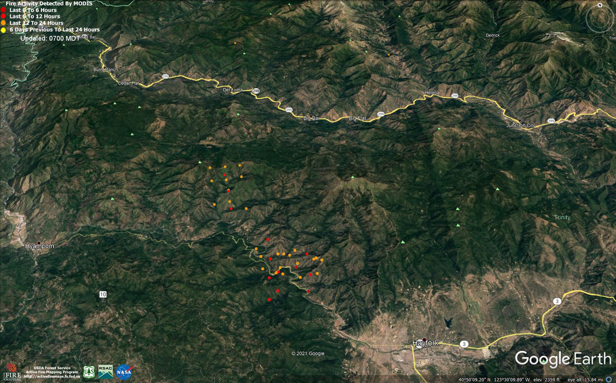
MODIS map of the Monument Fire on Tuesday at 6:00 A.M PST
Note: 1,200 Pixels Wide - Note: Older Yellow not shown
MODIS Active Fire Mapping Program Frequently Asked Questions
Note: Click here for Monument Fire Updates for Wednesday
Evening Update Per CAL FIRE: Monument Fire is at 185,919 Acres with 42% Containment, and 2,034 Personnel assigned for Tuesday evening.
Basic Information
| Current as of | 9/7/2021, 7:25:14 PM |
| Incident Type | Wildfire |
| Cause | Lightning |
| Date of Origin | Friday July 30th, 2021 approx. 06:00 PM |
| Location | Del Loma, CA near Monument Peak |
| Incident Commander | Rick Young, ICT1 CIIMT5 and Mike Parkes, ICT1 CAL FIRE IMT |
| Incident Description | Wildfire |
| Coordinates | 40.752 latitude, -123.337 longitude |
Current Situation
| Total Personnel | 2,034 |
| Size | 185,919 Acres |
| Percent of Perimeter Contained | 42% |
| Estimated Containment Date | Monday November 01st, 2021 approx. 08:00 AM |
| Fuels Involved |
The fire remains within the 2008 Buckhorn, Eagle, Miners and Cedar Fire footprints. Converted brush and a heavy dead and downed component dominate most areas. Fuels to the north of Hayfork are characterized as widely spaced mixed conifer and grass. All live fuels are cured to levels normally seen in late September. |
| Significant Events |
Active Uphill Runs Group Torching Short-range Spotting Active fire behavior. High resistance to control. Fair to locally poor RH recovery again promoted an earlier peak burn period. A hot, unstable airmass at the surface supported steady fire spread in all fuel types. Fire growth was primarily a function of aggressive surface fire; short uphill runs, group tree torching, short range spotting and roll-out due to steep, complex terrain. Afternoon heating provided new growth opportunities west of Hayfork towards Hyampom and south towards Indian Valley. Additional expansion continued into the well aligned topography north of the 299 corridor within the designated wilderness towards Green Mountain and Thurston Peaks. East of Hoboken, fire continues to make a consistent flanking action along the south slopes of Big Mountain towards New River. |
Outlook
| Planned Actions |
Protect communities of Hayfork, Hyampom, East Fork of New River, Weaverville and Junction City by providing structure defense. Perform direct and indirect line construction in Divisions U, W, and Z. Continue to hold, improve, mop-up, and patrol existing containment lines. Continue contingency line and structure preparation in Division K. |
| Projected Incident Activity |
12 hrs: Despite diurnal nighttime winds and shorter days, fire behavior will only slightly temper under locally "fair to poor" relative humidity recovery. The contribution of fine fuels to fire spread will only diminish for sveral hours during the night. Drainage winds will continue to steer established, deep seated fire both west and east along the Hayfork Creek corridor; sustaining an ongoing threat to the communities of Hyampom and Hayfork. Indian Valley is threatened with any new growth south of Hayfork Creek. Continued fire activity along the south and west slopes of Big Mountain will maintain a threat to the New River corridor, and the community of Hoboken. 24 hrs: Extreme fire behavior possible. High resistance to control. Expect enhanced growth potential with forecast convective activity associated with a very unstable airmass over the region. Expect active burning with elongated burn periods well past sunset. Very dry large fuels and fully available fine fuels will contribute to unimpeded growth where any fuel continuity exists and suppression resources do not. Daily diurnal wind flow will again steer established deep seated fire mainly along the Hayfork Creek corridor, providing an ongoing threat to the communities of Hayfork and Hyampom. Indian Valley is threatened with any new growth south of Hayfork Creek. Expect northerly spread into the high elevation wilderness below Green Mountain and Thurston Peaks. Continued active burning, north of Ironside Mountain, will represent a threat to Denny. |
| Remarks |
Block 48: CA-CDF row includes all resources that are assigned to the State Mission that was previously the South Zone of the Monument Fire. Resource counts: chippers and excavators have been included with Track Vehicles. All State Resources from states other than CA were consolidated under the State Column. |
Current Weather
| Weather Concerns |
Another hot and dry day, as the upper ridge breaks down and an upper trough sweeps by to the northwest. This close proximity has increased south to southwest winds across the fire area, has improved ventilation, and was the main impetus for the issuance of a Red Flag Warning for today for the Monument and Knob Fires, in effect from 1000 to 2000. Max Temperatures: 90s to around 100F Minimum Humidity: 7-11% 20 ft Winds: Upper Slopes & Ridges: ENE to ESE morning 2-4 mph gusts to 7 mph, becoming SSW 6-10 mph gusts 18-22 mph into the afternoon and evening. Trinity River Basin: Down-canyon 1-3 mph with gusts to 6 mph through 1300, then up-canyon 5-8 mph gusts to 17-20 mph in the afternoon and evening. Forecast: Breezy conditions will taper through late evening and transition to down-canyon by midnight. Temperatures will fall into the mid 50s to mid 60s across the fire, with poor to moderate humidity recoveries anticipated. Southwest flow aloft will remain in place across the region tomorrow, producing partly cloudy skies along with patchy smoke in the low-lying valleys. Afternoon temperatures are forecast to be a couple degrees cooler, minimum relative humidity will be a few percent higher, and south west winds will gust up to 20 mph at times through the mid and late afternoon over the higher exposed area. |
Update: Monument Fire Evacuation Information & Updates for Tuesday, September 7, 2021
September 7, 2021 - Monument Fire Update for Tuesday Morning, 185,505 acres with 41% containment.
Udate 10:40 A.M.
MONUMENT FIRE:
Resources: 2,466 personnel, 35 hand crews, 164 engines, 4 helicopters, 45 dozers, 36 water tenders, 15 masticators
Current Situation: The Monument Fire is approximately 185,505 acres and 41% contained. Within the fire perimeter, two areas remain the focus: the north side, which is primarily in the Trinity Alps Wilderness, and the southwest side, which is east of Hyampom and northwest of Hayfork. Suppression efforts are being implemented to protect the Trinity Alps Wilderness, the Trinity Wild and Scenic River, Inventoried Roadless Areas, and endangered species habitat.
Yesterday, the fire progressed downslope toward James Creek and Hyampom Road at a moderate pace. It reached Hyampom Road at a couple points east of Nine-Mile Bridge, where crews were positioned to hold the fire. However, weather conditions worsened and winds increased, causing the fire to spot in several locations south of Hyampom Road. Firefighters were able to suppress and contain most of the spot fires, but one became established south of Nine-Mile Bridge and is estimated to be around 300 acres.
Today, the highest priority will be to construct a containment line around the 300-acre spot fire south of Nine-Mile Bridge and to protect any structures south of Hyampom Road. Crews will also continue to work on Pattison Ridge securing containment lines and conducting firing operations toward Hayfork Creek. A mobile fire-retardant base has been established and is available to help fire suppression efforts along the southwest fire perimeter. As the smoke lifts, helicopters will be utilized to drop retardant and water in active fire areas. On the northern perimeter, gusty winds are predicted this afternoon which will increase fire activity in the area below Thurston Peak in the Trinity Alps Wilderness. Firefighters will continue to work on improving contingency lines along Backbone Ridge. The North Fork Trinity River is located in a deep drainage, sheltered from the wind, which has moderated fire activity. The fire had not crossed to the east side of the river. Containment line elsewhere around the fire perimeter continues to be monitored and patrolled.
KNOB FIRE:
Resources: 229 personnel, 7 hand crews, 30 engines, 2 dozers, 2 water tenders
Current Situation: The Knob Fire is approximately 2,414 acres and 89% contained. Last night fire behavior was minimal, with no spotting outside of the fire perimeter. Today, crews will continue to work on the north side strengthening and improving containment lines and extinguishing any hotspots within 300 feet of the perimeter of the fire.
WEATHER AND FIRE BEHAVIOR: Poor overnight humidity recovery and extremely dry, hot weather will persist through today. These conditions, combined with today’s gusty winds, have led incident meteorologists to issue a local Red Flag Warning that is in effect from 10 A.M. to 8 P.M. Incident firebehavior analysists have cautioned fire managers and crews that they will see atmospheric instability; hot, dry weather; winds aligning with topography; and dry vegetation, which will result in moderate to extreme fire behavior. Firefighters have been cautioned to expect long-range spotting and crown fires, particularly on the fire’s north side.
MONUMENT FIRE ROAD CLOSURES AND RESTRICTIONS (Trinity County):
• East of Hyampom: Hyampom Road between Lucky Jeep Trail and Halfway Ridge
• Northeast of Hayfork: Big Creek Road, Barker Valley Road, Barker Creek Road, Carr Creek Road
• West of Junction City: Big French Creek Road, Big Mountain Road, Soldier Creek Road
• A segment of State Route 299 between mile post 7.4 (near Burnt Ranch at Berg Road) and mile post 36.3 (just west of Helena) is open to through traffic and residents on the following schedule: Monday through Sunday, from 7 A.M. to 7 P.M., an escort vehicle leads traffic through the closure every 1.5 hours. Overnight, from 7 P.M. to 7 A.M., the road is open only to residents with proof of address.
KNOB FIRE ROAD CLOSURES (Humboldt County):
• China Creek Road at Hodgson Road
• Friday Ridge Road
• Panther Road
MONUMENT FIRE EVACUATIONS (Trinity County): This information can change at any time, and residents are advised to monitor the Trinity County Sheriff’s Office Facebook page for the latest information at Trinity County Sheriff’s Office Facebook, or call 530-623-2611.
• Issued September 6th at 8 P.M. Order: All areas along both sides of Hyampom Road between Lucky Jeep Trail and Drink Water Gulch, including Fox Lane, Drink Water Gulch, and Phares Lane
• Order: All areas along Hyampom Road between Lucky Jeep Trail and Halfway Ridge
• Order: Helena/East Fork Road, Hobo Gulch Road, Big Mountain Road, and Big French Creek Road.
• Issued September 6th at 8 P.M. Warning: All areas along Hyampom Road east of Drink Water Gulch to Digger Gulch and South to Tule Creek Road and Green Gate Road, including Turkey Track Road, Doctor Lane, Digger Gulch, Shangri La Lane, Green Gate Road, McAlexander Road
• Warning: Denny Road east from Ziegler Point Road through Denny to the Trinity Alps Wilderness Area boundary
• Warning: Section of Campbell Ridge Road and Woods Lane near the Trinity River along the Humboldt/Trinity County line
• Warning: Canyon Creek Road in Junction City
KNOB FIRE EVACUATIONS (Humboldt County): This information can change at any time, and residents are advised to monitor the Humboldt County Sheriff’s Office webpage for the latest information at humboldtsheriff.org, tinyurl.com/humcoevacmap, or call 707-268-2500.
• Order: Areas east of Brushy Mountain Lookout Road/FS Road 6N08A to State Route 299, south of Victor Creek to China Creek
• Order: Areas east of Brushy Mountain Lookout Road/FS Road 6N08A to the eastern perimeter of the Knob Fire south of China Creek to Friday Ridge Road
• Order: Areas east of Brushy Mountain Lookout Road/FS 6N08A to the South Fork Trinity River, south of Friday Ridge Road to the end of the FS Road 6N20
• Warning: Areas of Boise Creek to the Humboldt/Trinity County line, south of the Trinity River to Victor Creek
• Warning: Areas east of State Route 299 to the Humboldt/Trinity County line, south of Victor Creek to China Creek
• Warning: Areas east of the Knob Fire perimeter to the Humboldt/Trinity County line, south of China Creek to Friday Ridge Road
EVACUATION CENTERS: American Red Cross, California Northwest Chapter, 707-832-5480
• McKinleyville Seventh Day Adventist, 1200 Central Avenue, McKinleyville
• Fireman’s Hall Pavilion, 9 Park Street, Fortuna
FOREST CLOSURE: The USDA Forest Service has temporarily closed all National Forests in California. Direct questions to 707-562-9113 or SM.FS.R5inquiries@usda.gov.
Basic Information
| Current as of | 9/7/2021, 8:23:14 AM |
| Incident Type | Wildfire |
| Cause | Lightning |
| Date of Origin | Friday July 30th, 2021 approx. 06:00 PM |
| Location | Del Loma, CA near Monument Peak |
| Incident Commander | Rick Young, ICT1 CIIMT5 and Mike Parkes, ICT1 CAL FIRE IMT |
| Incident Description | Wildfire |
| Coordinates | 40.752 latitude, -123.337 longitude |
Current Situation
| Total Personnel | 2,466 |
| Size | 185,505 Acres |
| Percent of Perimeter Contained | 41% |
| Estimated Containment Date | Monday November 01st, 2021 approx. 08:00 AM |
| Fuels Involved |
The fire remains within the 2008 Buckhorn, Eagle, Miners and Cedar Fire footprints. Converted brush and a heavy dead and downed component dominate most areas. Fuels to the north of Hayfork are characterized as widely spaced mixed conifer and grass. All live fuels are cured to levels normally seen in late September. |
| Significant Events |
Overnight Fire behavior was erratic with isolated torching, and spotting, with group tree torching observed. The fire is burning in areas with no recent fire history. Crews continued to prep and perform firing along established lines as the fire progressed to secure containment in Branch 40. Crews patrolled and monitored the remaining perimeter. The fire generally remains within the 2006 Pigeon Fire and 2015 Happy Fire scars, as well as the 2008 Cedar, Eagle, Miners, and Buckhorn Fire footprints. Type converted brush and a heavy dead and down component dominate most areas. All live fuels are cured to levels normally seen in late September. |
Outlook
| Planned Actions |
The Shasta-Trinity National Forest has provided the following priorities: 1.Reduce impacts of southwestern progression to Hayfork and Hyampom while maintaining access to Hyampom, 2. Minimize impact for values at risk to the northwest side of the fire including Burnt Ranch, Hawkins Bar, Trinity Village, Bell Flat, Daily, and Denny. Provide structure defense for the communities of Burnt Ranch, Friedrich Road, Hawkins Bar, Trinity Village, Cedar Flat, Underwood Mountain, 9-Mile Bridge, and Bar 717. In the southwest segment of the fire, patrol and mop-up along Corral Bottom Road/47 Road and Prodigy site. Continue direct handline down Haypress Road. Continue developing and improving primary indirect line along Pattison Road to Pattison Ridge, Pattison Peak Road, down through Halfway Ridge and east to Jud Creek tying in at 9-Mile Bridge to connect with the South Zone. Provide structure defense for the communities from Helena east through Junction City and north along Canyon Creek and the East Fork of the North Fork River. Reinforce indirect line north of the New River from Happy Camp Mountain to the confluence of the Trinity River. Take action on any spots across and west of the New River. Prepare structures along the New River from Five Waters northward towards Denny. Continue to mop up and patrol along the south portion of the fire in Divisions NN and RR, north of Hayfork to the western zone break. Continue fire suppression repair in Div DD, HH, and NN. Begin planning for the demobilization of excess equipment and personnel. Branch 40 resources will continue to Patrol and mop-up from DP-50 north along the N23 and 60 roads to DP-61 at Fredricks Ridge as well as providing structure defense and additional mop up to the extent necessary to maintain containment. Be prepared to support Branch 50 if necessary. Prepare and fire from DP-48 to H-105 as conditions permit and approved by Operations. Branch 50 (Knob Fire) is addressed on the Knob Fire morning report. Critical resource needs remain the same as last night’s 209. |
| Projected Incident Activity |
12 hrs: With diurnal nighttime winds and shorter days, fire behavior will gradually temper under locally "fair" relative humidity recovery. The contribution of fine fuels to fire spread will diminish throughout the burn period. Wind flow will continue to steer established, deep seated fire both west and east along the Hayfork Creek corridor; sustaining an ongoing threat to the communities of Hyampom and Hayfork. Continued fire activity along the south slopes of Big Mountain will maintain a threat to the New River corridor, and the community of Hoboken. 24 hrs: Active fire behavior. High resistance to control. Expect active burning with elongated burn periods; well past sunset. Very dry large fuels and fully available fine fuels will contribute to unimpeded growth where any fuel continuity exists and suppression resources do not. Daily diurnal wind flow will again steer established, deep seated fire mainly along the Hayfork Creek corridor; providing an ongoing threat to the communities of Hayfork and Hyampom. Expect northerly spread into the high elevation wilderness below Green Mountain and Thurston Peaks. Continued active burning, north of Ironside Mountain, will represent a threat to Denny. |
Current Weather
| Weather Concerns |
Hot and dry once again as the upper ridge of high pressure remained in place. Typical upslope/up-canyon winds were reported through the afternoon with generally lighter speeds due to smoke moderation, especially in the valleys. Ridges and higher exposed slopes experienced stronger afternoon gusts. An unstable air mass persisted above the smoke layer again today with subsequent impacts to fire activity across areas that experienced clearing. Observed: Max Temperatures: Upper 80s to upper 90s Minimum Humidity: 7-14% 20 ft Winds: Upper Slopes & Ridges: ENE to ESE morning 2-4 mph gusts 7-12 mph, becoming SSW 6-10 mph gusts 15 mph into the afternoon and evening. Trinity River Basin: Down-canyon 3-5 mph with gusts to 12 mph through 1300, then up-canyon 4-6 mph gusts to 15 mph in the afternoon and evening. Forecast: Breezy conditions will taper by the evening and transition to down-canyon by midnight. Temperatures will fall into the mid to upper 50s in valleys and mid to upper 60s in thermal belts, with very poor humidity recoveries expected overnight. An upper disturbance brushing by to the west tomorrow will bring partly cloudy skies and increased wind speeds across the higher exposed ridges by midday, with gusts to 25 mph possible. Hot and dry conditions will persist, though humidity levels may stay above the single digits. |
Click here for:California Monument Fire Monday, September 6, 2021 Updates
