


Note: Click here for Thursday's Dixie Fire Updates
Update: Dixie Fire East Zone Virtual Community Meeting Evening Update Video for Wednesday, September 8, 2021
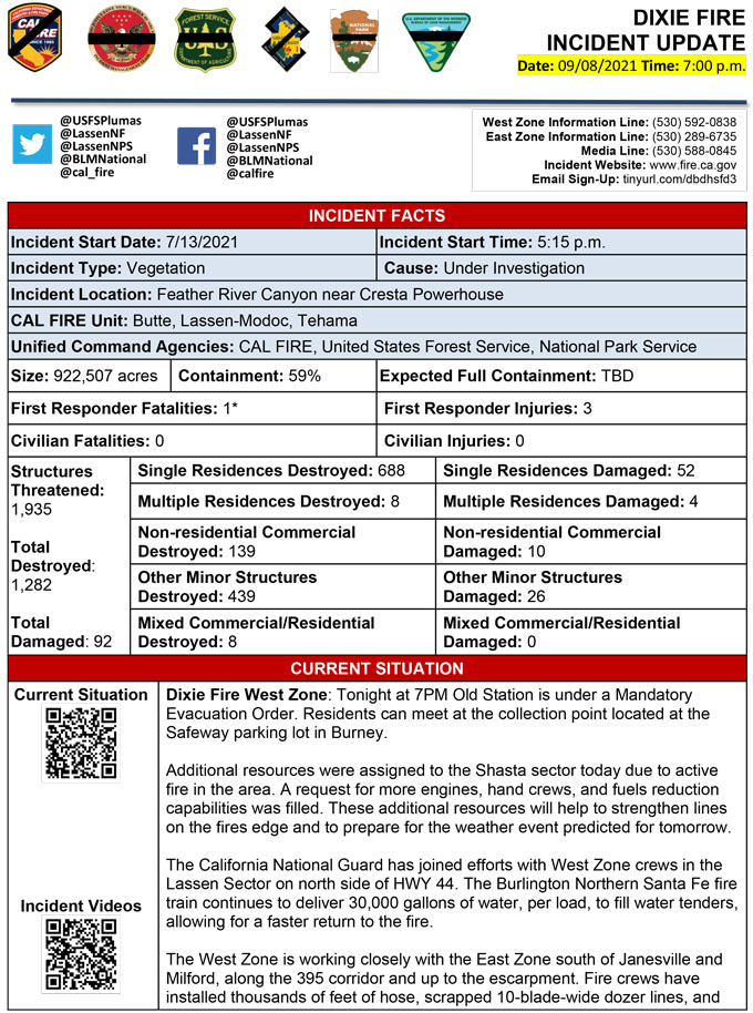
Evening Update Per CAL FIRE: California Dixie Fire is at 922,507 Acres, with 59% Containment, and 4,876 personnel assigned for Wednesday evening.
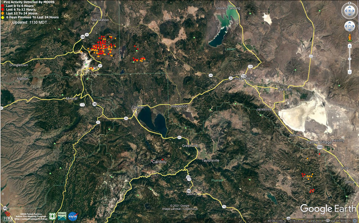 MODIS map of the Dixie Fire on Wednesday at 10:30 A.M PST
Note: 1,200 Pixels Wide - Note: Older Yellow not shown
MODIS Active Fire Mapping Program Frequently Asked Questions
Update: Dixie Fire Virtual Community Meeting Set for 7:30 P.M. Tonight, September 8, 2021
7:45 P.M. Update: Dixie Fire Updates to Evacuation Orders, Warnings, and Road Information for Wednesday, September 8, 2021
Update: Dixie Fire East Zone Morning Operations Briefing Video for Wednesday, September 8, 2021
Update: Dixie Fire West Zone Operations Morning Briefing Video for Wednesday, September 8, 2021
Update: Smoke/Air Quality Outlook for the Dixie Fire in the Eastern Sierra for Wednesday, September 8, 2021
September 8, 2021 - Dixie Fire is 922,192 acres and 59% contained for Wednesday morning.
CAL FIRE
'Click' here to view full PDF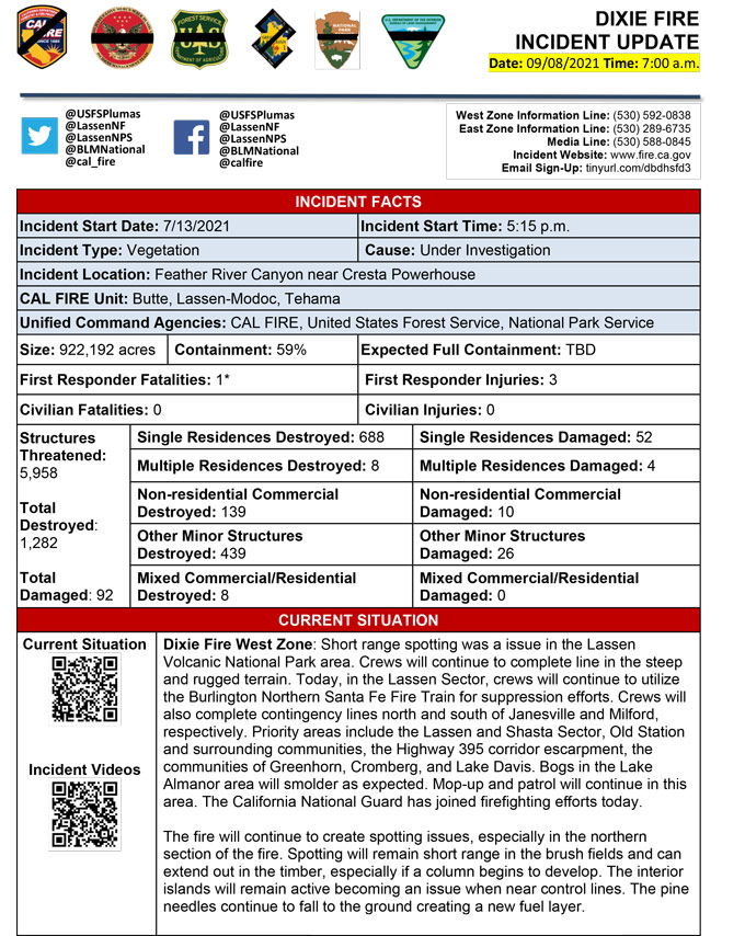
Basic Information
| Current as of | 9/8/2021, 6:56:00 AM |
| Incident Type | Wildfire |
| Cause | Under Investigation |
| Date of Origin | Tuesday July 13th, 2021 approx. 05:15 PM |
| Location | Feather River Canyon near Cresta Powerhouse and Lake Almanor. |
| Incident Commander | Nick Truax, CALFIRE IMT 1; Evans Kuo, GBT1; Mike Minton, NPS |
| Incident Description | Wildfire |
| Coordinates | 39.819 latitude, -121.419 longitude |
Current Situation
| Total Personnel | 4,673 |
| Size | 922,192 Acres |
| Percent of Perimeter Contained | 59% |
| Estimated Containment Date | Saturday October 30th, 2021 approx. 12:00 AM |
| Fuels Involved |
Fuel moistures are historically low, Energy Release Components and BI are in the 97-99%. Northern California remains under a Fuels and Fire Behavior Advisory. |
| Significant Events |
Moderate Single Tree Torching Backing Flanking The fire continues to spot in the southeastern portions of the fire as well as in the northern section which lies within Lassen Volcanic National Park. Fire is burning actively with group torching and ground fire in brush fields and large pockets of timber; potential for reburn in areas of needle cast continue to increase. Interior islands are burning while larger fuels continue to consume within the perimeter. Bogs in the Lake Almanor area continue to smolder. |
Outlook
| Planned Actions |
Planned Actions for the next Operational Period: Priority areas include: the Lassen & Shasta Sectors, Old Station and surrounding communities, the Highway 395 escarpment area including Janesville, Milford and Herlong Junction as well as Lake Davis and the Grizzly Creek area east of the escarpment. Communities of Greenhorn, Cromberg and Davis Lake also at risk, see "East Zone:" below. Continue to establish direct and indirect containment lines south of Old Station, utilizing lines created during the Reading incident. Resources continue to establish containment lines to hold the Hwy 44 corridor and monitor for spots across the highway, while protecting critical fiber optic infrastructure. Complete contingency lines both north and south of Janesville and Milford respectively. Monitor weather for predicted wind event in the area. Provide for service calls within communities impacted by the fire: Chester, Hwy 36 corridor, Hwy 89 Corridor, Hwy 395 corridor, Paxton, Greenville, Jonesville, Crescent Mills, Taylorsville, Prattville, Butte Meadows, Bucks Lake, Meadows Valley, Rush Creek, Warner Valley, Pecks Valley, Williams Valley, Hunt Canyon, Susanville, Janesville, and the Greater Almanor area. Continued mop up of and patrol of 1,000-hr fuels will require a significant amount of resources due to the volume of fuels and the steep and rugged terrain. Continued holding actions and point protection of communities and critical infrastructure will require a significant resource presence for the next several operational periods. East Zone: Resources will continue hold and improve dozer and handline from Lake Davis to Clover Valley and construct dozer and handline to keep fire from spreading further into Dixie Valley, as well as south towards Clover Valley and Portola. East of Milford, construct direct and indirect containment lines on the NW and NE flanks of the fire south from Highway 395 to prevent fire from again impacting Milford and Highway 395. Construct dozer line in Dotta Canyon to the Sugar Fire scar as an alternate contingency line. Continue improving Road 177 and Beckwourth-Genesse Road as secondary control lines. Maintain continment, mop-up, and backhaul of equipment on western and central divisions in the Zone. Structure protection remains in place within Genesee, Dixie Valley, Lake Davis area, Milford, and Taylorsville. |
| Projected Incident Activity |
12 hours: Improved humidity recovery overnight. Inversions continue to develop in the otherwise stagnant air, trapping smoke under the inversion. Active fire behavior due to hot/dry conditions and fuel receptivity. Main fire continues to burn in the Horton Ridge, Dixie Valley, and the Diamond Mountains/395 corridor. Interior islands continue to burn together. Short-range spotting potential 1/4 - 1/2 mile 24 hours: Humidity trend continues a slight upward track as temperatures start on their way down. Wind will increase but will continue to be south to southwest with gusts to 24 mph. Active fire due to hot, dry, and windy conditions. Main fire will continue to burn out interior pockets in and around Horton Ridge, Dixie Valley, Squaw Peak, and the Diamond Mounts/395 corridor. Short-range spotting potential remains in the active portions of the fire as well as the Squaw Peak area. 48 hours: Continued stable and stagnant conditions for overnight with humidity recovery above 30 percent for the ridges. Clouds will begin to enter the area, helping cool temperatures and increase humidity throughout the day. Winds will continue to strengthen with gusts to 26 mph from the southwest. Moderate to active fire behavior predominately along Horton Ridge and Diamond Mountains/395 corridor. Spotting potential remains. 72 hours: A risk of showers and thunderstorms from low pressure moving across the Oregon-California border. This will have to be watched to see if this trend continues, as this is a new development. This would mean stronger, more southernly winds, shifting to the southwest with potential gusts to 30 mph and lightning. Moderate to active fire behavior. Anticipated after 72 hours: If the low pressure crossing scenario develops, this may open the door for more lows to cross through extreme northern California, which would mean moderate wind from the west/northwest for the upcoming weekend. Moderate fire behavior and activity expected. |
| Remarks |
Great Basin Incident Management Team 1 (GBT1) is in command of the East Zone. East Zone Unified Command Agencies: Plumas National Forest and Lassen National Forest. CAL FIRE IMT 1 is in command of the West Zone. West Zone Unified Command Agencies: Bureau of Land Management, CAL FIRE, Lassen National Forest, National Park Service. The fire area is in portions of Butte, Lassen, Plumas, Shasta, and Tehama counties. Active fronts are in: Lassen NF, Lassen NP, and the Caribou Wilderness area; the Lake Davis and Antelope Lake area; highway 395 adjacent to Honey Lake area, as well as on several private timber ownerships. Structures possibly damaged in Dixie Valley area. Waiting on a Damage Inspection assessment to validate damage. East Zone - 7 responder injuries, West Zone - 3 responder injuries A State of Emergency for Butte, Lassen, and Plumas counties was declared by Governor Newsom on July 23rd, 2021. Butte, Lassen, Plumas, and Tehama Counties have declared local emergencies. FMAG has been approved for the Dixie Incident. Regional Order No. 21-07, effective August 31, 2021 through September 17, 2021, closes National Forest Service System lands within the Pacific Southwest Regions inclusive of Plumas and Lassen NFs. The Plumas National Forest implemented Forest Order No. 05-11-00-21-18, effective from July 25, 2021, through September 30, 2021. The Lassen National Forest implemented Forest Order No. 06-21-07, effective from July 27, 2021, through September 30, 2021. Additional values at risk threatened: National Scenic and Historic Trails: Pacific Crest Trail, Bizz Johnson National Recreation Trail. Inventory Roadless Area (IRAs): Bucks Lake (PNF), Butt Mountain (PNF), Chips Creek (LNF), and Cub Creek (LNF). Experimental Forests: Swain Mountain, Blacks Mountain. Research Natural Areas (RNAs): Green Island Lake(LNF), Soda Ridge (LNF), Cub Creek (LNF), Mount Pleasant (PNF). Air Quality impacts: Reno, Carson City, Susanville, Sparks, Fernley and Quincy. Airports impacted by TFR and smoke impacts: Rogers Field (Chester Airport), Ganser Field (Quincy Airport), Westwood Airport, Susanville Municipal Airport, Herlong Airport. Wilderness: Bucks Lake Wilderness (PNF), Caribou Wilderness (LNF), Lassen Volcanic National Park Wilderness. Commercial timber ownerships: Sierra Pacific Industries, W.M. Beaty and Associates, Collins Pine. An estimated $1 Billion dollars of timber has already been destroyed with an additional $1 Billion still threatened. Substantial losses of private and public timberlands have released decades of sequestered carbon, releasing it into the atmosphere with uncalculatable impacts to green house gas accumulations. Waterways: Philbrook Lake (PG&E, LNF), North Fork of the Feather River (PG&E, PNF), Silver Lake (Drinking water, PNF), Thompson Lake (Drinking water, PNF), Butte Creek (T&E species: chinook and steelhead, PNF), Deer Creek (T&E species: chinook and steelhead), Oliver Lake (T&E species: Sierra-Nevada Yellow-legged Frog, LNF), Gold Lake (T&E species: Sierra-Nevada Yellow-legged frog, PNF), Rock Lake (T&E species: Sierra-Nevada Yellow-legged frogs, PNF) Additional T&E species (not listed above): California Spotted Owl, Valley Elderberry Beetle, Shasta Crayfish, Cascades frog, California Red-Legged Frog, Bald Eagle, Golden Eagle, Grey wolf, Fisher, California wolverine, and Sierra Nevada red fox. |
Current Weather
| Weather Concerns |
Near-record heat with valley highs reaching into the middle 90s during the afternoon pushed humidity below 10 percent, and ridge wind gusted up to 27 mph from the southwest. Terrain-driven winds were the primary type of wind across much of the area today, with each slope and drainage driving its own wind pattern. Overnight, an indication of low pressure moving across the Oregon-California border on Thursday night and Friday could lead to enhanced wind and possibly thunderstorms. |
Click here for: California Dixie Fire Tuesday, September 7, 2021 Updates
