


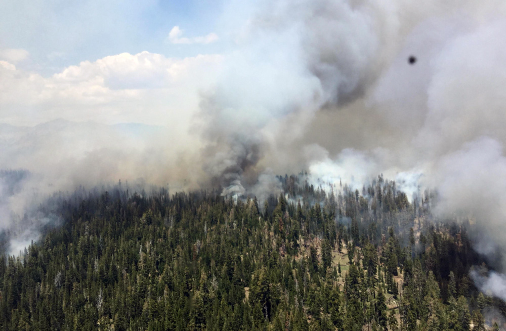
 Burn operations are made safer and more efficient by using aerial (helicopter) ignitions in areas with poor access on the ground. Unstable atmospheric conditions allowed for good smoke dispersion late into the afternoon. Credit: Sierra National Forest - Inciweb
July 2, 2018 - Yesterday’s burn-out operations brought the Lions Fire to 3,575 acres and 35% containment. In a burn-out operation, firefighters introduce fire inside of containment lines and natural barriers, and allow it to move towards the approaching wildfire, thus depriving the approaching wildfire of fuel. Using this technique consumes fuels that otherwise might take much longer to burn and reduces the overall duration of the incident. Burn-out operations continue today on a smaller scale than on previous days.
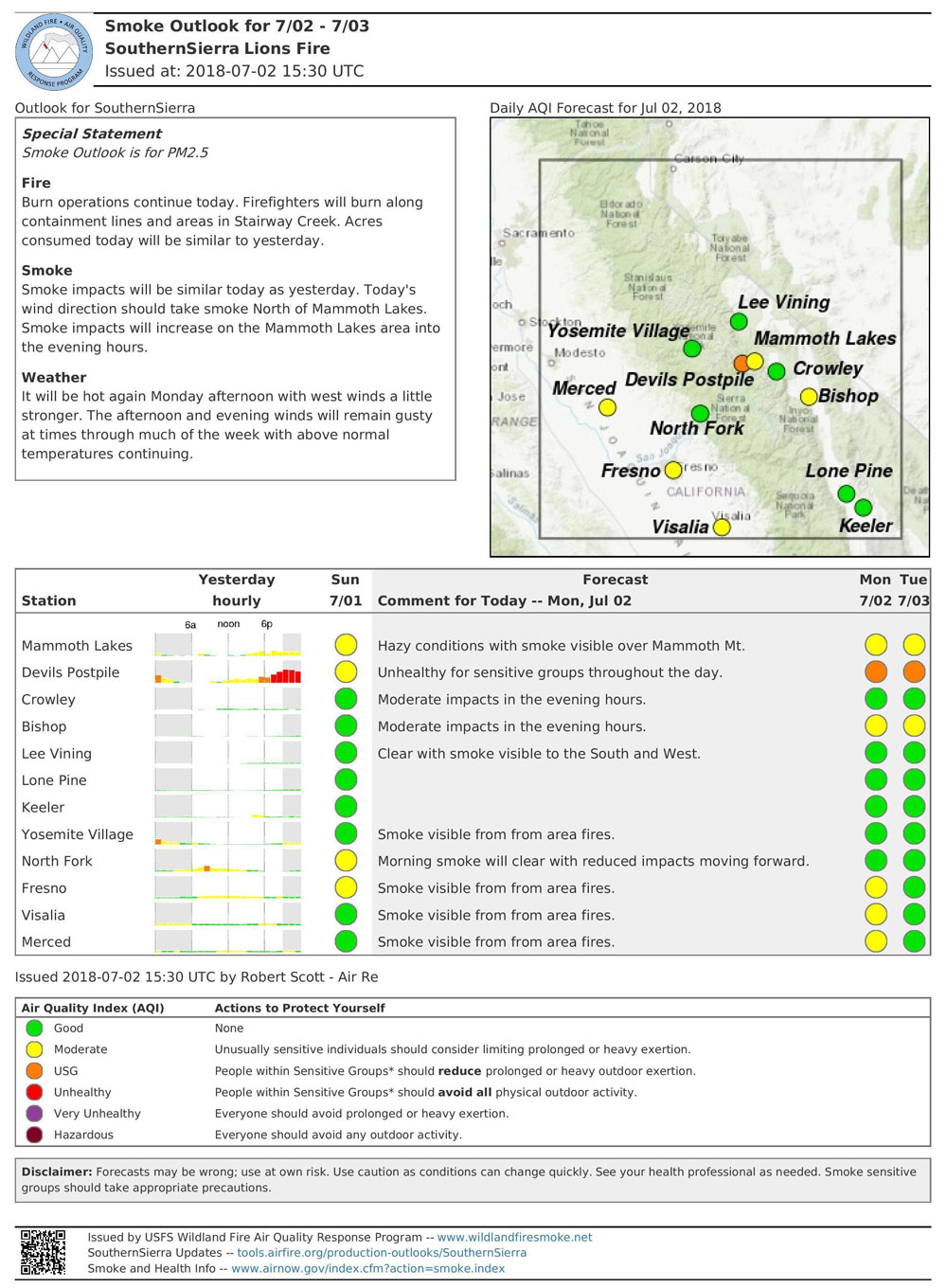
Smoke impacts in Mammoth Lakes and the surrounding areas are expected to continue throughout the week, but lessen each day as the vegetation and dead and down wood within the fire area continues to burn down.
Fire managers are using aerial resources to support a broad range of operations. Helicopters are transporting firefighters to and from their wilderness spike camps, supplying ground operations, and making water drops to cool the fire perimeter. Helicopters are also being used to perform aerial ignitions during burn-out operations in areas where ground access would be unsafe or inefficient.
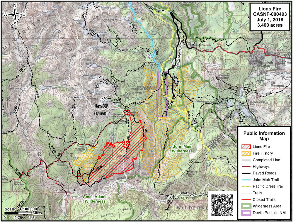
This lightning-caused fire was detected in early June and is located in the Ansel Adams Wilderness. It is located primarily in the Stairway Creek drainage, north and west of the Middle Fork of the San Joaquin River.
To provide for public and firefighter safety, the following National Forest System Trails near the burned area have been temporarily closed: Sierra National Forest Trails No. 26E01 (Mammoth Trail) to the Inyo NF Boundary, 26E14, 26E56, and 26E46 from the Inyo NF boundary. Inyo NF trail closures include 26E01 from the Sierra NF to 2601 junction, and 2601 from the boundary of the Inyo NF and Devils Postpile National Monument (King Creek Trail).
Shuttles to Devils Postpile National Monument and Reds Meadow Valley are running, and trails there are open. The Pacific Crest Trail and the John Muir Trail are open. Visitors should expect smoke impacts of variable intensity.
Air quality forecasts are available at https://airnow.gov/index.cfm?action=topics.smoke_wildfires.
For more information about smoke conditions in the area, visit webcams at www.mammothmountain.com and the alert tab at nps.gov/DEPO
For more information, call (760) 582-5203.
Source: Inciweb
Basic Information
|
Current as of |
7/2/2018, 7:38:43 AM |
|
Incident Type |
Wildfire |
|
Cause |
Lightning Strike |
|
Date of Origin |
Monday June 11th, 2018 approx. 12:00 PM |
|
Location |
7 miles southwest of Mammoth Lakes |
|
Incident Commander |
Stephen Fillmore, Type 3 IC |
|
Incident Description |
The Fire Is Burning At Approximately 6000- 8000' In Red Fir (compact) Needle Cast And Brush As Well As Heavy Blowdown From 2011 Wind Event. |
|
Coordinates |
37.571 latitude, -119.118 longitude |
Current Situation
|
Total Personnel |
347 |
|
Size |
3,575 Acres |
|
Percent of Perimeter Contained |
35% |
|
Estimated Containment Date |
Saturday July 14th, 2018 approx. 12:00 AM |
|
Fuels Involved |
Timber (Litter and understory) Brush (2 feet) |
|
Significant Events |
Aerial ignitions Moderate Flanking Single tree torching |
Outlook
|
Planned Actions |
Crews will continue to improve and burn out control lines utilizing natural barriers to the extent possible. Utilize helicopter drops to check fire in inaccessible terrain north and west of San Joaquin River. Continue burnout operations to secure northeast side. |
|
Projected Incident Activity |
Spread to north/northeast possible with predicted winds. Spread continues to natural barriers and control lines. |
|
Remarks |
2,150 acres on the Sierra National Forest; 1,425 acres on the Inyo National Forest. |
Current Weather
|
Weather Concerns |
Above-normal temperatures and isolated thunderstorms through Monday. Winds west/southwest through the week. |
Air Quality Report 7-2-2018
Fire
Burn operations continue today. Firefighters will burn along containment lines and areas in Stairway Creek. Acres consumed today will be similar to yesterday.
Smoke
Smoke impacts today will be similar to yesterday. Today's wind direction shoud take smoke north of Mammoth Lakes. Smoke impacts will increase on the Mammoth Lakes area into the evening hours.
Weather
It will be hot again Monday afternoon with west winds a little stronger. The afternoon and evening winds will remain gusty at times through much of the week with above normal temperatures continuing.
Source: Inciweb
Related information:
Sierra National Forest Lions Fire Monday Evening Updates
Sierra National Forest Lions Fire Update for Tuesday, June 26, 2018
Sierra National Forest Lions Fire Update for Wednesday, June 27, 2018
Sierra National Forest Lions Fire Update for Thursday, June 28, 2018
Sierra National Forest Lions Fire Update for Friday, June 29, 2018
Sierra National Forest Lions Fire Update for Saturday, June 30, 2018
Sierra National Forest Lions Fire Update for Sunday, July 1, 2018

