


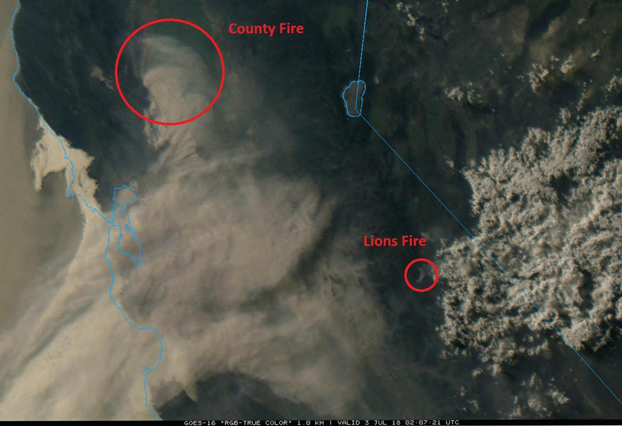
 Mammoth Lakes and the surrounding areas are experiencing increased smoke impacts from the County Fire in Yolo County, while smoke output from the Lions Fire has decreased. Credit: Sierra National Forest - Inciweb
July 4 - 2018. The Lions Fire grew to 4,000 acres yesterday and is now 60% contained. Crews have completed burn-out operations and are currently focused on improving and holding previously constructed fireline. Burning the areas between the main fire and constructed fireline helps reduce the potential for growth near the fire perimeter. Fire personnel are starting to demobilize as containment increases and firefighters shift to monitoring. Currently there are 5 crews and 5 helicopters committed to the fire. Smoke production from the fire is expected to continue to decrease in the coming days.
Air quality in Mammoth Lakes and the surrounding areas is being affected by smoke from larger wildfires elsewhere in the state, such as the County Fire in Yolo County, CA. Air quality readings in Mammoth Lakes remained in the “moderate” range throughout the day yesterday, with similar readings expected today. Residents and visitors are advised to limit their exertion outdoors should periods of heavy smoke occur.
The Lions Fire has burned with similar effects as the Butte Fire in 2017 creating a mosaic landscape within the fire perimeter. Over half of the fire area burned with low to moderate intensity, while small pockets of unburned fuels still remain in the interior. This mosaic pattern creates diversity within the landscape which is vital to ecosystem health and for wildlife habitat.
The following National Forest System Trails near the Lions Fire area have been temporarily closed: Sierra National Forest Trails No. 26E01 (Mammoth Trail) to the Inyo NF Boundary, 26E14, 26E56, and 26E46 from the Inyo NF boundary. Inyo NF trail closures include 26E01 from the Sierra NF to 2601 junction. Trail closures will remain in place until fire management staff determines that it is safe to reopen the area.
Shuttles to Devils Postpile National Monument and Reds Meadow Valley are running, and trails there are open. The Pacific Crest Trail and the John Muir Trail are open. Visitors should expect smoke impacts of variable intensity.
This fire reminds us that our forests are vulnerable to fire, so as we celebrate our nation’s independence today, remember that the use of fireworks are illegal on all national forests at all times.
For more information about the County Fire, visit http://www.fire.ca.gov/current_incidents/incidentdetails/Index/2101
Air quality forecasts are available at https://airnow.gov/index.cfm?action=topics.smoke_wildfires
For more information about smoke conditions in the area, visit webcams at www.mammothmountain.com and the alert tab at nps.gov/DEPO
Source: Inciweb
Basic Information
|
Current as of |
7/4/2018, 8:25:44 AM |
|
Incident Type |
Wildfire |
|
Cause |
Lightning Strike |
|
Date of Origin |
Monday June 11th, 2018 approx. 12:00 PM |
|
Location |
7 miles southwest of Mammoth Lakes |
|
Incident Commander |
Stephen Fillmore, Type 3 IC |
|
Incident Description |
The Fire Is Burning At Approximately 6000-8000' In Red Fire (compact) Needle Cast And Brush, As Well As Heavy Blowdown From A 2011 Wind Event. |
|
Coordinates |
37.571 latitude, -119.118 longitude |
Current Situation
|
Total Personnel |
277 |
|
Size |
4,000 Acres |
|
Percent of Perimeter Contained |
60% |
|
Estimated Containment Date |
Saturday July 14th, 2018 approx. 12:00 AM |
|
Fuels Involved |
Timber (Litter and understory) Brush (2 feet) |
|
Significant Events |
Holding and improving constructed fireline, backhauling of supplies from wilderness |
Outlook
|
Planned Actions |
Crews will continue to improve control lines utilizing natural barriers to the extent possible. Continue to monitor for rollout and spot fires. Utilize helicopter water drops to check fire in inaccessible terrain north and west of San Joaquin River. |
|
Projected Incident Activity |
Fuels continue to consume within control lines, especially in thermal belts with poor recoveries and in dry fuels. Isolated torching possible. |
|
Remarks |
2,375 acres on the Sierra National Forest; 1,625 acres on the Inyo National Forest. |
Current Weather
|
Weather Concerns |
Warming with gusty W-SW winds are expected this week. |
Air Quality Report 7-4-2018
Fire
Interior fuels continue to consume with drier conditions. Crews are monitoring containment lines and extinguishing hot spots.
Smoke
Smoke from other California fires will impact Mammoth Lakes and the Owens Valley area again today. Overall conditions will improve as Southwest winds push smoke from our area. Air quality near the Lions Fire will decrease each evening then improve during daylight hours.
Weather
Breezy afternoon and evening winds are expected for Independence Day. Temperatures and humidity will be near average for this time of year. Breezy afternoon/evening winds will continue through at least Friday.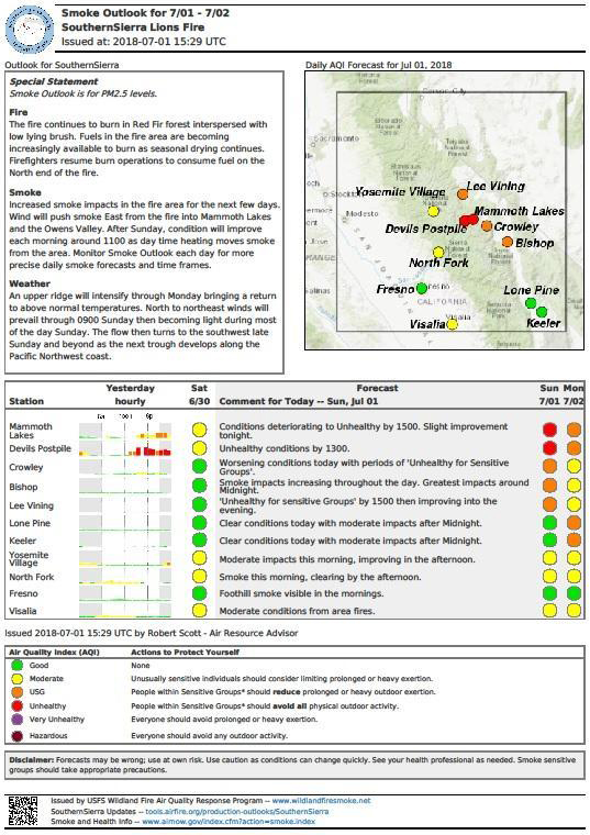
NOTE: Maps represent approximate information.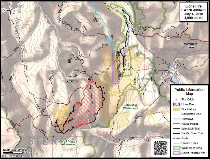
Source: Inciweb
Related information:
Sierra National Forest Lions Fire Monday Evening Updates
Sierra National Forest Lions Fire Update for Tuesday, June 26, 2018
Sierra National Forest Lions Fire Update for Wednesday, June 27, 2018
Sierra National Forest Lions Fire Update for Thursday, June 28, 2018
Sierra National Forest Lions Fire Update for Friday, June 29, 2018
Sierra National Forest Lions Fire Update for Saturday, June 30, 2018
Sierra National Forest Lions Fire Update for Sunday, July 1, 2018
Sierra National Forest Lions Fire Update for Monday, July 2, 2018
Sierra National Forest Lions Fire Update for Tuesday, July 3, 2018

